

.svg)
Intelligently visualizing the built world


.webp)


.webp)
Let's Get To Work Schedule A Project

PLAN BETTER
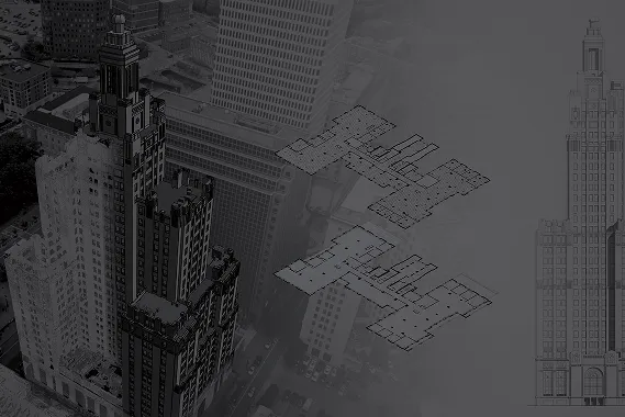
Outdated or missing as-builts don’t just slow you down, they put your entire project at risk. That’s why architects and engineers turn to GPRS Reality Capture Services to get the accurate data they need right from the start.
From early-stage design to renovations, MEP planning, and clash detection, our high-resolution laser scans and BIM modeling deliver precise digital representations of your space – both above and below ground.
Think of GPRS as an extension of your team. We provide digital twins, updated utility as-builts, and tailored deliverables that empower you to detect clashes early, reduce change orders, eliminate rework, and keep timelines intact.
Build BETTER
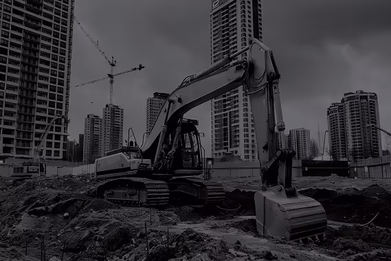
Every delay, change order, or unexpected utility strike eats into your profits and puts your crew at risk. Stop guessing and start building with confidence. The key to a successful project? Accurate data, efficient workflows, and zero surprises.
GPRS gives you the power to take control of your job site. Our advanced utility locating, concrete scanning, reality capture, video pipe inspection, and leak detection services deliver 99.8% accuracy, so you can dig, drill, and build with certainty.
Get a clear view, both above and below-ground, with our SiteMap® platform (patent pending), that combines updated underground utility locations and concrete reinforcement data and your site’s aboveground infrastructure. SiteMap helps you make faster decisions, cut costs, and stay safe.


MANAGE BETTER
Scattered information and outdated as-builts aren’t just inconvenient, they’re a liability. When you're starting a new project, inaccurate data can lead to delays, added costs, and unexpected damage.
GPRS eliminates that risk by confirming known utilities, validating floor plans and structural information, uncovering unknowns, and giving your team a complete, accurate view of your facility – both above and below-ground – before work begins.
Take control with SiteMap®, our powerful GIS platform that brings all your infrastructure data together in one secure, easy-to-use hub. Utility lines, structural elements, water and sewer systems, and facility details – delivered in real time and shareable with your entire team at the click of a button.

SiteMap® Is a project & facility management software application that provides accurate existing condition documentation to protect your assets & people. Visualize your world as it's being built with SiteMap®. See how simple it is to access, read, and share information in this intuitive, secure user interface: Current GPRS customers all receive a complimentary SiteMap® Personal subscription with their utility locate.
Case Study

GPRS is providing our 99.8% accurate utility locating and mapping to UToledo’s campus in exchange for field training for our Project Managers.
Solutions

SiteMap® provides infrastructure information management tailored to meet your organizational needs. Whether you need a single layered utility map or to manage a nationally distributed portfolio, there's a SiteMap® solution for you.
FIND A PROJECT MANAGER NEAR ME
GPRS SERVICES
Ground Penetrating RadaR (GPR)
UTILITY LOCATING Services
811 submits your excavation notification to registered utility facilities within your proposed excavation area. However, not all private utility lines are registered, meaning they would not be marked by member companies, making them the property owner’s responsibility.
To fully visualize the buried infrastructure on your property, it’s vital that you hire a professional utility locating company like GPRS in addition to contacting 811. Our SIM-certified Project Managers employ ground penetrating radar (GPR), electromagnetic (EM) locators, CCTV video cameras, acoustic water leak locators and other equipment to scan for subsurface utilities, including depths and GPS mapping, saving time, money, and even lives by avoiding utility strikes to protect all site employees and contractors from potential line strike damages.
GPRS provides complimentary .KMZ files for all our exterior utility locating projects. Our utility mapping services can create an updated as-built drawing for your campus or facility. GPR services can also be used to locate underground storage tanks (USTs), unknown utilities, and even manholes and well heads.
cctv VIDEO PIPE INSPECTION
Put your site on the Map///
///Georeferenced Utility Linework Overlay

GPRS provides complimentary utility maps for every utility locating project – in easy-to-use file formats like .shp, .kmz. and .pdf. This linework is overlaid on background imagery and delivered immediately upon completion of a project. By supplying updated existing condition drawings, we ensure clients have actionable data for planning, designing or excavation.
///CAD – 2D Utility Site Plan

The GPRS Mapping & Modeling Team can aggregate GPRS field markings into a CAD utility site plan that shows the accurate vertical and horizontal position of underground utility locations. This site plan will help you visualize your project in the planning or design phase, during construction, or even as a permanent record of existing conditions.
///CAD – 3D UTILITY SITE PLAN

GPRS can create a 3D as-built model of the utility infrastructure on your construction site or facility/campus. GPRS collection devices such as gpr, electromagnetic induction, and CCTV video pipe inspection cameras gather site information. 3D visualization of utilities based on the 3D utility data model can be expanded to include above ground features for VDC coordination.
///GIS Infrastructure Software Application

SiteMap® is an application that can visualize georeferenced utility data, site photos and videos, BIM Models, and CAD files all in one platform. The platform is free for GPRS customers and also has available subscription tiers for different construction and facility needs. SiteMap® shows data in a customizable, intuitive, affordable platform that updates data in minutes.
CONCRETE SCANNING
GPRS guarantees our accuracy and your safety with our exclusive Green Box Guarantee. Read about our Green Box Guarantee
3D LASER SCANNING
Laser focused Solutions///
///MECHANICAL ELECTRICAL & PLUMBING

As the leading provider of 3D laser scanning and BIM modeling services, we revolutionize mechanical, electrical, and plumbing (MEP) design processes. Our laser scanning captures precise measurements of existing structures, while our BIM modeling integrates this data for accurate visualization and coordination of MEP elements. This ensures optimal spatial layouts, enhances efficiency, and minimizes errors and rework, delivering superior results for our clients' projects.
///ABOVE & BELOW GRADE

Incorporate your design plans into current infrastructure and underground systems prior to commencing construction. This ensures that your architecture, engineering, and construction (AEC) team, subcontractors, and stakeholders receive a complete 3D BIM model. This model seamlessly integrates 3D Laser Scanning data, Utility Locations, Video Pipe Inspection results, and GPR Data, enabling an intelligent visualization of both existing structures and proposed additions – above and below ground.
///ARCHITECTURAL & STRUCTURAL

We leverage 3D laser scanning and reality capture to revolutionize architectural and engineering practices, generating precise as-built representations and digital twins of structures. Integration into BIM models helps by reducing change orders, work stoppages, budget overruns, and design errors. Laser scanning offers architects and engineers detailed visualization of the built world, enhancing understanding and decision-making in project planning.
///POINT CLOUDS

Point clouds and 3D Laser Scanning assist the AEC industry with accurate built-world data for planning and execution. They reveal insights into infrastructure and MEP features, aiding clash detection, route optimization, and error prevention. Additionally, point clouds facilitate precise as-built documentation, enhancing project accuracy and accountability. They also enable virtual reality simulations for immersive project visualization, fostering better communication and decision-making among stakeholders.

Virtual Tours

LEAK DETECTION Services
The GPRS Difference///

Quality & Consistency
GPRS is in pursuit of 100% subsurface damage prevention. Our 99.8% accuracy rate demonstrates that our equipment, training, and methodology consistently deliver high-quality results nationwide. All 500+ GPRS Project Managers utilize the industry-leading specification called Subsurface Investigation Methodology (SIM) when conducting utility mapping, concrete scanning, sewer camera inspection, or 3D laser scanning.
Our commitment to quality and consistency extends to our world-class customer service center. Our team of expert project coordinators, estimators, and account managers strive to provide you with a frictionless experience when hiring GPRS for ground penetrating radar services, utility locating, concrete imaging, VPI, or 3D laser scanning. You can expect reliable and consistent service every time you contact GPRS.

National Footprint
Ground Penetrating Radar Systems has over 500 SIM-Certified Project Managers to assist you in Intelligently Visualizing the Built World®. This nationwide network is deployed across every market in the US, enabling us to mobilize quickly through our Rapid Response program. This team of field professionals is trained to help you visualize your infrastructure, both above and below ground.
GPRS supports construction projects nationwide, boasting extensive experience in utility locating. We excel in serving projects across multiple sites, overcoming the challenge of finding a single service provider for concrete scanning, utility locating, or CCTV sewer scoping across large regions. Our unique capability lies in nationwide coverage, facilitated by GPRS Project Managers in every major market.

Field to Finish
GPRS's field-to-finish process is underpinned by our 99.8% accuracy rate. Our skilled project managers employ various collection devices such as ground penetrating radar, electromagnetic induction, CCTV crawler cameras, LiDAR, and acoustic leak detectors to gather built world data. This data is then compiled into deliverables by our in-house mapping and modeling team.
These maps and models can be stored within the digital plan room of our software application, SiteMap®. Upon completion of a private utility locate service, our field data automatically creates a map of your site and is delivered in various file formats such as .pdf, .kmz, and .shp. This field-to-finish solution is also delivered through a free subscription to SiteMap®
GPRS INDUSTRY EXPERTISE


COMPANIES WE PARTNER WITH
