.svg)
Engineering
GPRS is a Trusted Partner to Engineers
GPRS delivers accurate and high-quality existing conditions information to help engineers collaborate, optimize efficiency, improve decision making, and ensure safety throughout the lifecycle of a project. Capturing and sharing as-built data before engineering and construction begins will help to ensure a successful project.
GPRS is the only company in the U.S. that can capture a building, facility, or site, above and below-ground, to provide you with accurate as-builts, private and public utility maps, 2D CAD drawings, 3D BIM models, virtual tours, and more documenting architectural, structural, MEP, and subsurface utility existing conditions, and instantly deliver data via SiteMap®, GPRS’ cloud-based digital storage software and app.
3D Laser Scanning Services
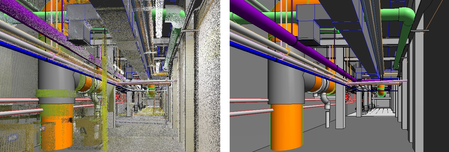
3D laser scanning technology helps those working on historical buildings and sites to capture delicate details and precise measurements in a non-invasive manner. GPRS takes every project from inception to completion with accurate and easy to understand data integration to ensure smooth communication and avoid cost overruns and delays. GPRS 3D laser scanning services document the exact architectural, structural, and MEP system layout and dimensions of existing buildings and sites. GPRS Project Managers use industry-leading Leica survey-grade laser scanners to capture 2-4 millimeter accurate existing site conditions in the form of a point cloud. Our in-house Mapping & Modeling Team can transform those point clouds into customized 2D CAD drawings, 3D BIM models, 3D mesh models, TruViews, and 3D virtual tours at any level of detail for visualization, analysis, design, construction, renovation, prefabrication, and facility modifications.
Utility Locating Services
GPRS utility locating services utilize ground penetrating radar (GPR) and electromagnetic (EM) locating technology to locate, mark, and map existing underground infrastructure such as power lines, gas lines, pipelines, water lines, sewer lines, potential voids, and additional buried facilities and utility lines. This information is critical for projects where construction or excavation activities are planned to mitigate accidental utility strikes, plus keep your team and facility safe. GPRS delivers complimentary CAD utility site maps in PDF, KMZ, and SHP file formats, and can export your utility data into a wide variety of drawings, maps, and models to advance communication and collaboration on your project. All clients receive instant access to complete and aggregated site records in Sitemap®, GPRS’ digital storage software and app, where data is geolocated, layered, and securely shareable.
Concrete Scanning Services
Concrete scanning is a non-destructive method to assess concrete using GPR to locate, identify, and mark utilities and objects such as rebar, post tension cables, beams, conduits, and piping embedded within concrete slabs and structures prior to anchoring, cutting, coring, and drilling. Concrete scanning ensures the safety of workers and prevents accidents by identifying potential hazards before any work occurs. Concrete markings can be 3D laser scanned to create a permanent record of the site, and data can be delivered in 2D CAD drawings, 3D BIM models, and virtual site tours.
Video Pipe Inspection Services
GPRS video pipe inspection services deploy robotic crawler CCTV cameras, lateral launch cameras, and push cameras to inspect and document water, sewer lines, and lateral pipelines to locate clogs, investigate cross bores, find structural faults and damage, and conduct lateral sewer line inspections. GPRS Project Managers deliver NASSCO-certified WinCan reports with the exact location, video, and photo of each defect, ranked by severity so you can plan for maintenance and repairs.
Leak Detection Services
GPRS specializes in all types of leak detection services, including municipal, industrial, and residential. Our Project Managers are leak detection specialists who utilize multiple technologies to locate your leak and have the expertise to map and provide many other insights into your water distribution and fire suppression systems. GPRS does this by utilizing a variety of equipment paired with our industry-leading SIM (Subsurface Investigation Methodology) processes. The equipment and methods used include acoustic leak detectors, leak noise correlators, video pipe inspection (CCTV) cameras & sondes, ground penetrating radar, and electromagnetic locating, among others.

How is 3D Scanning Used in Engineering?
3D laser scan technology allows professionals to complete advanced analysis and off-site visualization to plan for upcoming work. It can be used to tackle extremely technical engineering challenges.
3D laser scanning removes human error from the data collection process and provides quantitative and definitive measurement data. The exact dimensions and locations of complex project details can be recorded with 2–4-millimeter accuracy. The millions of data points gathered from 3D laser scanning can be used to create information-rich deliverables for advanced analysis. Clients have requested dimensional comparisons, floor surface contours, bolt hole locations, and precise measurements for prefabrication, to name a few. Read more about point clouds here.
Data can be assessed on a computer in a 3D space, allowing clients to get a real view of the site without actually having to physically be there. Data is accurate, measurable, sharable, and editable. Custom deliverables, such as 2D CAD drawings and 3D BIM models can be created to bring clarity and resolution to projects. Read more about laser scanning deliverables, here.

GPRS Partners with Engineers
GPRS is a leader in the field of 3D laser scanning and BIM modeling. Our team is highly educated and possesses the technical expertise to provide the precise data needed to solve complex engineering challenges. We have extensive experience partnering with engineers.
What are the Specialized Applications for Laser Scanning?
GPRS utilizes tripod-mounted high accuracy long-range LiDAR laser scanners for data capture from Leica Geosystems. The millimeter accurate point cloud data gathered by laser scanning is a powerful tool for solving complex engineering challenges. We deliver custom data analysis and calculations with high precision.
Michelle Colella, Post-Processing Technical Manager, states, “we try to provide easy to read, intuitive formats that can be easily understood by clients with different industry backgrounds.”
Advanced Analysis Dimensional Drawings and Models Can Be Created For:
- Comparative Analysis (ex: difference between design and as-built)
- Deviation/Deformation Analysis
- Digital Drawings of GPR Markings
- Floor Flatness & Levelness Analysis/Contour Mapping
- Drawings & Analysis to Support Prefabrication, (ex: panels, stairs, elevator shafts)
- New Construction Verification
- Reconciliation of Clients 2D Design Drawings & 3D Design Models
- Structural Steel Shape Probability Analysis
- Volume Calculations
- Wall Plumb Analysis
- Tank Analysis
- Forensic Analysis
Engineering Software
Our team works in industry-standard engineering software packages such as Autodesk and MicroStation, and additional specialized software, providing a vast amount of file types. Our team’s expert software knowledge expedites drawings (plans, elevations, end views, sectional views, etc.) and models (3D mesh, 3D BIM).
- Point cloud file format: .lfm, .pts, .e57, .rcs, .rcp, .las, .lgs, .ptg
- 2D drawing file format: .rvt, .dwg, .dgn, .pdf
- 3D mesh file format: .stl, .ply, .fbx, .obj,
- 3D model file format: .dwg, .stp, .rvt, .ifc,

Partnering to Complete Projects
Our team works closely with each client, building a strong relationship to solve their complex engineering problems. Constant communication with precise data facilitates that relationship.
“I am 100% confident that we can partner to solve any engineering or construction project,” says Nate Baker, the Director for GPRS 3D Laser Scanning Services. “We lead the industry with what we are able to do with point clouds and laser scanning. We aren’t looking to industry norms to dictate what we do. Our goal is to widen the gap between our work and the industry standard.”
GPRS is a Technical Partner
As a technical partner, GPRS can help you determine the best solution based on the problem you are trying to solve. Aaron Hunt says, “We work closely with each client to understand their project scope and provide innovative engineering solutions.”

“The first question we ask clients is ‘what are you really trying to get done?’ We concentrate our efforts with the given budget to solve that problem,” adds Michelle Colella.
GPRS utilizes best-in-class technology from market leaders such as Leica Geosystems and Autodesk to deliver incredible data with trouble-free integration. GPRS laser scanning solutions improve productivity and expedite fieldwork, thereby reducing change orders, delays, and costs.
Examples of Advanced Analysis from 3D Laser Scanning
Prefabrication of ACM Panels at LaGuardia Airport
A client was installing ACM panels to the canopy of a newly constructed terminal at LaGuardia Airport using an overhead lift 80 feet in the air. The construction plans did not match the existing conditions at the site. The installation process needed to be precisely planned to avoid rework. GPRS 3D laser scanned the canopy and curtain wall façade with the Leica ScanStation P50 to capture accurate as-built data and generate 2D drawings and a 3D model to prefabricate panels and expedite installation.

Concrete Formwork of a Wind Turbine Deck
In this project, the concrete formwork of a wind turbine deck was 3D laser scanned. The objective was to compare the formwork to the design requirements, and this was a complicated shape. After providing the client 2D drawings and analysis, modifications were made to the forms to better fit the design documents. After the adjustments were completed, 3D laser scanning was completed again to update the dimensions.

Power Stack Bracket Analysis
One of Georgia’s largest power supply cooperatives requested technical expertise for one of its power stacks. The client wanted to verify all brackets were correctly aligned before installing baffles and determine if the guides needed to be moved to accommodate for thermal growth. The power stack was 3D laser scanned with the Leica ScanStation P50 and the Leica RTC360 laser scanner. Our engineering team delivered intensity map point cloud files, 2D drawings, and an AutoCAD Revit LOD 200 model. The deliverables were used to help define which brackets needed adjustment.

Installing Large-Scale Exterior Signage
A new construction sports stadium was installing large-scale exterior signage. Our client needed to verify the centerlines of the structural steel framework where the signage would be fitted to. The value of our services was recognized almost immediately on this project. Upon reviewing the data, the client noticed that the steel on the north and south ends of the stadium did not align with the design plans. As a result, our client and the project’s general contractor made arrangements for the steel in these areas to be corrected.

3D Mesh of Studio Stage and LED Panels
LED panels have replaced green screens, and are now being used to create sets and backgrounds for immersive 3D virtual reality experiences. A film studio’s stage and LED panels were modeled into a .obj 3D mesh. The client wanted virtual data and an accurate representation of the stage and each LED panel to tie into a virtual reality experience during filming.

Floor Flatness
A general contractor needed to measure the floor flatness of this building to ensure it was a suitable surface for the operation of materials handling equipment. 3D laser scanning is the best way to measure floor flatness and floor levelness with precision, efficiency, and accuracy. Highly detailed point cloud data is used to determine FF and FL values on concrete floor/flatwork. Color elevation maps can be quickly produced to identify the high and low points in concrete and calculate the boundaries of any areas that need to be adjusted.

Floor Surface Contours and Spot Elevations
A solar power plant in Arizona requested floor surface contours, plus a radial grid of spot elevations at specific locations. Aaron Hunt, GPRS's Lead Technical Manager, describes how this was completed. “We have standards setup specific to their needs, so we repeat the process on many of their tanks that are the same layout and dimensions. This is completed when they build new tanks or refurbish. In addition, they asked us to provide wall contours. This is completed by fitting a perfect cylinder to the walls and then conducting a unique analysis. Point cloud data is collected for the walls as a cylinder. The variation between the two is plotted on a horizontal plane, and contours are created from this. We actually "split" the circular walls and flatten them out to this 2D plane to document on drawings.”

3D Laser Scanning Pricing
The cost of 3D laser scanning can vary widely depending on your project scope. GPRS customizes every quote specific to your project’s needs. GPRS Project Managers use 3D laser scanners to capture every detail of your site, delivering building dimensions, locations, and layout with millimeter accuracy. This can include the aboveground structural, architectural, and MEP features, plus underground utility and concrete markings. Our Mapping & Modeling Team can deliver point clouds, 2D CAD drawings, 3D BIM models, 3D Mesh models, TruViews, and Virtual Tours at any level of detail.
For more information on GPRS 3D laser scanning services, click here.

CUSTOM SERVICE PLANS

Scheduling

Pricing

Approach

mapping & Modeling
GPRS delivers the most up-to-date, accurate and comprehensive site data possible in the format required for your project. We provide complimentary KMZ and PDF maps with every utility locate we perform. Our Mapping & Modeling Team can create a wide variety of customizable maps and models, from a simple GPS-enabled map of your utility locate, to highly-detailed 2D CAD drawings and 3D BIM models, depending on your needs.
AS BUILT DRAWINGS
2D MAPS & 3D MODELS
SITEMAP® MOBILE APP

One Call Program

Public Property
Private Property

Embedment
Case Studies


.webp)
.avif)
Related Articles