Multimedia and Entertainment

3D Laser Scanning for Mixed Reality

3D laser scanning can be used in mixed reality (MR), virtual reality, (VR) and augmented reality (AR) applications. The technology helps companies transcend users to a virtual world.

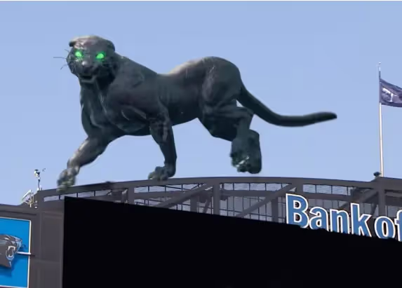
Mixed reality is a blend of physical and virtual worlds that includes both real and computer-generated objects. The two worlds are "mixed" together to create a realistic environment. GPRS has used 3D laser scanning to deliver 3D Revit Models and FBX files for our clients to develop mixed reality experiences for use during sporting events, including football games and the Super Bowl.

For mixed reality, it is important that the existing spatial layout is captured with great accuracy.  When generating the mixed reality experience, computer-generated objects must precisely interact with the physical environment to sell the realism. 3D laser scanning can achieve this.

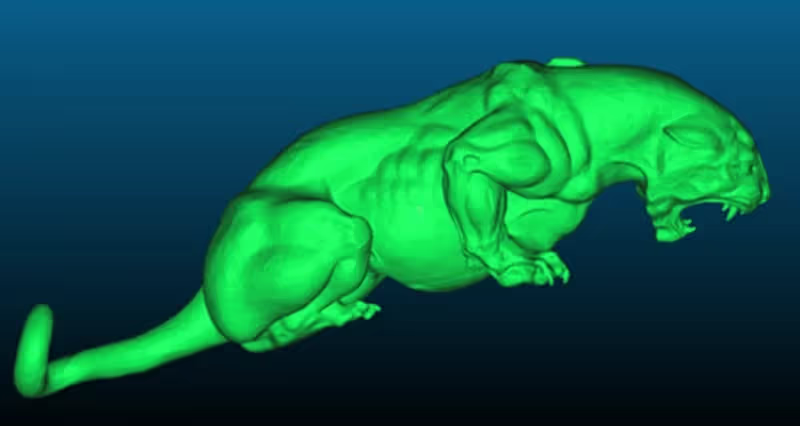
GPRS 3D laser scanning services capture real-world spaces with 2-4 millimeter precision for clients to create engaging virtual reality experiences. For example, VR can enhance learning by developing training programs to immerse users into realistic situations, such as crime scenes or fire scenes that cannot be reproduced easily in life.

GPRS has partnered with The Famous Group on many mixed reality projects, providing the hyper-accurate data that has created the canvases for many of these mixed reality experiences. Here are a few examples of mixed reality fan experiences only made possible by GPRS’ 3D laser scans, point clouds, 3D meshes, and BIM models:

3D Laser Scanning for Augmented Reality

Augmented reality is the technology that expands our physical world, adding layers of digital information onto it. Augmented reality can aid manufacturing operations by reducing production downtime or quickly identifying manufacturing process problems. For business logistics, it can increase efficiency and cost savings across many areas, including transportation, warehousing, and route-optimization.

3D laser scanning captures real-world spaces with 2-4 millimeter accuracy to create engaging virtual reality experiences.

3D Laser Scanning for Video Game Developers

3D laser scanning captures stunning visualization for video game content creation. 3D laser scan technology documents real-world environments and reconstructs them into a dimensionally-accurate 3D digital representation. Environments are quickly captured and rendered and prove to be more realistic and more engaging. Once the environments are in a client's database, they can be adjusted and modified. Photorealistic assets are delivered in high detail with texture, the perfect element for most visualization applications.

GPRS has experience in 3D laser scanning for video game development. 3D scale data is captured in a point cloud file and is used to create deliverables useful to software developers. Deliverables can range from the raw data itself, to 3D models and 3D photographs. Laser scanning can be combined with real time ray tracing to create beautiful renders and realistic looking results for the next generation of video games.

GPRS can support Unreal Engine, Unity, GameMaker, Godot, and other game engines with high quality data for rendering images and environments, or by creating custom scan to BIM models. These large-scale BIM models can be viewed at high speeds and shared to facilitate communications between the designer and the client.

GPRS’ 3D laser scanning, and Mapping & Modeling services helped bring a giant, computer-generated panther to life in an incredible mixed-reality experience created by The Famous Group for the NFL’s Carolina Panthers.

3D Laser Scanning for Projection Mapping

Projection mapping uses video, animation, graphics, and images to map light onto any surface, turning common objects into interactive light displays. From building facades to theatres to sports fields, images are displayed in high-definition quality regardless of the surface. This technology is completely scalable, from a city block all the way down to the side of a building.

GPRS 3D laser scanning services can be used to create a mesh model for projection mapping complex industrial landscapes, buildings, arenas, theatres, and more. Experienced scan technicians use state-of-the-art Leica laser scanners to capture accurate point cloud data. Our in-house Mapping & Modeling team generates a 3D mesh model in an .obj file format containing basic architectural elements including walls, columns, doors, roof, openings, etc. for clients to incorporate the structure’s features into their projection mapping. Data can be used to design 3D multimedia shows using the latest 3D projection mapping or video mapping techniques.

GPRS created a 3D Mesh model of Providence City Hall for a projection mapping display during the holiday season.

3D Laser Scanning for Movies

Laser scanning is an excellent tool in the movie industry for selecting filming locations, pre-visualizing and planning scenes, and to help create stunning CGI and visual special effects (VFX) in post-production. The speed and accuracy of laser scanning allows for environments to be quickly rendered in 3D to a high level of detail and precision. The ability to create exact copies of locations and assets has significantly reduced the time and cost of visualization and provides for more realistic VFX.

It can help location managers searching for interior or exterior venues to serve as the setting for scenes depicted in a script. 3D laser scanning allows you to visit the scene location virtually and to present it digitally to all persons dealing with the production. With 3D laser scan data, the location can be analyzed spatially and geometrically. The digital three-dimensional documentation of the location facilitates planning and decisions before shooting starts.

When utilizing 3D laser scan technology, an entire movie location can be transformed into a computer generated (CG) set. The laser scanner’s software produces a digital 3D point cloud from which detailed measurements can be calculated for design, construction, visualization, or evaluation. Point cloud data can be turned into 3D models, eliminating the cost of modeling sets from scratch. Filmmakers can use the 3D model to replicate, design, and layout a digital scene. The information captured can be used during the current project and in the future for a completely different production.

Laser scan data can be used to recreate environments for virtual sets and LED walls. 3D environments are projected in real time behind actors to provide the illusion of being in a physical location.

Whether in pre-visualization or storyboarding, production or creating special effects, 3D laser scan data offers many benefits. 3D laser scans support planning (design and movie set construction, perspective, lighting, camera paths, equipment placement) as well as digital post-editing (3D modeling or embedding true-to-scale digital contents in correct position).

GPRS was tasked with scanning this Hollywood studio stage and the LED wall panel system behind it to provide our client with an accurate representation of the environment so they could tie virtual reality into the real world.

3D Laser Scanning Pricing

The cost of 3D laser scanning can vary depending on your project scope. GPRS customizes every quote specific to your project’s needs. GPRS Project Managers use 3D laser scanners to capture every detail of your project, delivering building dimensions, locations, and layout with 2-4 millimeter accuracy. Our Mapping & Modeling Team can deliver point clouds, 2D CAD drawings, 3D BIM models, 3D Mesh models, TruViews, and Virtual Tours at any level of detail.

GPRS helps you document real-world environments and reconstruct them into a dimensionally-accurate 3D digital representation.

What can we help you visualize?

Let's Get To Work
Schedule A Project

No items found.
Settings Slider icon

CUSTOM SERVICE PLANS

Rather than send a rigid rate sheet to prospective clients, GPRS can create a customized service plan. We take into account our industry experience, national footprint, and operational/scheduling capacity to craft a customized plan just for you.
Schedule Icon

Scheduling

With one single point of contact for your company, GPRS can schedule underground utility locating, 3D laser scanning, concrete scanning, video pipe inspection, and void detection services for your site with a simple phone call. There is no need to call multiple service providers across a region or nationally. GPRS has Project Managers in every major market in the US and our single point of contact will simplify your scheduling process.
Pricing

Pricing

GPRS understands that clear, understandable, and consistent pricing is a big deal. Our nationwide footprint allows us to streamline our costs on a nationwide basis. We are sure to craft a cost structure that makes sense for the scope of work. Rather than send a blanket rate sheet, we consultatively compose pricing plans for each project.
approach icon

Approach

Every campus, site, and facility pose different challenges. Since our inception, GPRS has completed hundreds of thousands of projects and relies on that experience when crafting a site-specific plan for safety, scanning, and reporting. With the SIM Specification as our guide, we will craft an individualized approach to each and every project. We Intelligently Visualize The Built World™ from facility mapping to utility locating prior to excavation, and will perform the right service for your scope of work.
Mapping and modeling  - GPRS -  Ground Penetrating Radar

mapping & Modeling

GPRS improves project planning and communication by providing clear and understandable maps and models to help you Visualize The Built World™ and share your vision with subcontractors, designers, engineers, and others, easily.

GPRS delivers the most up-to-date, accurate and comprehensive site data possible in the format required for your project. We provide complimentary KMZ and PDF maps with every utility locate we perform. Our Mapping & Modeling Team can create a wide variety of customizable maps and models, from a simple GPS-enabled map of your utility locate, to highly-detailed 2D CAD drawings and 3D BIM models, depending on your needs.

AS BUILT DRAWINGS

Existing drawings don't always show the current conditions of a site. Drawings that are produced in the design phase of a project don't always reflect the exact location of the underground utilities and current as built site conditions. Renovations, repairs, and additions can all render as built drawings out of date. The GPRS Mapping & Modeling Team can deliver up-to-date as built drawings that reflect the actual vertical and horizontal position of underground facilities & features, and structural, architectural, and MEP site details.

2D MAPS & 3D MODELS

Utility locates, concrete scanning, and 3D laser scan data can be processed into up-to-date 2D maps and 3D models to ensure that your team has all the information you need to get the job done right. These maps and models provide an accurate record of utility locations and as-builts for project planning.
The GPRS Mapping & Modeling Team will deliver point cloud data, 2D CAD drawings, 3D BIM models, 3D meshes, TruViews, and virtual tours produced with the highest quality standards. We provide high-precision custom analysis and calculations such as dimensional callouts, tank calibration analysis, floor flatness and levelness analysis, deviation analysis, deformation analysis, volume calculations, wall plumb analysis, and more.
Maps, models, and analyses are produced and hosted for your use at any level of detail in a variety of formats such as Revit, AutoCAD, ReCap, Navisworks, Civil 3D, BIM360, A360, Bentley, Leica Cyclone, Cintoo, NavVis Ivion, and more. The GPRS Mapping & Modeling Team has optimized workflows for importing data, registration, creating maps and models, quality checks, and transferring data to clients. We deliver the data you need in the format you need to access up-to-date and accurate facility and infrastructure information.

SITEMAP® MOBILE APP

When we conduct an underground utility locate, GPRS stores all subsurface infrastructure data in SiteMap®, a secure digital platform that houses all your utility locate PDF and KMZ files. You can access your data from any laptop or mobile device and securely share it with your team. Within your files, you will find interactive subsurface maps, annotations, and more, where you can toggle layers and lines on or off to streamline information and communicate only the data you need. You can even measure site features and segment maps geographically to drill down to specific project points for prefabrication or excavation needs.
GPRS Project Managers can complete multiple mobilizations to a jobsite – before, during and after construction – to record subsurface and as built data in real-time. The data captured can be tied together into living maps and models and saved into a database for reference.
How can GPRS can help you streamline your next project to Intelligently Visualize Your Built World™?
One Call Program

One Call Program

GPRS exceed industry performance when it comes to the accuracy of our utility locating. Our team of Project Managers can continue the support of your project by crafting a one-call program from when your project transitions to the O&M phase.
Public Property

Public Property

Damage prevention is critical when excavating in a public right-of-way. Using the 811, call before you dig system, is an essential step to take when trying to avoid underground utility strikes. It's the law! GPRS is able to contract and perform one-call type utility locating for your underground assets.
Public Property

Private Property

A utility locate on private property is not complete until a private utility locator like GPRS has been called to comprehensively locate the entire campus. GPRS can create a one-call type program for your facility or campus in the case that you have utilities that lie within public property.
Embedment

Embedment

Our highly trained Project Managers have extensive experience locating conduits, rebar, cables, pipes, ducts, sleeves, and other hazards embedded in concrete slabs and other structures with ground penetrating radar technology. Cutting, coring, or drilling into these objects can cause damage to utilities and jeopardize the health and safety of workers on site.

FREQUENTLY ASKED QUESTIONS

right arrow  - GPRS -  Ground Penetrating Radar

Will you be able to work with my schedule to avoid disrupting business operations?

Yes! GPRS tailors our services to meet your needs, and that includes working nights and weekends to help limit disruptions to normal business operations. The equipment that GPRS uses is battery operated, emits less radiation than a cell phone, and less noise than a household vacuum cleaner, allowing us to work discreetly.

right arrow  - GPRS -  Ground Penetrating Radar

Can you provide services quickly?

Yes! Our nationwide presence means that a GPRS ProjectManager will be on your jobsite as quickly as 24 hours after initial contact.

right arrow  - GPRS -  Ground Penetrating Radar

Do you have enough manpower to cover multiple stores/sites at one time?

Yes! With over 500 Project Managers strategically stationed across every major market in the U.S., we can respond rapidly to as many sites as needed.

right arrow  - GPRS -  Ground Penetrating Radar

What do I get when you conduct a service for me?

GPRS provides a Job Summary report with basic project information for very project we complete. We also provide complimentary KMZ and PDF maps with every utility locate we perform. And, when we perform a utility locate for you, you receive a complimentary Personal subscription to SiteMap®, our industry-leading, cloud-based infrastructure management platform where you can access, view, and securely share your digitized, layered utility maps 24/7. Beyond that, our Mapping & Modeling Team can create anything from a simple, GPS-enabled locating map of your utility locate, to highly detailed, 2D CAD drawings and 3D BIM models, depending on your needs.

right arrow  - GPRS -  Ground Penetrating Radar

Can you complete your work without my team on site?

Yes, GPRS Project Managers have the capability to complete work with, or without your team present on site, as long as access is granted to the work area. Details of our findings will be communicated to your team immediately upon completion of each project.

GPRS Employees at work | GPRS Image