.svg)
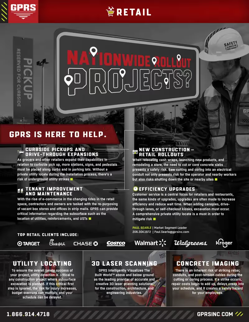
Retail & Restaurant Construction


CURBSIDE PICKUPS, SIGNAGE, AND DRIVETHROUGH EXPANSIONS
Expanding curbside pick-ups & drive-throughs for groceries, big box stores, QSRs, and financial institutions means more stations, signs, bollards, and pedestals. Installing them without knowing your existing conditions above and below-ground puts you at risk for clashes, rework, and utility strikes.
TENANT IMPROVEMENT AND ADAPTIVE REUSE
Planning updates or completing due diligence prior to purchase requires everything: accurate BOMA calculations and floor plans, utility maps, sewer inspections, concrete clearances, and BIM models to get the job done. GPRS can handle it all: Reality capture, utility locates, concrete scans, sewer system maps, and more.
NEW CONSTRUCTION RETAIL ROLL-OUTS
Store remodels, product launches, and relocating cash wraps can all require you cut reinforced concrete. Knowing where you can cut, core, and anchor safely without clashes, striking an electrical line, or critical concrete reinforcement, is vital to avoid injuries, damages, and delays for a safe and successful project.
MULTI-SITE SOLUTIONS
Consistent, accurate, and actionable site data gives you control – of workflows, schedules, and budgets – for one store or hundreds of locations. GPRS provides 99.8% accurate utility and concrete data, construction-grade structural reality capture, NASSCO-certified video pipe inspections, and more, with scalable solutions that put you in control.
2nd-GEN SPACES
Second-generation commercial spaces or 2nd-Gen spaces come with existing infrastructure – and hidden risks. GPRS helps architects, engineers, and contractors confidently repurpose these spaces with expert utility locating, concrete scanning, and 3D laser scanning services. We deliver accurate utility maps, concrete imaging, point clouds, 2D CAD drawings, and 3D BIM models to reduce surprises, delays, and costs.

GPRS Delivers Complete Infrastructure Visualization
GPRS provides as-built construction services to the commercial and retail industry. Our utility locating, concrete scanning, 3D laser scanning, video pipe inspection, and leak detection services capture precise architectural, structural, and MEP details, plus subsurface utility and concrete reinforcement locations of restaurant and retail locations for layout, renovation, and construction projects. GPRS services can be used for a variety of construction applications, from existing as-built drawings and utility maps to plan for renovation and maintenance, to 3D BIM models documenting layout and equipment, and more.
GPRS is the only company in the U.S. that can capture your entire building or site, above and below-ground, to provide you with accurate as-builts, private and public utility maps, 2D CAD drawings, 3D BIM models, virtual tours, WinCan reports, and more documenting architectural, structural, MEP, and subsurface utility existing conditions, and deliver data instantly via SiteMap®, GPRS’ cloud-based digital storage software and app.
Utility Locating Services
GPRS utility locating services utilize ground penetrating radar (GPR) and electromagnetic (EM) locating technology to locate, mark, and map existing underground infrastructure such as power lines, gas lines, pipelines, water lines, sewer lines, potential voids, and additional buried facilities and utility lines. This information is critical for projects where construction or excavation activities are planned to mitigate accidental utility strikes, plus keep your team and facility safe. GPRS delivers complimentary CAD utility site maps in PDF, KMZ, and SHP file formats, and can export your utility data into a wide variety of drawings, maps, and models to advance communication and collaboration on your project. All clients receive instant access to complete and aggregated site records in Sitemap® GPRS’ digital storage software and app, where data is geolocated, layered, and securely shareable.
Concrete Scanning Services
Concrete scanning is a non-destructive method to assess concrete using GPR to locate, identify, and mark utilities and objects such as rebar, post tension cables, beams, conduits, and piping embedded within concrete slabs and structures prior to anchoring, cutting, coring, and drilling. Concrete scanning ensures the safety of workers and prevents accidents by identifying potential hazards before any work occurs. Concrete markings can be 3D laser scanned to create a permanent record of the site, data can be delivered in 2D CAD drawings, 3D BIM models, and virtual site tours.
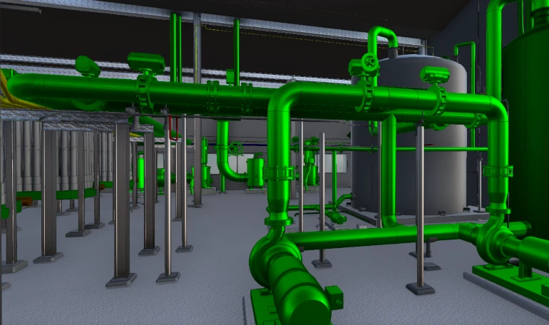
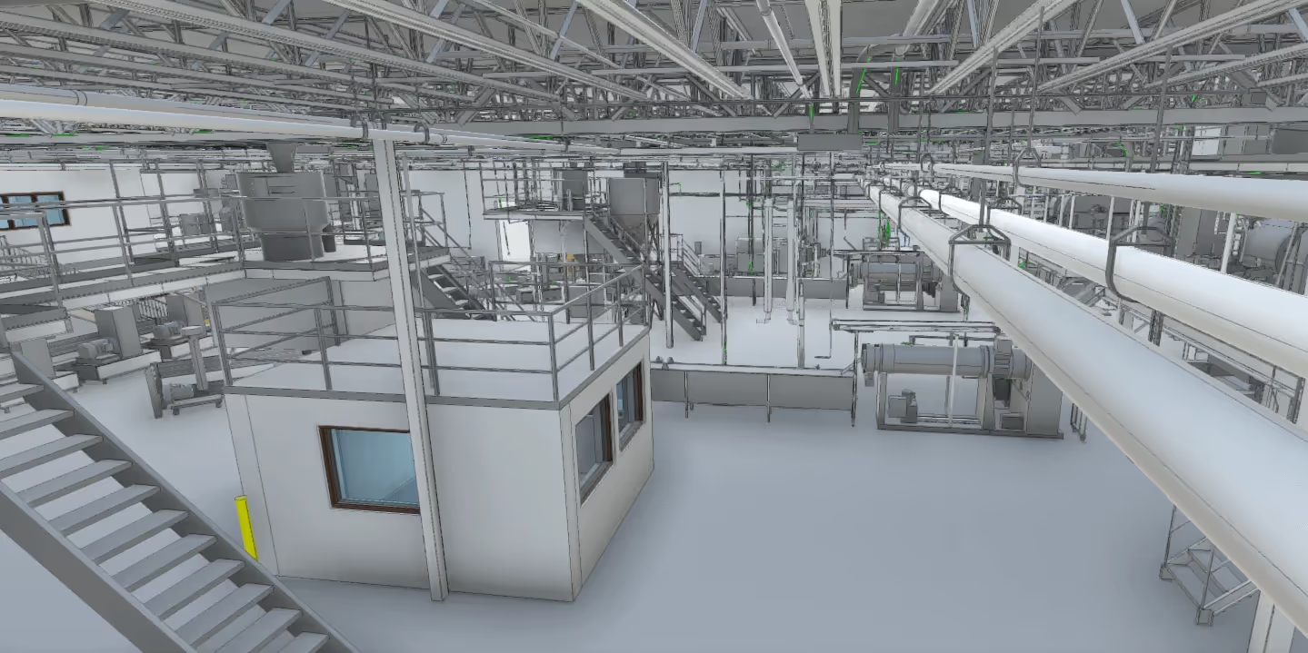
3D Laser Scanning Services
GPRS 3D laser scanning services document the exact architectural, structural, and MEP system layout and dimensions of existing buildings, facilities, and sites. GPRS Project Managers use industry-leading Leica survey-grade laser scanners to capture 2-4 millimeter accurate existing site conditions in the form of a point cloud. Our in-house Mapping & Modeling Team can transform those point clouds into customized 2D CAD drawings, 3D BIM models, 3D mesh models, TruViews, and 3D virtual tours at any level of detail for visualization, analysis, design, construction, renovation, prefabrication, and facility modifications.
Video Pipe Inspection Services
GPRS video pipe inspection services deploy robotic crawler CCTV cameras, lateral launch cameras, and push cameras to inspect and document water, sewer lines, and lateral pipelines to locate clogs, investigate cross bores, find structural faults and damage, and conduct lateral sewer line inspections. GPRS Project Managers deliver NASSCO-certified WinCan reports with the exact location, video, and photo of each defect, ranked by severity so you can plan for maintenance and repairs.
Leak Detection Services
GPRS specializes in all types of leak detection services, including municipal, industrial, and residential. Our Project Managers are leak detection specialists who utilize multiple technologies to locate your leak and the expertise to map and provide many other insights into your water distribution and/or fire suppression systems. GPRS does this by utilizing a variety of equipment paired with our industry-leading SIM (Subsurface Investigation Methodology) processes. The equipment and methods used include acoustic leak detectors, leak noise correlators, video pipe inspection (CCTV) cameras & sondes, ground penetrating radar, and electromagnetic locating, among others.


Let's Get To Work
Schedule A Project


CUSTOM SERVICE PLANS

Scheduling

Pricing

Approach

mapping & Modeling
GPRS delivers the most up-to-date, accurate and comprehensive site data possible in the format required for your project. We provide complimentary KMZ and PDF maps with every utility locate we perform. Our Mapping & Modeling Team can create a wide variety of customizable maps and models, from a simple GPS-enabled map of your utility locate, to highly-detailed 2D CAD drawings and 3D BIM models, depending on your needs.
AS BUILT DRAWINGS
2D MAPS & 3D MODELS
SITEMAP® MOBILE APP

One Call Program

Public Property
Private Property

Embedment
Case Studies


.avif)


Related Articles