Software platform, Autodesk, is on a sprint to the finish line for the Los Angles 2028 Olympics (LA28).

The U.S. company was officially named the Design and Make Platform for LA28 to help meet sustainability goals and streamline construction. Autodesk will also have the enormous task of being the software used by all architects and key stakeholders for retrofitting existing buildings to host the games and ceremonies, instead of constructing them from scratch.
The Billion Dollar Plan
More than $1 billion in investment have been reserved for the temporary overlay and construction plans, which include more than 40 venues. LA28, will mark the very first Olympic Games in history that will have no new permanent venues built to host the games. Instead, all sites being used will be existing world class stadiums and venues across the Los Angeles Region. Some of these stadiums, known around the globe, include the Staple Center, home of the Los Angeles Lakers, LA Memorial Coliseum, home of the University of Southern California (USC) football team, as well as SoFi Stadium, home of the Los Angeles Rams.
.avif)
Adaptive Reuse, BIM, & Design Support Sustainability Goals
Autodesk’s technology tools including Construction Cloud and Building Information Modeling (BIM) will play a central role in achieving sustainability goals for LA28. These tools will be used by thousands of key stakeholders over the next four years including engineers, architects, general contractors, amongst other key contributors for better collaboration, planning, and design as projects begin to move forward.
With the goal of constructing no new permanent venues to host the next Olympic Games, adaptive reuse solutions by way of retrofitting existing structures will be critical. Amy Buzel, Executive Vice President, Architecture, Engineering, and Construction Solutions at Autodesk, shared in a comment on the companies press release of the partnership with LA28 “At Autodesk, we believe the most sustainable building is the one already built. That’s why we’re excited by LA28’s ambitious plan to retrofit existing structures to ensure sustainability is at the forefront of the LA28 Games venue plan.”
By focusing on adaptive reuse strategies, significant cost savings of up to 16% could be realized for LA28 when compared to new construction projects with methods supporting approximately 18% less work time helping enhance cost and time savings.
What is Adaptive Reuse?
Adaptive Reuse is defined as the process of repurposing or retrofitting an unused or existing building for a temporary or permanent new purpose instead of demolishing it. In this renovation process, it is important to preserve the historical and architectural features of the structure being renovated, if possible.
There has been a recent rise in adaptive reuse strategy not only for large events like the upcoming 2028 LA Olympic Games, but also in retail and corporate environments, where outdated and unused office spaces are being converted into spaces used for other potential uses. This approach supports sustainability goals to building development, because it can help reduce waste, preserve architectural heritage, as well as revitalize communities.
How GPRS Supports Adaptive Reuse & Retrofit Projects
On many adaptive reuse and retrofit projects, architectural firms in charge will first hire a company like GPRS or Existing Conditions (a GPRS Company) to 3D laser scan the building being retrofitted. This process of accurate reality capture allows for existing condition data and accurate as-builts to be developed and given to the architect to aid in planning and design.
Many projects face large amounts of downtime and costly reworks due to inaccurate data being used from the get-go, and this helps proactively mitigate those types of scenarios using 3D Laser scanning and BIM modeling.
How The Process Works
In the process of 3D laser scanning an existing facility, GPRS accurately identifies and documents all visible elements of a structure. These include walls, windows, HVAC, mechanical, electrical, and plumbing features. With this type of accurate data, architects can focus on design rather than verifying existing building conditions.
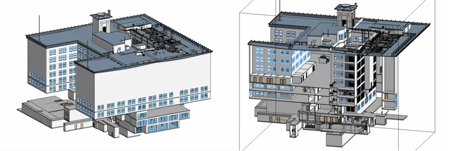
The GPRS Mapping & Modeling Team transforms point cloud data captured by the laser scanner into a 3D building information model (BIM) as shown in the image below. GPRS delivers the as-built model via SiteMap®, a cloud-based software enabling architects and project teams to securely view and share project data from any device.

The BIM model empowers architects to explore design options and convey the project's vision. It can help the architect iterate and refine design changes in a virtual environment, offering innovative solutions for adaptive reuse and retrofit projects.
With this precise data, architects can decide on elements for reuse and materials requiring renovation, from the roof to doors, windows, and walls. The BIM model aids in preparing detailed construction plans specifying structural layouts, MEP system layouts, materials, and finishes. Additionally, architects can present design plans to the Virtual Design and Construction (VDC) team and contractors for accurate timelines and cost estimates.
LA Stadiums GPRS Has Scanned
An example of how this 2-4 millimeter accurate 3D laser scanning data ties in to the 2028 games and venues is from when our team at GPRS created an integrated Revit 3D BIM Model of Sofi Stadium, home of the Los Angeles Rams.
This project involved 3.1 million square feet, 70,240 seats, 260 executive suites, and an additional 2.2 million-pound Infinity Screen by Samsung video board suspended from the roof over the field.
%2520of%2520Stadium.avif)
How Quickly 3D Laser Scanning Can Give Results

In just two days’ time, a GPRS 3D laser scanning Project Manager documented the entire stadiums as-built conditions with 2–4-millimeter accurate reality capture using a RTC360 laser scanner. This data included:
- field goal posts
- sidelines
- end zones
- walls
- tunnels
- scoreboards
- concourse
- stairs
- stands
- suites
As a result of the existing conditions documentation of the stadium, a high intensity map point cloud in .rcs format and a Revit 3D BIM Model of the stadium was delivered for our customer’s use.

These maps and models produced in house by GPRS’ Mapping & Modeling Team helped,
• Streamline workflows
• Avoid clashes, reworks, change orders
• Reduce or eliminate costly mistakes
• Prevent damages & injuries
• Eliminate communication bottlenecks and siloed information
Over 40 of Los Angeles’s premier stadiums and venues will be renovated and adapted for the use of the 2028 Olympic Games, and the team at GPRS, is ready and able to support our design build, architectural, engineering, and construction customers’ needs throughout the entire process.
To learn more about how we can support your projects sustainability goals through our accurate 3D laser scanning, reality capture, and BIM modeling services, click the link below.
Frequently Asked Questions
What is 3D Laser Scanning?
Great question! 3D laser scanning is a construction, engineering, and architectural tool often used to document the existing conditions (as-builts) of any structure.
How Does 3D Laser Scanning Capture Existing Conditions Of A Job Site Or Building?
The primary way a laser scanner works is to send light pulses at high speed which reflect off objects and return to the scanner’s sensor (LiDAR). For each pulse, the distance between the scanner and object is measured by determining the elapsed time between the sent and received pulses. Each data point is converted to a pixel with a known x, y, and z coordinate.
Laser scans are taken in multiple positions around a site from varying viewpoints. Millions of data points are captured and processed into a point cloud, creating an accurate 3D as built data set of the job site or building. This all happens very quickly, with some scanners, like our Leica RTC360, capturing and calculating 2 million points per second with 2-4 mm accuracy.