

.svg)

.webp)
///gprs utility locating services


///what is the cost of utility locating?
Professional utility locating services are priced based on your location, site conditions, job scope, and the complexity of the subsurface infrastructure involved. GPRS provides customized quotes based on those factors once we have a clear picture of your project needs.
When you hire a professional private utility locating company like GPRS, you're leveraging our investment in equipment, experience, and education. Purchasing GPR utility locating equipment can run anywhere from approximately $14,000 to more than $100,000 depending on the system and application, not including training.
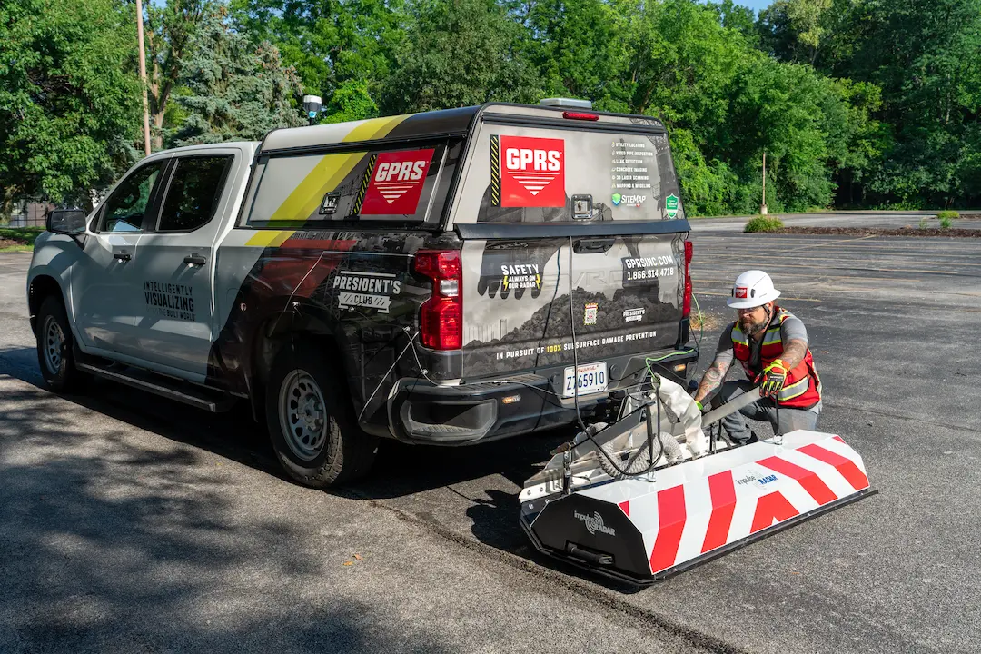
High-Speed 3D GPR Array
Added Accuracy for Roadway, Right-of-Way, Full Site Scans & S.U.E. Collaboration
Cost and traffic control concerns can make it difficult, if not impossible, to conduct a traditional utility locate in an active road or right-of-way. Rather than relying on existing S.U.E. Level C, D, and 811 registered data, municipal managers, utility managers, and engineers can receive existing subsurface conditions information without paying for separate GPR & EM utility locates, CCTV VPI sewer scopes, and without impeding traffic flow.
Benefits for Large Campuses & Facilities Managers
Large campus and facilities managers can quickly visualize the subsurface of complex environments and enhance the accuracy of their permanent utility records by supplementing a full site scan with high-speed array data in roads, parking lots, alleys, and any other drivable areas.
Advantages for Subsurface Utility Engineers & Engineering Firms
Subsurface utility engineers and engineering firms performing infrastructure design work can use high-speed roadway GPR scans to supplement their existing S.U.E. Level D & Level C survey data and 811 public/registered utility locates for a more comprehensive picture of their buried systems. GPRS can provide you with anything from raw data to CAD drawings, to full subsurface 3D BIM models, depending on your needs.


///PROJECT CYCLE SOLUTIONS
.svg)
///THE RIGHT TOOLS


///Utility CAD & BIM deliverables
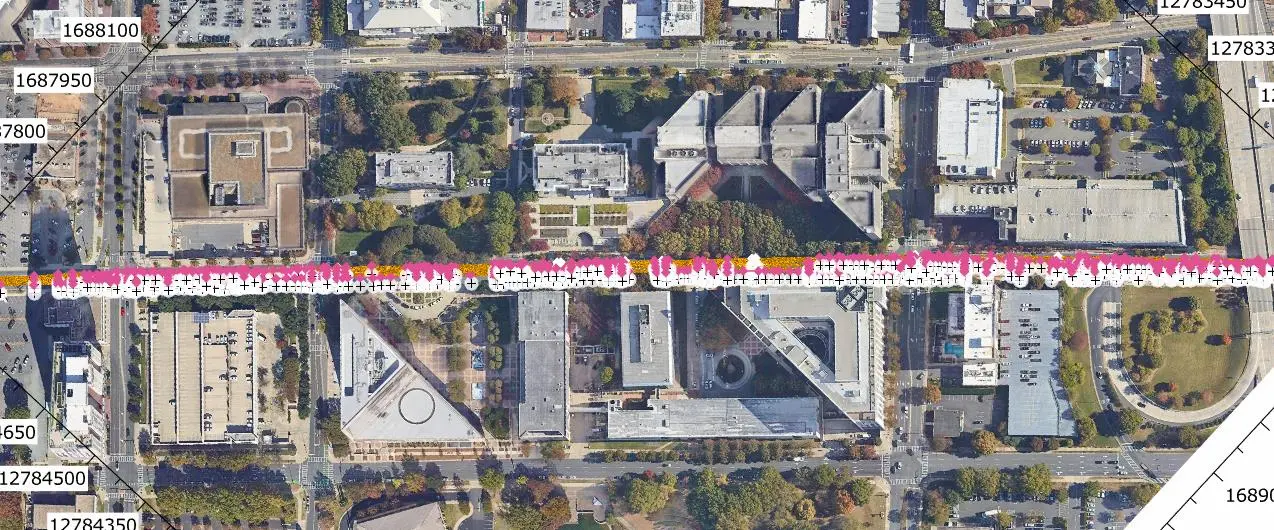
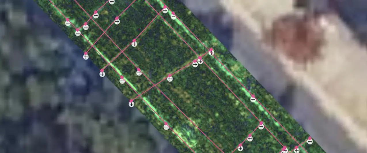
///Georeferenced Utility Linework Overlay

Every GPRS customer receives a complimentary PDF and .KMZ file of their utility map. Plus, we also provide a layered, georeferenced, and 99.8%+ accurate interactive digital utility map via SiteMap® for every utility locate or full site scan we provide. All GPRS customers receive a complimentary SiteMap® Personal subscription with their utility locate so that their subsurface utility information is secured and accessible 24/7 via desktop or mobile devices via the SiteMap® Mobile App.
///CAD – 2D Utility Site Plan

If you need accurate existing condition documentation in 2D format for contractors, trades, and engineers, the GPRS Mapping & Modeling Team has you covered. We can convert your utility field markings, captured with either 3D photogrammetry or LiDAR (3D laser scanning) to create accurate CAD as-builts of your utility infrastructure. Learn more about our CAD team, here.
///CAD – 3D UTILITY SITE PLAN

GPRS can locate every feature and facility, above and below-ground, and with the help of 3D technology, can capture those 99.8%+ accurate measurements to create a comprehensive 3D BIM model or conceptual site model (CSM) of your site. Our Mapping & Modeling team can even create an integrated model using utility markings and 3D laser scans to provide an accurate 3D object that incorporates all of your above and below-ground features, and even proposed changes, to help you design, plan, and build better. Learn more about 3D utility and facility modeling, here.
///GIS Infrastructure Software Application

Every GPRS customer receives their digitized, secured, and accessible utility locates, maps, and models via SiteMap®, our GIS-based infrastructure and facility management software application. In most cases, your utility locating information and layered utility map will be available within five minutes of the completion of your job, so that you can control the quality of your utility data, secure it, and share it with those you designate. GPRS customers receive a complimentary SiteMap® Personal subscription with any GPRS job. Learn more about SiteMap®, here.

///GPRS COMMITMENT
GPRS commits to:

YOUR NEXT STEPS:

.svg)
///INDUSTRIES We serve

Power Transmission & Distribution

Telecom

Renewable Energy

Oil & Gas

Power Generation

Facilities

One Call

Environmental Due Diligence

Civil, Road & Bridge

Design Builds & Remodels

Education

Retail & Restaurant Construction

Water & Sewer
Electric Vehicle Charging

Engineering & Surveying
Other


///CONTROL DATA CONTROL DAMAGE


///Case Study

.svg)
.svg)
The utilization of Subsurface Investigation Methodology (SIM) and multiple complementary technologies allowed for the capture of accurate existing underground utility locations and mapping
.svg)
///WHAT TO EXPECT WHEN HIRING GPRS
.svg)
.svg)


///Case Study

200+ laser scans captured 350,000 s.f. to document existing above ground conditions, which GPRS Mapping & Modeling turned into a 3D BIM model to assist in planning storm drain reroutes.
///FREQUENTLY ASKED QUESTIONs
Utility locating pricing varies by project because every site is different. GPRS structures each quote based on project scope, and factors such as the total area being scanned, soil conditions, the depth and density of utilities, night or weekend work, and the deliverables you need. Instead of offering a one‑size‑fits‑all number, GPRS tailors pricing to your specific site to ensure accuracy and value. Contact us for pricing information.
GPRS utilizes a rigorous set of processes and complementary technologies to locate and map underground utilities. The process we use is known as SIM – Subsurface Investigation Methodology – and it is the backbone of our 99.8% accuracy rate in utility locating. Our Project Managers utilize ground penetrating radar (GPR), electromagnetic (EM) locators, and a set of precise, standardized procedures to help you visualize your underground infrastructure. We mark-out various utilities on the surface with spray paint and/or flags, plus map the area utilizing Real-Time Kinematic Positioning – the most accurate satellite geospatial technology available. Our findings and an interactive digital utility map are then delivered via SiteMap® (patent pending), our industry-leading GIS software platform.
Our Project Managers use ground penetrating radar (GPR), electromagnetic (EM) locators, and radio frequency (RF) transmitters to detect, mark and map subsurface utilities. GPR identifies non-conductive materials like plastic or concrete, while EM locators trace conductive lines such as electric or communication cables. These tools are often used in tandem for comprehensive results as part of our SIM process.
A utility locate identifies and marks the position of underground utilities on-site using flags or paint. A utility map, by contrast, is a digital or physical record that documents the location and depth of these utilities for future reference. Mapping often follows a locate and provides a permanent, georeferenced record. GPRS does all three: We do a surface mark-out, provide you with a free PDF and KMZ file of your utility map overlaid on a satellite image, and deliver an interactive, layered utility map via SiteMap, so you have your findings available from anywhere, 24/7, in a secure shareable platform.
811 services only mark public utilities, i.e., those owned and maintained by utility companies. They do not identify private or unregistered utilities, which include all lines beyond the meter or on private property. To avoid costly damage or safety risks, private utility locating services like GPRS are essential for a complete picture.
Striking a utility line can result in serious injury, service disruptions, environmental hazards, and legal liability. Damaging a gas or electric line, for example, can lead to explosions or electrocution. And hitting a water main can cause an entire community to lose access to fresh water. Any utility strike puts your workers, the project, and your reputation at risk. Prevention through accurate locating is critical to project success
Real-Time Kinematic (RTK) positioning is a high-precision geo-positioning method that uses satellite correction data to achieve centimeter-level accuracy in the right conditions. In utility locating, RTK ensures that mapped utility data is geospatially accurate, enabling precise excavation and long-term asset management.