GPRS confirmed the accuracy of 811-registered utility locates and discovered an unmarked stormwater system running across the intended path of an 80-foot-long trench, ensuring the safe installation of deep well anodes along an existing gas distribution line.
GPRS Project Manager Darrell Fernandez was called out to San Pablo, California, where a contractor was installing deep well anodes along the line in a residential neighborhood.
What Are Deep Well Anodes?
Deep well anodes are a system of vertically drilled anodes designed to protect buried structures such as pipelines and storage tanks from corrosion. An anode is placed in a conductive backfill material deep within the ground, typically in a drilled well, to reach layers with lower electrical resistance, allowing for a more efficient distribution of current to protect the other buried, metal structures by acting as a sacrificial metal that corrodes instead of the protected structure.
The anodes are connected to a power source, causing a current to flow from them to the buried facilities, preventing the latter’s corrosion.
The Problem
The contractor in San Pablo had already followed the law by reaching out to the state’s 811 center, which notified the registered utility owners of the planned excavation so that they could provide the approximate location of their facilities buried in the project area.
811 is the national, not-for-profit notification service that acts as a link among excavators, contractors, and participating member utility companies. Federal law requires that 811 be notified of upcoming excavation projects, so they can in turn notify the utility companies who send representatives to the site to mark their utilities with flags or paint.
But while the contractor, 811, and the utility owners had all done their part to ensure a safe excavation, the contractor knew there was a storm drain system running through the site that had not been fully marked by any of the partner utilities – and they did not have an accurate map or understanding of this system’s condition.
Because not all utilities are registered with 811, it’s vital that, in addition to contacting your local 811 center, you hire a professional utility locating company like GPRS to fully map and mark the buried infrastructure on your site before you break ground.
The Solution
Typically, GPRS would map and inspect a stormwater system using video pipe inspection, our sewer line inspection service that utilizes remote-controlled crawlers and push-fed sewer scopes equipped with sondes: instrument probes that allow us to track these devices’ path while they are inspecting a buried sewer pipe.
This means we can map a buried sewer system at the same time we’re inspecting it for defects and damage such as cross bores, inflow/infiltration, clogs, and more.
The storm drain manholes on this job, however, were clogged inside the inlets, making it impossible to access with a crawler or sewer scope.
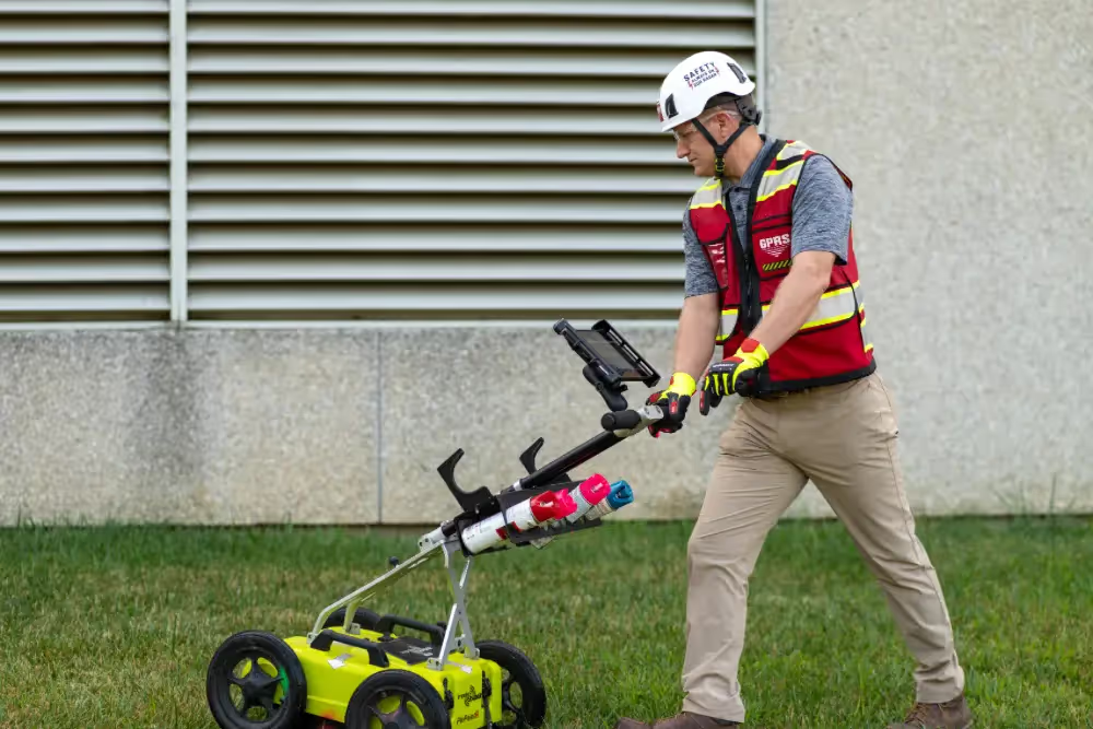
So, Fernandez instead turned to GPRS’ namesake technology: ground penetrating radar.
GPR scanners emit radio waves into the ground or a surface such as concrete, then detect the interactions between these signals and any subsurface obstructions such as buried utilities, embedded supports, or underground storage tanks (USTs).
Fernandez and his fellow GPRS Project Managers are specially trained to interpret the readouts from GPR scanners to determine where objects are buried and provide an estimated depth for these obstructions. In this residential neighborhood in San Pablo, Fernandez was able to use his GPR unit to find the stormwater system.
“I ended up seeing an anomaly with GPR, which led straight to the storm drain manhole which was clogged up,” he said. “The anomaly I found went straight through the middle of their work area... [So,] we saved the customer from hitting this storm line, which was in the trench path.”
During his investigation, Fernandez also found several other unknown utilities crossing the intended trench path. Had the contractor hit even one of these lines during trenching, they could have knocked out utilities to the surrounding neighborhood, and saddled themselves with costly utility repairs that would have delayed work and decimated their schedule and budget. And their workers, not to mention the residents of the neighborhood, could have been put in danger.
“The client was pleased that the storm drain and a few unknowns were found,” Fernandez said.

The data Fernandez collected was uploaded into SiteMap® (patent pending), GPRS’ project & facility management application that provides accurate existing conditions documentation to protect your assets and people.
Securely accessible 24/7 from any computer, tablet, or smartphone, SiteMap® is a single source of truth for the vital infrastructure data you and your team needs to plan, design, manage, dig, and ultimately build better. It eliminates the mistakes caused by miscommunications and streamlines the collaboration process for everyone involved in your projects.
The best part: every GPRS customer receives complimentary SiteMap® Personal access with every utility locate.
From storm drains to skyscrapers, GPRS Intelligently Visualizes The Built World® to keep your projects on time, on budget, and safe.
What can we help you visualize?
Frequently Asked Questions
What all do I get when I hire GPRS to conduct a utility locate?
Our Project Managers flag and paint our findings directly on the surface. This method of communication is the most accurate form of marking when excavation is expected to commence within a few days of service.
GPRS also uses a global positioning system (GPS) to collect data points of findings. We use this data to generate a plan, KMZ file, satellite overlay, or CAD file to permanently preserve results for future use. GPRS does not provide land surveying services. If you need land surveying services, please contact a professional land surveyor.
Please contact us to discuss the pricing and marking options your project may require.
What are the Benefits of Underground Utility Mapping?
Having an updated and accurate map of your subsurface infrastructure reduces accidents, budget overruns, change orders, and project downtime caused by dangerous and costly subsurface damage.