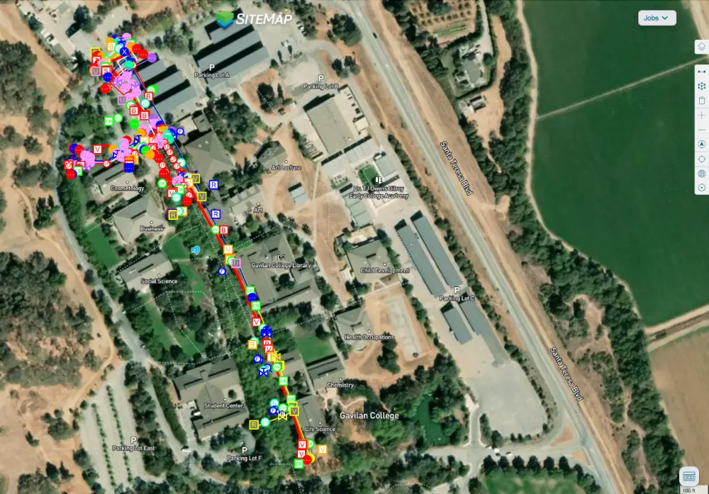
GPRS provided accurate utility locating and mapping services to help a contractor stay on time, on budget, and safe while installing water lines throughout a 150-acre community college.
GPRS Project Manager James Turrentine was contacted by Arizona Pipeline Co., which was installing the water lines across Gavilan College in Gilroy, California.

A Brief History of Gavilan College
The school was originally established in 1919 as San Benito County Junior College, with instruction offered at Hollister High School. It operated under this name until 1963, when a new community college district was drawn that included both San Benito and southern Santa Clara Counties. A local bond passed in 1966 which provided the funds necessary to construct the college’s current campus at Santa Teresa Boulevard in Gilroy.
Like many historic campuses across the country, Gavilan had no accurate existing as-builts to provide to Arizona Pipeline as the latter was preparing to trench to install the new water lines.

How GPRS Located the Water Line and Other Utilities
Arizona first contacted GPRS to locate a single existing water line on the campus.
GPRS provides precision utility locating services utilizing ground penetrating radar (GPR) and electromagnetic (EM) locating. GPR scanners emit radio waves into a surface or underground, then detect the interactions between the signals and any buried objects such as conduit, pipelines, or underground storage tanks (USTs). These interactions are displayed as a series of hyperbolas on a GPR readout, and GPRS Project Managers interpret this data to provide accurate location and depth data for these obstructions.
EM locators detect the electromagnetic signals radiating from metallic buried utilities, and as such are a perfect complement to GPR scanning. These signals can be created by the locator’s transmitter applying current to the pipe, or from current flow in a live electrical cable. They can also result from a conductive pipe acting as an antenna and re-radiating signals from stray electrical fields (detected by the EM locator functioning in Power Mode) and communications transmissions (Radio Mode).
Signals are created by the current flowing from the transmitter which travels along the conductor (line/cable/pipe) and back to the transmitter. The current typically uses a ground to complete the current. A ground stake is used to complete the circuit through the ground.
By utilizing both GPR scanning and EM locating, Turrentine was able to locate the buried water line for Arizona Pipeline. Not only did he mark out the location of the utility on the ground using flags and paint, but he also uploaded this data into SiteMap® (patent pending), GPRS’ intuitive, interactive utility mapping software application.
Securely accessible 24/7 from any computer, tablet or smartphone, SiteMap is the single source of truth a facility manager or general contractor needs to ensure their team can plan, design, manage, dig, and ultimately build better. It eliminates the mistakes caused by inaccurate/incomplete as-built documents and replaces them with the peace of mind that comes with knowing where all buried utilities are located – and therefore knowing where you can and can’t safely dig.
How a Water Line Locate Became a Full Site Utility Survey
When Turrentine showed his site contract with Arizona Pipeline the utility locating data he obtained and uploaded into SiteMap, the contact was so impressed that he asked GPRS to locate and map all the buried infrastructure across Gavilan College’s entire campus.
“[Turrentine] showed them in SiteMap their scope of work that they called us out there to do,” said GPRS Area Manager Jake Wright. “And [the client] said ‘Oh wow, we actually have hundreds of [utility] trenches we need to do. Could we do the whole campus like that?’ And Turrentine said ‘Yeah, totally.’”
While every GPRS customer receives complimentary SiteMap Personal access to view the data we collect for them, the platform can be tailored to meet your individual needs. Arizona Pipeline received SiteMap Project access so that their entire team would have access to the accurate, field-verified data collected on-site by Turrentine throughout their project’s lifecycle.
From college campuses to skyscrapers, GPRS Intelligently Visualizes The Built World® to keep your projects on time, on budget, and safe.
What can we help you visualize?
Frequently Asked Questions
What informational output do I receive when I hire GPRS to conduct a utility locate?
Our Project Managers flag and paint our findings directly on the surface. This method of communication is the most accurate form of marking when excavation is expected to commence within a few days of service.
GPRS also uses a global positioning system (GPS) to collect data points of findings. We use this data to generate a plan, KMZ file, satellite overlay, or CAD file to permanently preserve results for future use. And all this accurate-field-verified data is uploaded into SiteMap®, so you and your team have secure, 24/7 access.
GPRS does not provide land surveying services. If you need land surveying services, please contact a professional land surveyor.
Please contact us to discuss the pricing and marking options your project may require.
Can ground penetrating radar find PVC piping and other non-conductive utilities?
GPR scanning is exceptionally effective at locating all types of subsurface materials. There are times when PVC pipes do not provide an adequate signal to ground penetrating radar equipment and can’t be properly located by traditional methods. However, GPRS Project Managers are expertly trained at multiple methods of utility locating.
