The process of utility locating involves identifying and mapping underground utilities such as gas lines, water pipes, electrical cables, telecommunication lines, and sewer lines before excavation or construction. Mapping utility locations ensures safety on the construction site, prevents service disruptions, and avoids costly damage to utilities.
The utility locating process typically follows these steps:
1. Request Existing Utility Records
- Request maps, as-built drawings, and utility records from municipalities, utility companies, local government, public records, engineering firms, or facility managers.
- Review historical data to identify known utility locations.
2. Perform a Site Survey
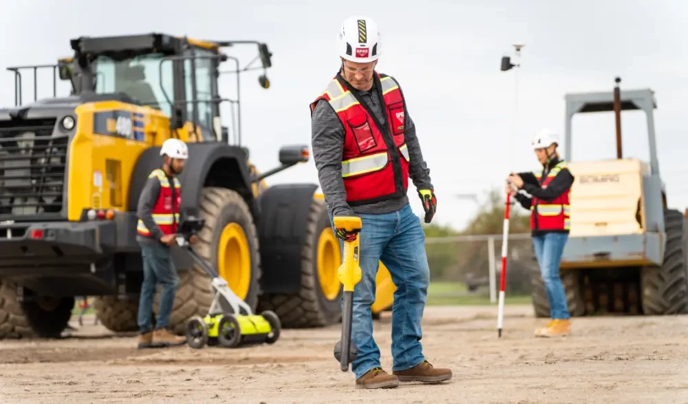
- If you are planning on digging (on private or public property), you are required by law to contact 811 before you break ground to request a utility locate.
- 811 will contact the utility owner who usually partner with a subcontractor to locate and mark 811-registered public utilities.
- Public utility locating via 811 centers is a free service in the U.S., but 811 centers can only contact registered utility owners to mark their utility lines prior to excavation. Their mission does not extend to notifying owners of unregistered or privately-owned utilities.
- You should also employ a private utility locating service such as GPRS to ensure that there are no private utility lines where you’re intending to dig.
- A trained utility locating technician performs locates for all non-public buried assets. With a nationwide team of elite Project Managers strategically stationed across the country, GPRS ensures you always have a qualified utility locating professional near you.
3. Select Utility Locating Methods
Technicians use specialized equipment to detect and mark underground utilities. The utility locating process utilizes the following equipment:
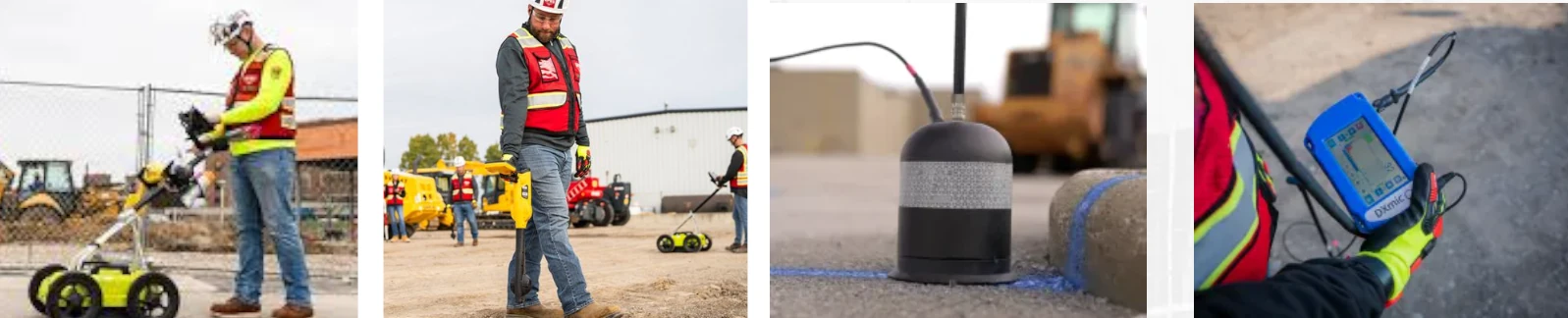
- Ground Penetrating Radar (GPR): GPR is a non-destructive technology which sends radar pulses into the ground and creates images of subsurface features. It can identify all types of underground utilities and can scan for voids, rebar, conduit, post tension cables, and other structural elements hidden within concrete.
- Electromagnetic Locators: An EM locator is a device used to locate and trace buried metallic utility lines, such as pipes and cables, by using electromagnetic signals. An EM locator can trace the following buried metallic utility lines – electrical cables, telecommunication & fiber optic cables (with tracer wire), metallic gas pipelines, metallic water supply lines, sewer lines & storm drains, and metal pipes used in irrigation systems.
- Acoustic Locators: Acoustic locating detects underground water leaks and traces buried pressurized pipes by analyzing sound waves and vibrations. Specialized sensors and ground microphones amplify these sounds, helping technicians pinpoint leaks and trace non-metallic pipes, such as PVC or HDPE, which do not conduct electromagnetic signals.
- Magnetic Locators: Magnetic locators find buried iron or steel objects such as cast iron or steel water pipes, valve boxes, manhole covers, and other buried infrastructure.
4. Mark Out Utilities
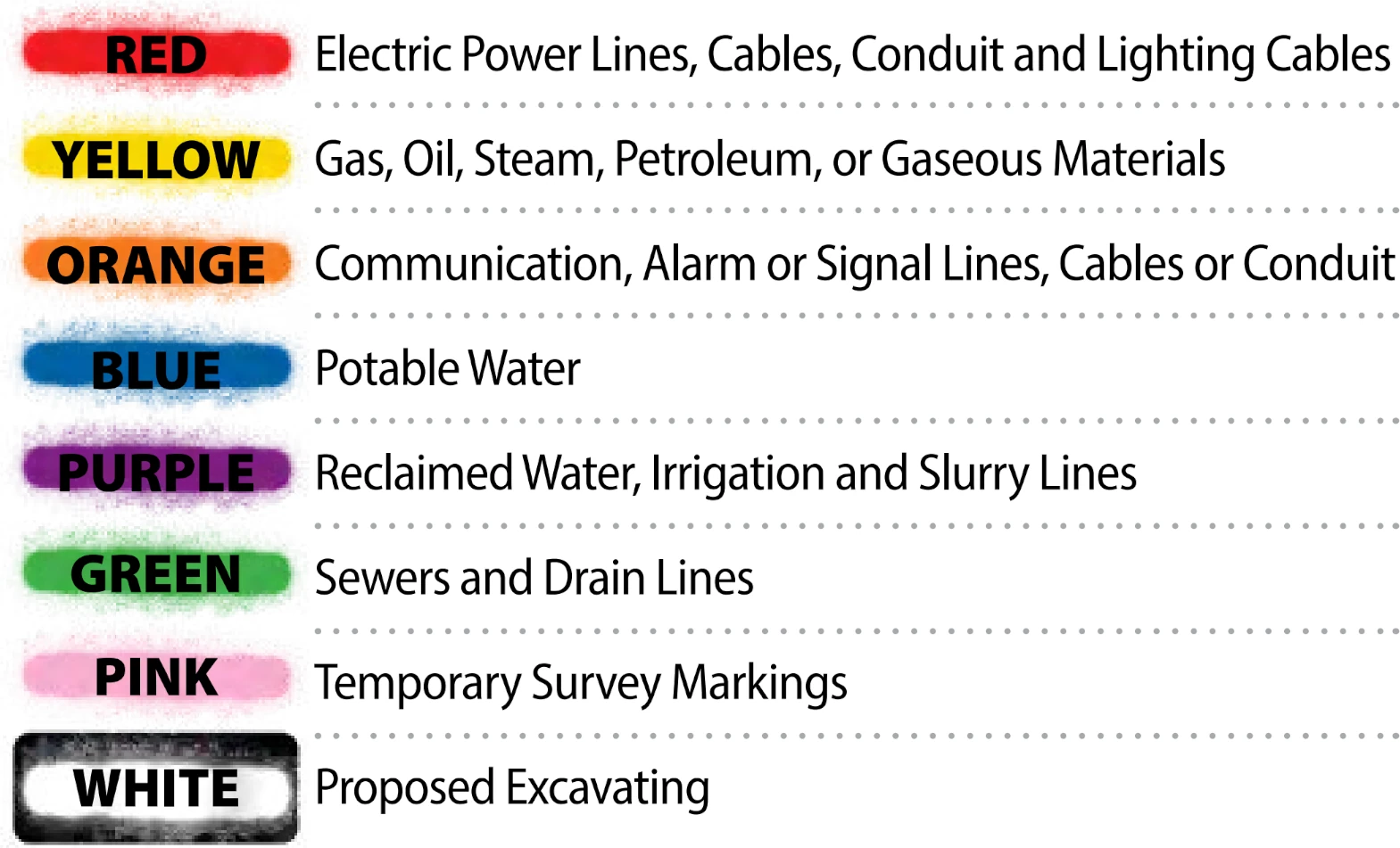
- Utilities are marked on the ground using standardized color codes and symbols to indicate the type and location of buried infrastructure.
- After a utility locating service identifies underground pipes, cables, or conduits, they use spray paint, flags, or stakes to mark their positions.
- Markings often include symbols, letters, or numbers to indicate utility depth, pipe size, or ownership. These ground markings help contractors avoid damage to buried utilities, ensuring safe excavation and construction activities.
- The American Public Works Association (APWA) has established a universal color code to differentiate various utilities:
- Red – Electric power lines, cables, and lighting cables
- Orange – Communication, alarm, signal lines, and fiber optic cables
- Yellow – Gas, oil, steam, petroleum, and other flammable materials
- Green – Sewer and drain lines
- Blue – Potable (drinking) water
- Purple – Reclaimed water, irrigation, and slurry lines
- Pink – Temporary survey markings
- White – Proposed excavation area
5. Verification and Depth Estimation
- Some projects require additional verification through vacuum excavation or potholing, where small holes are dug to confirm depth and location.
- Utility depths are estimated based on signal strength and GPR reflections.
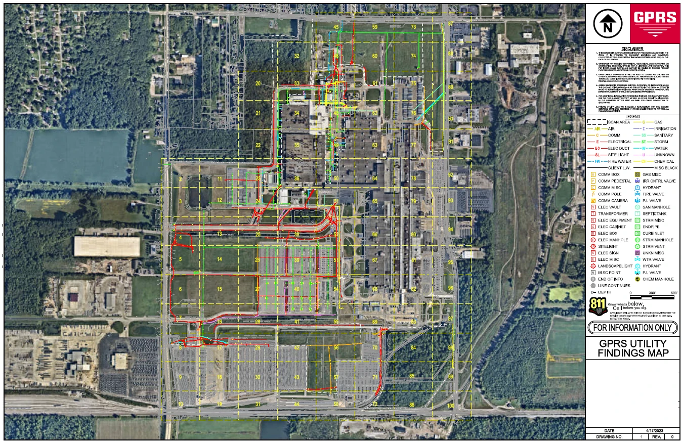
6. Map Utilities in CAD and BIM
- The utility marking field data includes precise spatial coordinates, depths, types of materials, and other attributes. Once collected, this data is typically processed in GIS (Geographic Information Systems) software to organize and visualize the information.
- There are several GIS companies that help clients map their infrastructure; they all share one key challenge: the system is only as accurate as the data entered into it.
- The effectiveness of any GIS system hinges on the quality of the data it uses. If the input data is inaccurate, incomplete, or outdated, the resulting maps and analyses will also be flawed.
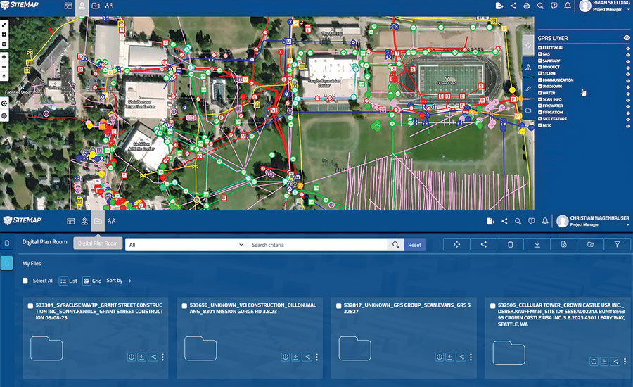
- SiteMap® powered by GPRS, is built on accurate, real-world data collected directly from the jobsite by GPRS’ highly trained Project Managers, all of whom are NASSCO and SIM-certified.
- Geospatial data can be exported into precise 2D utility maps in AutoCAD, Civil 3D, or MicroStation formats. Color coding is applied and mapped following the APWA utility marking standards mentioned above for clear visualization.
- AutoCAD: Used for creating accurate 2D utility layouts, AutoCAD is widely accepted in architecture, engineering, and construction. The utility lines, symbols, and annotations can be placed on standardized layers for easy reference and integration into larger site plans.
- Civil 3D: This is a more advanced version of AutoCAD tailored for civil infrastructure projects. Civil 3D allows the geospatial data to be integrated with topography, corridors, and other site design elements, making it ideal for clash detection, grading, and pipe network design.
- MicroStation: Used commonly in DOT and large infrastructure projects, MicroStation supports similar functionality and precision as AutoCAD, enabling teams to visualize utility data in highly regulated formats.
- Each utility is georeferenced to real-world coordinates and organized into standard layering conventions (e.g., separate layers for water, gas, electric, sewer, and telecom).
- Many GPS and GNSS receivers utilize RTK GPS coordinates to achieve a greater degree of positioning accuracy.
- Standard GPS typically offers 1–5 meter accuracy, which is fine for general use but not reliable for precision work like utility locating.
- RTK GPS, on the other hand, uses real-time corrections to achieve centimeter-level accuracy—ideal for surveying, utility locating, and mapping underground infrastructure.
- Because RTK's geolocation is more accurate than a standard satellite image, the actual location of your utilities may not line up with where you expect to see them on the map; not because the utilities are mismarked, but because the utility data has been more accurately captured than the satellite image.
- A 3D BIM model can be generated in software like Revit or Civil 3D, including elevation and depth attributes, for detailed visualization and clash detection.
- As-built utility data can be aligned with site plans, survey data, and as-built drawings.
- By converting GIS geospatial data into CAD and BIM formats, clients get precise, scalable, and easily editable documentation, ensuring safer excavations and more efficient design coordination.
GPRS’ SiteMap® Software Platform
SiteMap® (patent pending), powered by GPRS, is a cloud-based infrastructure mapping application that features GIS functionality, and is able to support data portability for your existing GIS platform of choice
What sets GPRS’ SiteMap® apart from other GIS platforms is its foundation: it's built on accurate, real-world data collected directly from the jobsite by GPRS’ highly trained Project Managers, all of whom are NASSCO and SIM-certified.
Unlike traditional GIS systems that rely on potentially outdated or inconsistent third-party data, SiteMap® is powered by precise field data gathered through advanced utility locating, CCTV sewer inspections, and 3D laser scanning.
This verified data is then processed, layered, and modeled by GPRS’ in-house Mapping & Modeling Department to create clear, customized visuals that align with your project requirements. The result is a secure, cloud-based GIS platform that gives you confidence in your infrastructure data—enabling faster decision-making, safer excavation, and better long-term asset management.
Why Utility Locating Matters
- Prevents costly damages to underground infrastructure.
- Enhances worker safety by avoiding hazardous gas or electrical line strikes.
- Ensures regulatory compliance and prevents legal liabilities.
- Reduces project delays by avoiding unexpected underground obstructions.
By following a thorough utility locating process, construction teams can proceed safely and efficiently without costly or dangerous interruptions.
Why Choose GPRS?
GPRS excels in utility locating because our Project Managers utilize advanced GPR and EM locating technologies, coupled with industry-leading training and methodologies, to achieve 99.8% accuracy in identifying and mapping underground infrastructure.
Our 99.8% accuracy rating is made possible by our elite team of Project Managers who use advanced tools to ensure compliance with Subsurface Investigation Methodology (SIM) standards. SIM focuses on training, equipment expertise, and best methodology practices to safeguard underground assets, limit structural damage, and increase contractor accountability.
GPRS clients are guaranteed reliable utility locating services and the assistance of a Project Manager who provides real-time accurate data in SiteMap®. GPRS clients get a powerful, visual tool that bridges field conditions and office-based design—streamlining workflows from discovery to delivery.
With GPRS, you'll Intelligently Visualize The Built World™ by mapping your subsurface infrastructure to identify potential site issues and risks.
What can we help you visualize?
Frequently Asked Questions
How much does utility locating cost?
The cost of a private utility locate varies depending on the size and specifics of the site being scanned, as well as other factors. Utility locates are not cheap, but as mentioned above they are a vital service and significantly less expensive than the cost – both financial and otherwise – of striking a utility line.
What types of utilities can be located?
Electric, steam, telecommunications, water pipes, gas & oil pipes, sewer pipes & storm sewer lines, and many other primary and secondary utility services can be located.
Does GPRS offer same day private utility locating?
Yes, our professional Project Managers can respond rapidly to emergency same-day private utility locating service calls on your job site.