It’s exciting to see adaptive reuse being embraced in the construction industry, as lifeless buildings are transformed into functional, sustainable, and vibrant spaces.
Adaptive reuse is the process of repurposing unused buildings instead of demolishing them. It involves renovating existing structures into a useful building, while preserving their historical and architectural features. There has also been a rise in adaptive reuse to convert outdated office space to other potential uses. Adaptive reuse is often seen as a sustainable approach to building development, as it can help reduce waste, preserve architectural heritage, and revitalize communities.
Pandemic shut-downs changed how many businesses thought of their workforce and office needs, leaving many unoccupied buildings in cities across the country. With an increase in professionals working remotely, the United States has seen an increase in available, affordable office, retail, and warehouse space in urban areas. These spaces become the heart of adaptive reuse projects, for example, converting old factories into loft apartments, turning churches into restaurants, transforming warehouses into office spaces, and turning unused office buildings into data centers.
Commercial real estate developers are exploring more adaptive reuse projects because they have the financial means and construction expertise required to renovate these structures successfully.
How is a Building Assessed Before Adaptive Reuse Renovations?
The developer will hire an architect with expertise in the type of project they are working on, for example, a tenant improvement or development project.
The architect will conduct a building assessment when redesigning an adaptive reuse building to ensure that the existing structure is transformed into a functional, safe, and aesthetically pleasing space.
According to Utilities One Engineering Inspections, skipping a formal building assessment could save on project costs, but it can lead to unnecessary hidden costs and even dangerous workplaces if the building isn’t structurally sound.
The architect’s assessment typically includes the following:
- Conducting a structural analysis to determine if any modifications or reinforcements are needed to support the new building’s use
- Ensuring that the building complies with codes and standards, including ADA accessibility standards
- Identifying any historical or cultural preservation constraints and zoning laws
- Evaluating the existing MEP systems to determine if they need to be upgraded or replaced to meet the needs of the new construction
Once the assessment is complete, an architect will begin renovation design planning, spec the materials, and oversee the construction process.
An adaptive reuse project will require collaboration between developers, architects, engineers, and contractors to ensure that all requirements can be satisfied within the existing structure.
How Does the Architect Plan the Building Renovation?
The architect will typically not have documents that show the construction of the existing building. They will hire a company to 3D laser scan the building to create accurate as builts for virtual design and construction. Precise building details are needed to create design models and make sure no unforeseen issues arise during building renovations.
GPRS 3D laser scanning services quickly and accurately provide comprehensive as built documentation of a building, unmatched by other technologies. From walls and windows to HVAC, mechanical, electrical, and plumbing features, GPRS can accurately identify and document all visible elements of a structure. GPRS 3D laser scanning services will let the architect focus on design, rather than verifying the existing building conditions.
The GPRS Mapping & Modeling team can transform the point cloud data captured by the 3D laser scanner into a 3D building information model (BIM). GPRS delivers the as-built model via SiteMap®, a cloud-based software that will allow the architect and project team to view and securely share project data from any computer or mobile device.
The BIM model will allow the architect to explore design options and communicate the vision of the project. It can help the architect iterate and refine design changes in a virtual environment and deliver innovative solutions for adaptive reuse and retrofit projects.
With accurate data, the architect can determine what elements they will reuse and what materials will need to be renovated, from the roof to the doors, windows, and walls. The architect will use the BIM model to prepare detailed construction plans to specify the structural layout, MEP system layout, materials, and finishes. They can deliver a detailed design plan to the VDC team and contractors to receive accurate timelines and cost estimates.
Further, they can create floor plans and virtual tours of the built environment from the BIM model to communicate the building layout. A virtual tour allows the team to tour the renovation plans, add digital notes, and even measure inside the 3D model.
BIM allows the architect to collaborate and coordinate with the VDC team and contractors during construction. They can review the building design, coordinate trades, reduce errors, increase safety, and optimize project efficiency.
3D Laser Scanning to Convert a Historic Building to a Luxury Hotel
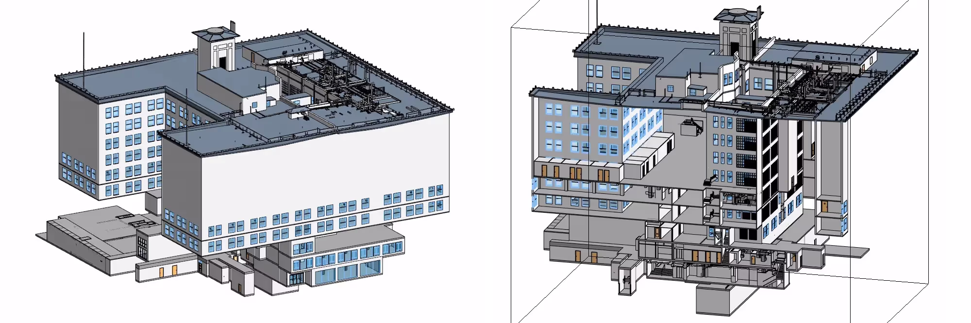
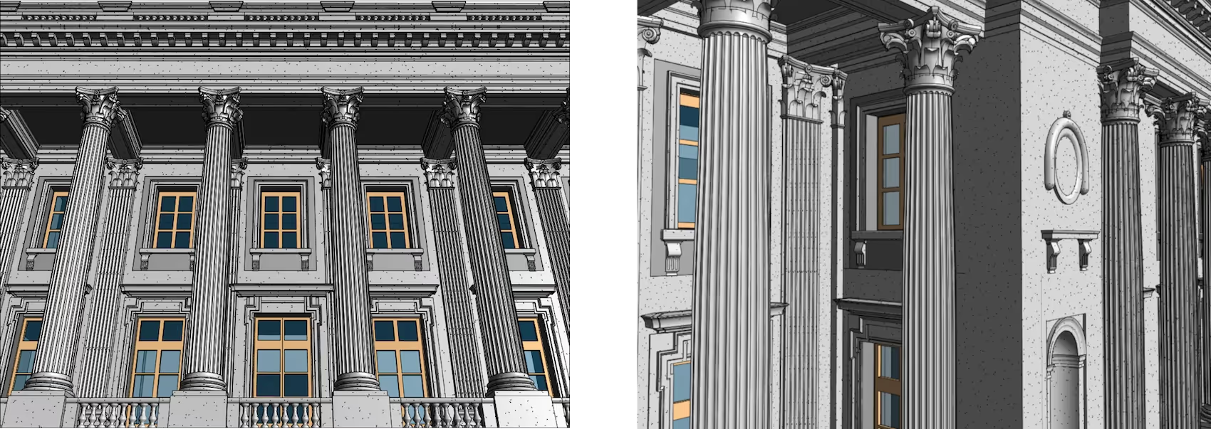
GPRS was hired to perform 3D laser scanning services to aid an architect in converting a historic building in Philadelphia into a luxury hotel. The architect required highly detailed architectural data including walls, ceilings, floors, stairs, balustrades, colonnades, etc., and structural data including exposed columns and beams to design the renovation.
GPRS captured precise details of the 250,000 square-foot building, including the exterior facade, floors 1-4, basement, roof, penthouses, and mechanical spaces. A 3D Revit model with varying degrees of LOD 200 and LOD 300 modeling was generated by the GPRS Mapping & Modeling team based on the architect’s requirements.
“The point cloud and 3D model worked out tremendously well. This was almost the perfect project to use it on due to the various intricacies of the building layout and large differences from floor to floor. “ - N. Pellizzari, Architecture & Planning Professional
How Can GPRS Help with Adaptive Reuse?
GPRS 3D laser scanning services provide architects with powerful 3D BIM models to design adaptive reuse and retrofit projects. They can experiment with different building aesthetics, functionality, and sustainability plans in a virtual environment.
GPRS deploys highly trained Project Managers equipped with the most advanced laser scanning technology to capture the exact dimensions and measurements of your project site.
The GPRS Mapping & Modeling Team delivers precise point cloud data, 2D CAD drawings, and 3D BIM models to improve the collaboration and coordination of your project.
Few 3D laser scanning companies have the experience, state-of the art technology, and nationwide presence as GPRS. See how GPRS can Intelligently Visualize Your Built World™, with accurate data to renovate buildings and eliminate project risks, change orders, delays, and costs.
What can we help you visualize?
Frequently Asked Questions
What is 3D Laser Scanning?
3D laser scanning captures as built documentation for existing buildings or sites. Once data is acquired, a point cloud is generated and used to develop 2D CAD drawings or 3D BIM models, expediting the design, planning, and development of projects.
How Does Laser Scanning Work?
One primary method is that a laser scanner sends light pulses at high speeds which reflect off objects and return to the scanners’ sensor. For each pulse, the distance between the scanner and object is measured by determining the elapsed time between the sent and received pulses. Each point of the scan will be converted to a pixel with a known x-, y-, and z- coordinate. Laser scans or LiDAR scans are taken in multiple positions around a site from varying viewpoints. Millions of data points are captured and processed into a point cloud, creating an accurate data set of the structure or site.
Why is a Point Cloud Important?
Point clouds provide powerful and dynamic information for a project. By representing spatial data as a collection of coordinates, point clouds deliver large datasets that can be mined for information. The visualization and analysis from this data is invaluable for decision making. CAD technicians transform point clouds into customized maps and models used for visualization, analysis, design, construction, renovation, prefabrication, and facility modifications.
What are the Benefits of 3D Laser Scanning?
With 3D laser scanning services, sites are captured in high detail the first time, eliminating the need for return visits. High speed data collection expedites time-sensitive projects or those that require minimal disruption. Datasets are dimensionally accurate, measurable, and shareable, optimizing the efficiency of time spent during project planning and execution. Communication is improved, teams can discuss plans while each has access to the same information, creating a more dynamic working environment.
How Long Does Laser Scanning Take?
With Project Managers all over the US, we work quickly to provide detailed quotes for clients. For most jobs, large areas can be laser scanned in as little as a couple of hours or larger sites in as little as a few days. Entire facilities or campuses can take several weeks to capture the entire site, but most projects are measured in hours or days.