GPRS concrete imaging and 3D laser scanning services provided accurate existing conditions documentation prior to extensive renovations at one of the largest resort casinos in the United States.
Pechanga Resort Casino in Temecula Valley, California was preparing to renovate parts of its hotel, event spaces, and ballrooms.
The contractor working with Pechanga on its renovations would be cutting and coring into elevated concrete slab. They needed to obtain accurate data about the layout of post tension cable, rebar, stud rails, and conduits, so they could avoid all these reinforcements and prevent costly – and potentially dangerous – subsurface damage.
The catch was that the event spaces needed to remain operational during any investigations of the slab.
“They would be needing to use these event spaces and could not have markings down on the ground,” explained GPRS Area Manager David Henneman. “This gave us a limited window to collect/perform the work, and without having the marks remain on the ground there would be very little value to the client.”
Fortunately, GPRS’ comprehensive suite of subsurface damage prevention, existing conditions documentation, and construction & facilities project management services enable us to find creative solutions to our client’s unique problems.

Project Managers Armando Martinez, Jesse Radilla, Steven Gomez, Mazi Richburg, Mario Poblete, and Mike Abel first conducted our standard concrete scanning services using ground penetrating radar (GPR) scanners. This non-destructive imaging technology emits radio waves into a concrete slab, then detects the interactions between those signals and any embedded objects such as rebar, post tension cable, or conduit.
The interactions between the signals and the buried objects are presented in a GPR readout as a series of hyperbolas that vary in size and shape depending on what was located. GPRS’ Project Managers interpret this data to tell you what was found and provide the estimated depth that those items are buried.
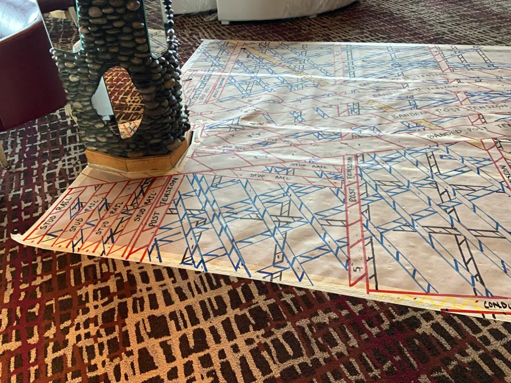
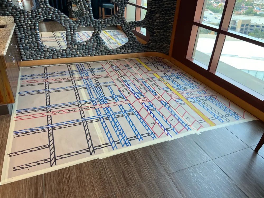
Because Pechanga did not want any permanent markings left in their event spaces, the Project Managers marked out their findings on heavy-duty, temporary floor protection which they had laid over the floor prior to scanning.

The Project Managers then documented their findings with 3D laser scanners. They also scanned the interior spaces that would be renovated, to provide additional data that would prove invaluable during planning and design.
GPRS 3D Laser Scanning Services quickly and accurately document buildings and infrastructure with Leica laser scanners to deliver LiDAR point clouds, 2D CAD drawings, and 3D BIM models that expedite project planning and execution.

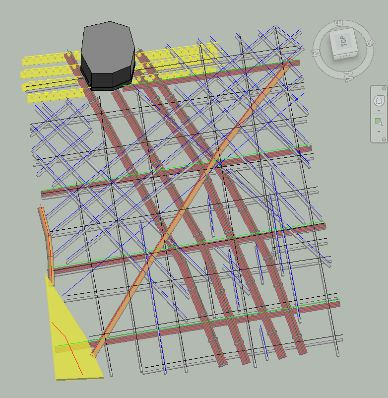
Through the combination of concrete imaging and 3D laser scanning, Pechanga Resort Casino ultimately received a 3D model of the spaces they were planning to renovate, along with 2D CAD drawings of the concrete scanning markings, and a 3D at-depth model of the concrete slab.
“We took this as an opportunity to introduce the use of laser scanning and a 3D model to preserve the findings in an accurate digital twin,” Henneman said. “The scope was originally just scanning areas for items within the elevated concrete deck but ultimately evolved into a laser scan with a full 3D model with rebar, conduits, and post tension modeled at depth.”
Henneman said that the team discovered an extraordinary number of conduits embedded within the slab. Had the contractor not had an accurate map of these conduits, they and their team would have been in danger of damaging one of these lines and electrocuting themselves.
“We knew there were conduits in the slab, but the amount we found was surprising,” Henneman said.
The data collected by GPRS allowed Pechanga Resort Casino to safely and efficiently plan and execute their renovations.
From skyscrapers to sewer lines, GPRS Intelligently Visualizes The Built World® to keep your projects on time, on budget, and safe.
What can we help you visualize?
Frequently Asked Questions
Is 3D laser scanning right for my project?
Almost any project that requires as-built information can benefit from a laser scanning survey. Talk with our experts and start your 3D laser scanning survey project today.
Can ground penetrating radar determine the difference between rebar and electrical conduit?
Ground penetrating radar (GPR) can accurately differentiate between rebar and electrical conduit in most cases. We have an extremely high success rate in identifying electrical lines in supported slabs or slabs-on-grade before saw cutting or core drilling.
Additionally, GPRS can use electromagnetic (EM) locators to determine the location of conduits in the concrete. If we can transmit a signal onto the metal conduit, we can locate it with pinpoint accuracy. We can also find the conduit passively if a live electrical current runs through it.
The combined use of GPR and EM locating allows us to provide one of the most comprehensive and accurate conduits locating services available.
What is a digital twin?
A digital twin is highly complex virtual model that is the exact counterpart (or twin) of a physical object. GPRS uses 3D laser scanners to collect real-time data for a building or facility and create a digital duplicate. Data can be easily visualized, measured and analyzed. Digital twins can be used to improve efficiencies, optimize workflows and detect problems before they occur.
What’s the difference between design intent and as-built documentation?
DESIGN INTENT – deliverables will be shown as a "best fit" to the point cloud working within customary standards, such as walls being modeled 90 degrees perpendicular to the floor, pipes and conduit modeled straight, floors and ceilings modeled horizontal, and steel members modeled straight. This will produce cleaner 2D drawings and will allow for easier dimensioning of the scan area. The deliverables will not exactly follow the scan data to maintain design intent standards. Most clients will want this option for their deliverables.
AS-BUILTS – deliverables will be shown as close as possible to actual field capture. If walls are out of plumb, pipes and conduit show sag, floors and ceilings are unlevel, steel members show camber, etc., this will be reflected in the model. This will produce reality-capture deliverables, but 2D drawings may show “crooked” or out of plumb lines, floors will be sloped or contoured, steel members may show camber, twisting or impact damage. Dimensioning will not be as easy due being out of plumbness/levelness, etc. This option should be used when the exact conditions of the scan area is imperative. Clients using the data for fabrication, forensic analysis, bolt hole patterns, camber/sag/deformation analysis, and similar needs would require this option.
