When you have a project 3D laser scanned, there are many possible deliverables and file formats to choose from. Selecting the right 3D laser scan output type can be a daunting task.
GPRS is the only 3D laser scanning company with a nationwide U.S. footprint, so we are familiar with fielding requests from the architecture, engineering, and construction industries, among others. And every job has its own particular requirements.
That’s why we strive to tailor the best CAD, BIM, digital twin, point cloud, or 3D virtual tour solutions for our customers’ needs.
The first step is for you to determine the purpose of the 3D laser scan and the software you'll be using, for example do you want CAD drawings, a 3D BIM model, or a 3D virtual tour?
Below, you can explore the wide range of detailed and accurate deliverables that 3D laser scanning can provide, helping you bring your projects to life with precision and efficiency.
What are the Deliverables After 3D Laser Scanning?
Point Cloud
A point cloud is the collection of millions of data points, captured with a 3D laser scanner, that represent the scanned surface or object, each containing an X, Y, and Z coordinate. The point cloud records a digital 3D representation of the scanned environment, capturing geometry, spatial relationships, and physical features. You can import the point cloud into CAD or BIM software to visualize the area as a pixelated, digital version of your site. Point clouds can be processed and used for measurement, analysis, and visualization.
Deliverable: Raw Point Cloud Data or Registered Point Clouds.
File Formats: .e57, .LAS, .LAZ, .XYZ, .PTS point cloud files and Autodesk Recap files in .RCS and .RCP format.

2D CAD Drawings
A 2D CAD drawing is a flat, digital representation of an object or structure created using CAD software. It displays views from different angles, such as top, front, or side, using geometric shapes, lines, arcs, and text to show size, shape, and layout. Point cloud data is imported into AutoCAD to generate 2D CAD drawings, where technicians can document and annotate them with text, dimensions, leaders, and tables.
Deliverable: Floor plans, site plans, elevations, sections, details, isometric drawings, and reflected ceiling plans.
File Formats: 2D sheets in .RVT, .DWG, .DGN, .DXF or .PDF formats.
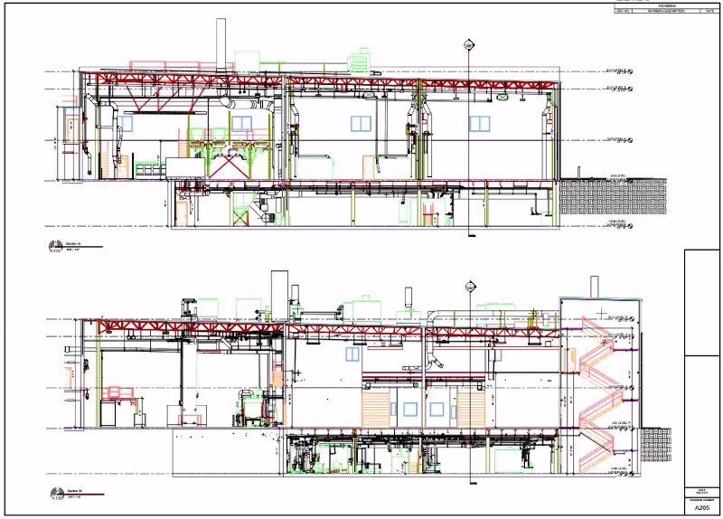
3D BIM Model
A 3D BIM model is a digital representation of a building that integrates geometry, spatial relationships, and detailed data about its components. Created using BIM software like Revit, the model provides an accurate, intelligent, and dynamic 3D virtual model for design, construction, and facility management. A 3D BIM model includes information on structural elements, MEP systems, materials, and can also include cost and scheduling data. 3D BIM models provide users with the ability to break down building parts by elements or layers and see how they fit into a single finalized structure. For example, users can isolate walls, columns, windows, doors, etc., and alter the design.
Deliverable: 3D BIM Model
File Formats: 3D models in software such as Revit, AutoCAD, ArchiCAD, MicroStation, SolidWorks, Navisworks in .RVT, .NWD, .IFC, .BCF file formats.
Modeling Options: Standard Detail, High Detail, Very High Detail.

3D Mesh Model
Highly detailed 3D laser scan data can be converted into 3D mesh files, such as .fbx, .stl, .obj, and .ply, for use in CAD or surfacing software. Using x, y, z coordinates, CAD technicians can generate a triangulated mesh from the point cloud, creating a volumetrically accurate, high-density, and high-resolution model. This mesh allows clients to easily view the geometry of objects in CAD without navigating the point cloud. Meshes are ideal for representing intricate details, like monuments or statues, and can be used for creating mixed reality experiences, such as those in stadiums during sporting events.
Deliverable: Polygonal Mesh.
File Formats: .FBX, .STL, .OBJ, and .PLY.

TruView
A TruView is a high-resolution panoramic image that can be overlayed on top of the point cloud, making it easier to understand the spatial relationships within the scanned area. Since TruViews are overlaid on the point cloud data, clients are able to take basic dimensions directly from the Viewer for estimating clearances, and distances, etc. It allows users to easily share, annotate, and view detailed 3D laser scan data for decision-making.
Deliverable: Autodesk TruView portable software allows you to open and view the LGS format of the point cloud, as well as overlay IFC (3D model) files.
File Formats: TruViews can be delivered as a .LGS or .LGSX but a structured .RCP will also have images so an end user with point cloud software can navigate this file format similar to a TruView virtual tour.

3D Virtual Tour
A 3D Virtual Tour consists of a series of 360° panoramic images stitched together to create a complete, interactive view of a location. This tool allows your team to virtually explore the space and add digital notes, providing a detailed and immersive experience. The 3D Virtual Tour can be accessed on desktop computers, laptops, tablets, and mobile devices for easy viewing from anywhere.
Deliverable: 360° panoramic images, plus a customizable .LGSx point cloud data file format.
File Formats: .LGSx or a browser based virtual tour via Benaco or Matterport.

Subsurface Utility Map
A subsurface utility map is a visual representation of underground utilities, such as water, gas, electrical, telecommunications, and sewer lines, typically created using data from Ground Penetrating Radar (GPR) and Electromagnetic (EM) Locating technology, 3D laser scanning, and GIS systems. The map helps engineers, contractors, and planners identify the location and condition of these utilities to avoid damage during construction or excavation.
Deliverable: Standard CAD Site Plan, Interactive Site Plan in SiteMap®, 3D BIM or Conceptual Site Models (CSM).
File Formats: PDF file, KMZ file, and SiteMap Personal Access.
- PDF File: A subsurface utility map in PDF format is a static document containing the visual representation of utilities, typically designed for easy viewing and sharing. It includes layers showing the location of pipes, cables, and other underground infrastructure, often with annotations and measurements.
- KMZ File: A KMZ file is a compressed format for geospatial data that stores georeferenced maps. In subsurface utility mapping, it can be viewed in Google Earth or GIS software, allowing for 3D visualization and precise location data to integrate underground utilities with surface maps.
- SiteMap® Personal Access: Digital utility maps are uploaded in SiteMap® GPRS’ free cloud-based software, providing quick access and secure sharing of detailed, geolocated, and layered underground utility maps. The GPRS Mapping & Modeling Team can generate TruBuilt plan views and 3D BIM or Conceptual Site Models (CSM) for better project or facility management.

Tank & Vessel Inspections
3D laser scan data delivers accurate data and a highly detailed analysis when evaluating the condition and integrity of tanks and vessels. A LiDAR point cloud is processed and compared against a CAD/BIM drawing/model or previous scan data to detect deformations, corrosion, weld inconsistencies, and deviations from design specifications. Advanced software generates color-coded deviation maps, cross-sectional analysis, and precise dimensional measurements, allowing engineers to assess structural integrity and compliance with industry standards such as API 653, ASME, or ASTM. This level of detail helps in predictive maintenance, ensuring early detection of potential failures, minimizing downtime, and optimizing repair planning.
Deliverable: Point clouds, 2D CAD drawings, 3D BIM models.
File Formats: .PPT, .PDF, Excel, .XML.

Deformation and Inspection Reports
Deformation and Inspection Reports from 3D laser scanning provide detailed analysis of structural changes, irregularities, or defects in physical objects or environments. Using the precise data captured by the laser scanner, the report compares the scanned point cloud data against a reference model (such as a CAD or BIM file) to identify deviations in shape, alignment, and size. These reports can detect issues such as settling, warping, misalignment, and corrosion in structures, or inconsistencies in manufacturing parts. The output typically includes color-coded deviation maps, dimensional measurements, and detailed annotations, helping engineers and contractors assess the condition of a structure or component, plan for maintenance, and ensure quality control.
Deliverable: Deformation and Inspection Reports.
File Formats: PDF, .RCS, .RCP, .DXF, .DWG, .STL, .OBJ.

Photogrammetry Matterport Pro 3
While the Matterport Pro3 is not a laser scanner, it is equipped with a 30-megapixel sensor and 12-element lens camera, plus LiDAR technology, allowing you to create walkthroughs, 3D tours, digital twins, 3D models, point clouds, floor plans, schematic maps, and professional quality 2D still capture output of physical spaces, with the ability to edit and share them using the Matterport app and digital twin technology cloud service.
Deliverable: Virtual tours, digital twins, point clouds, layouts, floorplans, schematic maps, and more.
File Formats: .JPG, .e57, .DWG, .DXF, .PDF, .RCS, .CTB, .RVT, .IFC, .OBJ.

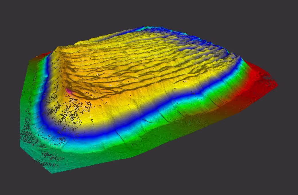
Topographic or Aerial Maps
A map or model of the terrain, showing the shape of the land and its elevations and contours, often in the form of 2D or 3D representations.
Data Type: Elevation data, contour lines, spatial coordinates.
File Formats: .PDF, .DXF, .DWG, .SHP, .GeoTIFF, .KML.
Orthomosaic Image
A high-resolution, geometrically corrected aerial image composed of multiple stitched-together photos. It is distortion-free and maintains uniform scale, making it ideal for visual inspection, documentation, and 3D modeling.
Data Type: 2D raster image, high-resolution aerial photos.
File Formats: .TIFF, .JPEG, .PNG, .ECW, .SID.

Orthomosaic Map
A geo-referenced orthomosaic image of topography, infrastructure, and buildings integrated with real-world coordinates and spatial data, often used in GIS (Geographic Information Systems). It allows for precise measurements, analysis, and mapping applications in construction, land surveying, and environmental monitoring.
Data Type: Georeferenced raster data with spatial coordinates and topographical features.
File Formats: .GeoTIFF, .KML, .SHP, .DWG, .DXF.

Digital Elevation Model (DEM)
A general term for a 3D representation of the Earth's surface, typically focusing on elevation data. It captures the height of land surfaces above a reference point, usually sea level, and may include natural features, such as hills as well as man-made structures, such as buildings or roads. DEMs are commonly used in topographic analysis, flood modeling, and terrain analysis.
Deliverable: A 3D model or map that represents terrain elevation and surface features.
Data Type: Elevation data in a raster format.
File Formats: .TIFF, .GeoTIFF, .ASCII, .DEM, .IMG, .XYZ.

Digital Surface Model (DSM)
A DSM represents the Earth's surface, but it includes both natural and artificial objects, such as trees, buildings, and other structures. This model captures the elevation of the highest points, making it useful for urban planning, forestry, and line-of-sight analysis.
Data Type: Raster-based surface data with topographic and structural features.
File Formats: .TIFF, .GeoTIFF, .ASC, .DSM, .LAS.

Digital Terrain Model (DTM)
A DTM is a more refined version of a DEM that focuses on representing only the bare earth surface, excluding objects like buildings, vegetation, or other man-made features. It provides elevation data for natural terrain and is used for applications such as earthworks design, hydrology, and land management.
Deliverable: A 3D model or 2D map showing only the bare earth surface, useful for terrain analysis and planning.
Data Type: Cleaned elevation data focusing solely on natural land features.
File Formats: .TIFF, .GeoTIFF, .DEM, .ASC, .DXF, .SHP, .XYZ.

Note: GPRS is not a surveying company; however, our work supports surveyors in a number of ways. GPRS does not conduct SUE, however our non-destructive underground utility methods have a 99.8% accuracy rate and can support QL-B SUE efforts.
How To Determine the Best 3D Scanning Deliverable for Your Project
To determine which deliverable you need from 3D laser scanning services, follow these steps:
- Define the Purpose of Your Project: Start by clarifying the main objective of your project. Are you focused on capturing precise as-built conditions for future design, inspection, or analysis? Do you need 3D visualizations, documentation, or an accurate 3D BIM model to plan construction or renovations? The purpose of the scan will guide the deliverables.
- Understand Your Software Requirements: Consider what software you'll use for post-processing the scan data. Different deliverables are compatible with specific software, such as AutoCAD, Revit, BIM software, GIS systems, or point cloud processing tools. For example, if you plan to use BIM software, you may need an intelligent 3D BIM model. If you're working with GIS tools, an orthomosaic map or DEM might be necessary.
- Evaluate the Level of Detail Needed: Some projects require high levels of detail, such as 3D BIM models with structural, mechanical, and electrical information, while others may only need simpler 2D CAD drawings for reference. Decide on the level of precision and detail your project demands.
- Consider Visualization Needs: If your project benefits from visual presentations or virtual experiences, such as virtual tours or mixed-reality applications, 3D virtual tours or 3D mesh models might be suitable. These deliverables allow for immersive exploration and visualization.
- Identify Data Usage and Analysis: If you need to analyze structural conditions or monitor changes over time, reports such as deformation and inspection reports or floor flatness reports might be necessary. These reports include detailed analysis, such as deviations from design specifications, making them valuable for quality control and maintenance planning.
- Check File Compatibility: Ensure that the file formats are compatible with your software tools and workflows. For example, a .RCP or .RCS file might be ideal for Autodesk software, while KMZ files are better for GIS applications like Google Earth.
- Consult with Experts: If you're unsure which deliverable suits your project, consult GPRS 3D Laser Scanning Services. We can advise you on the most suitable output based on your project's goals and the type of data you need.
By understanding the specific requirements of your project and how you plan to use the scan data, you'll be able to select the most appropriate deliverable to meet your needs effectively.
GPRS 3D Laser Scanning Services
GPRS is an experienced 3D laser scanning company, who can help you determine the appropriate file format for deliverables from 3D laser scanning. Let us help you discover how this cutting-edge technology can offer you invaluable insights, streamline workflows, and ensure the highest level of quality in your design, construction, and planning processes.
GPRS has cataloged and recorded notable sites such as the Kennedy Space Center, NFL stadiums, LaGuardia Airport and so many more, that have each presented unique requirements or challenges. GPRS uses this data to further develop our expertise in 3D scanning, helping clients plan for challenges before they arise.
We pledge to remain at the forefront of construction technology for our clients. Our powerful data collection methods provide a level of detail and accuracy that allows us to be the leading 3D laser scanning service provider to the architecture, engineering, and construction industries. Whether mapping historic buildings or providing new construction verification, GPRS 3D laser scanning services offer a wide range of deliverables for many types of projects.
GPRS’s experience in LiDAR 3D scanning, use of survey-grade lasers, and dedication to providing accurate data have made us the leading provider of 3D scanning for the architecture, engineering and construction industries. With a dedicated GPRS team, quick and accurate scanning, and detailed deliverables, engineers and general contractors can rest assured, knowing their sites are properly documented and modeled.