

.svg)
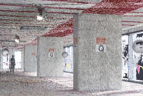
General contractors, architects, engineers, and facility managers often request 3D laser scanning services to obtain a point cloud of their building or site to ensure proper planning of their construction, renovation, or facility management project. A point cloud dataset offers precise measurements and spatial information in a digital format to create detailed design plans and improve construction workflows.
To use a point cloud, you typically need to import it into specialized software like AutoCAD, Revit, or other CAD or BIM software. Here you can visualize, analyze, and manipulate the 3D data, and generate 2D CAD drawings or 3D BIM models depending on your specific needs.
What is a Point Cloud?
A point cloud is the digital dataset captured with a 3D laser scanner. A laser scanner is equipped with LiDAR (Light Detection and Ranging) technology, which scans an object or environment by bouncing laser beams off surfaces to record a 3D digital representation of the space. Each point, containing X, Y, and Z coordinates along with additional data such as color, intensity, or classification, is plotted within a three-dimensional coordinate system.
What Can You Do with a Point Cloud?
A point cloud captures 3D data of a building’s exterior and interior, including structural elements, architectural details, utilities, dimensions, surface features, and surrounding terrain. It provides an accurate digital representation, helping with design, renovation, and maintenance planning by offering precise measurements and detailed visual data. Using a 3D laser scan point cloud depends on your goals and the software you have available.
Point Clouds for Construction and Architecture
Visualization:
Point clouds enhance visualization by delivering digital 3D representations of a building’s architectural, structural, and MEP features. Clients can import the point cloud into software like AutoCAD, Revit, CloudCompare, or Recap to view and analyze the data. This allows for precise modeling, design, and planning, improving decision-making and communication throughout the lifecycle of a project.
3D BIM Modeling:
A 3D BIM model is created by importing the point cloud data into specialized BIM software like Revit or AutoCAD, then manually tracing and interpreting the point cloud data to create intelligent 3D building elements like walls, floors, and ceilings, essentially "modeling" the structure based on the laser scan 3D data points. This process, often referred to as scan-to-BIM, ensures an accurate representation of the existing building conditions, and is useful for construction, renovation, and prefabrication projects.
Convert to a Mesh or Surface Model:
You can convert the point cloud to a 3D mesh with software like MeshLab, Geomagic, or Blender. Clients can perform a wide range of operations on a 3D mesh including: cleaning and repairing damaged meshes, editing geometry, smoothing surfaces, adding textures, inspecting details, converting file formats to STL or OBJ, preparing models for 3D printing, and even creating complex 3D animations.
Create 2D CAD Drawings:
To create sections, contours, or floor plans from a point cloud, clients can import the point cloud data into a CAD software like AutoCAD, then use tools like "section planes" to slice through the point cloud at specific angles, extracting the 2D geometry from the sliced view. Clients can trace or automatically generate lines based on the visible point cloud data to create a custom DWG or DXF 2D CAD drawing.
Measurement & Analysis:
Point clouds enable measurement and analysis by extracting precise dimensions and detecting changes in structures. They help analyze conditions, perform volumetric analysis, and study deformations. This data is crucial for monitoring structural integrity, ensuring accurate measurements, and supporting tasks like renovation, quality control, and planning for future developments.
Track Construction Progress:
Regular progressive construction laser scans can help track site evolution, monitor milestones, manage timelines, and ensure work stays on schedule. Point clouds record as-built site details, including utilities, concrete reinforcements, and MEP installations. Scans can be scheduled bi-weekly, monthly, or as needed.
Documenting Structures Before Demolition:
Point cloud data provides an accurate 3D record of a building before demolition, capturing its structure, materials, and utilities in a digital format. It allows engineers to analyze the existing conditions, identify hazardous materials, and plan safe demolition strategies. Additionally, the point cloud can be used for as-built documentation, ensuring critical features are recorded for future reference, redevelopment, or reconstruction.
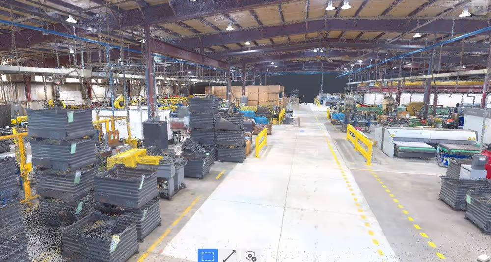
Point Clouds for Manufacturing and Engineering
As-Built Site Documentation & Digital Twin:
3D laser scanning captures the as-built condition of a facility in high detail, including exact layout of equipment, piping, and structures. A 3D BIM model or 3D digital twin can be created from the point cloud to foster collaboration on operations, engineering, and facility management.
Predictive Maintenance:
Facility managers can use point cloud data to anticipate equipment failures before they happen, reducing downtime and maintenance costs. Instead of following a fixed maintenance schedule, predictive maintenance relies on real-time monitoring and data analysis to determine when equipment needs servicing.
Structural Integrity & Safety Inspection:
Comparing the point cloud with original CAD or BIM models helps detect shifts, cracks, or deformations in structures and equipment. This process also identifies potential safety hazards, such as misaligned pipes, supports, or machinery, ensuring that the facility remains secure and operational.
Space Utilization & Workflow Optimization:
Point cloud data allows for precise layout and measurement of distances between equipment and pathways. By analyzing these spatial relationships, facilities can optimize equipment placement to enhance efficiency and ensure compliance with safety regulations.
Clash Detection & Retrofit Planning:
Simulating new equipment installations within the point cloud model helps to seamlessly integrate with existing structures. This proactive approach allows for the detection of conflicts before renovation begins, reducing the risk of rework and minimizing project costs. This is especially useful for equipment with no existing blueprints.
Quality Control & Inspection:
Point cloud data captures highly accurate 3D scans of components, allowing precise comparison with CAD models to check tolerances. It also can detect wear, deformation, or misalignment in machinery by analyzing deviations from the original design. This ensures parts meet specifications, reducing defects and improving reliability. Using point cloud-based inspection enhances accuracy, speeds up quality assessments, and helps identify potential failures before they impact production or safety.
Energy & Environmental Analysis:
Point clouds not only have spatial coordinates (X, Y, Z) but also a corresponding temperature value which can reveal heat leaks, ventilation issues, or insulation gaps that affect energy efficiency. By utilizing intensity values, facilities can optimize lighting and HVAC systems to improve overall energy performance and sustainability.
Compliance & Regulatory Audits:
Ensuring that fire exits, safety zones, and accessibility features comply with regulations is crucial for facility safety and legal adherence. Point cloud documentation serves as an essential record for insurance and regulatory audits, helping facilities maintain compliance and mitigate risks.
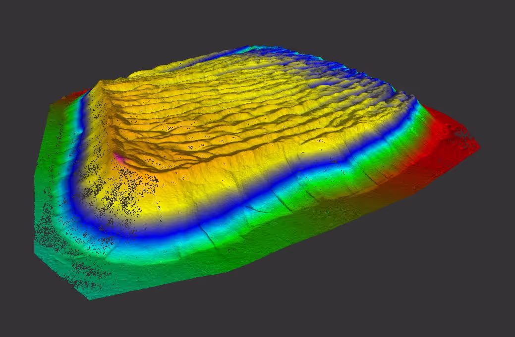
Point Clouds for Land Surveying & Mapping
Topographic Mapping:
3D laser scanning captures terrain elevations in a point cloud, accurately representing hills, valleys, and land contours. Clients can convert this data into detailed 2D topographic maps, commonly used in surveying, construction, and planning.
Infrastructure Monitoring:
Point clouds are ideal for infrastructure monitoring, allowing the tracking of changes in structures over time through repeated scans. This technology helps identify shifts, wear, or degradation in roads, bridges, and other infrastructure. By comparing scans, engineers can monitor conditions, predict maintenance needs, and ensure long-term safety and stability.
Point Clouds for Other Applications
Forensic Analysis:
3D laser scanning can be used to reconstruct complex accident sites and incident scenes in 3D with millimeter accuracy. The point cloud generated by laser scanning provides irrefutable demonstrative evidence that can be used at trial or mediation.
Cultural Heritage Preservation:
3D laser scanning delivers point cloud data of historical sites, documenting intricate architectural details for preservation and restoration. It creates accurate digital records of monuments, buildings, and artifacts, helping historians, archaeologists, and conservationists analyze structures without physical contact. These scans assist in restoration planning, detecting deterioration, and recreating damaged or lost elements. Additionally, point clouds allow for virtual tourism and research, ensuring cultural heritage remains accessible for future generations.
Virtual Site Walkthrough:
A point cloud can be used to create a virtual walkthrough by capturing a detailed 3D representation of a space. Point cloud data allows users to explore environments in an immersive, interactive way. Whether it's for real estate, architecture, or historical preservation, point clouds provide accurate measurements and visual details, enabling users to "walk through" spaces remotely. This enhances planning, design, and decision-making while offering a realistic experience without physical presence.
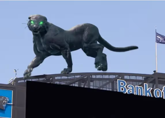
Virtual Reality, Mixed Reality and Augmented Reality:
A point cloud can be used to create immersive, interactive experiences by providing detailed 3D representations of real-world environments. In Virtual Reality (VR), point clouds allow users to explore fully interactive digital environments, perfect for training and simulation. In Mixed Reality (MR), point clouds integrate real-world and virtual elements, aiding in architectural design and construction planning. Point clouds can also be used to develop MR experiences during sporting events, including football games and even the Super Bowl. For Augmented Reality (AR), point clouds overlay detailed 3D models onto real-world views, enhancing site assessments and visualizations. In all three technologies, point clouds provide accurate spatial data, ensuring realistic experiences, making them essential in architecture, design, construction, and entertainment.
Video Game Development:
3D laser scanning captures detailed, dimensionally accurate 3D representations of real-world environments, ideal for video game development. This technology allows environments to be quickly documented and rendered, delivering photorealistic, high-detail point clouds that enhance game visuals.
Projection Mapping:
Point cloud data can be used to design 3D multimedia shows using the latest 3D projection mapping or video mapping techniques. 3D laser scanning enhances projection mapping by providing accurate, detailed 3D models of surfaces and environments. The point cloud data captures precise geometry, which is then used to map projections onto physical objects or buildings. This ensures that projections align perfectly with the surfaces, creating immersive, visually stunning effects. Ideal for events, art installations, or architectural projections, 3D laser scanning helps to create highly realistic, dynamic visuals that adapt to the unique contours and features of any surface.
Why Choose GPRS 3D Laser Scanning?
GPRS 3D laser scanning services capture as-built site conditions in a point cloud with provide unparalleled speed and accuracy. This level of detail helps avoid errors during construction, renovation, or restoration projects.
GPRS’ elite team of Project Managers efficiently 3D laser scans the exterior and interior of each site with professional-grade Leica laser scanners, capturing the exact layout, dimensions, and locations of your specific project requirements, such as architectural, structural, and MEP features, walls, windows, doors, stairs, roof, railings, exposed columns, beams, equipment, piping, ducts, and more.
Our Mapping & Modeling Team registers and processes the point cloud, removing noise and setting the coordinate system to provide the most precise measurements. Point cloud data is then compiled into custom 2D CAD drawings and 3D BIM models and delivered via SiteMap®. SiteMap® is GPRS’ free cloud-based software that delivers point cloud data, 2D CAD drawings and 3D BIM models, all in one platform.
What can we help you visualize?
Frequently Asked Questions
How much time does it take to create a point cloud?
It depends on the project scope. Most projects can be laser scanned in a couple of hours, or larger sites in a few days. After the scan is complete, the data must be registered and can be uploaded to the client. This process can take 2-3 days. 2D CAD sheets and 3D BIM models can be created from the point cloud data. This will take additional time from experienced CAD designers. To receive a project estimate, click here.
Can a point cloud be created in color?
Data can be captured in intensity (RGB), greyscale (black and white) and full color. Colorized point clouds combines the benefits of a photo (or photogrammetry) with the precision of laser scanning. To complete a full color laser scan, the building or site must have good lighting. Read about the benefits of scanning in color, click here.