Planning a renovation project for a historical building presents unique challenges that demand meticulous planning, technical expertise, and a deep understanding of the structure’s original design and materials.
Each architectural style is shaped by the technologies, materials, and cultural influences of its time, with distinctive elements such as decorative moldings, hand-carved details, vaulted ceilings, and innovative structural techniques that highlight exceptional craftsmanship and design.
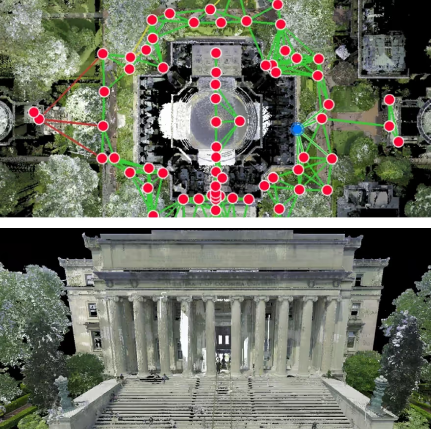
Accurately documenting existing conditions is critical to preserving architectural integrity while ensuring modern upgrades meet safety and code requirements. 3D laser scanning is an essential tool in this process, delivering precise spatial data of complex details, structural conditions, and intricate ornamental features.

What are the Challenges in 3D Laser Scanning a Historic Building?
Complex Architecture
Historical buildings often feature elaborate architectural details and decorative elements such as ornate moldings, domes, columns, arches, elaborate ceilings, and more that add significant cultural and historical value. 3D laser scanning can be challenging due to the complexity and size of these features.
Capturing fine architectural details requires the use of high-resolution scanning equipment and advanced scanning techniques to ensure the highest level of accuracy. 3D laser scanners can be configured with a higher point cloud density, which allows them to capture intricate features, textures, and fine details with exceptional precision. To cover every aspect of a feature, scanning is often completed from multiple angles, ensuring that no detail is missed. For tight spaces or hard-to-reach locations, handheld or portable scanners offer flexibility and better access.
For larger or more expansive structures, long-range 3D laser scanning captures data from a greater distance, effectively covering large areas such as ceilings, façades, and architectural elements. This combination captures data from both short and long distances, ensuring that all architectural details, no matter their size or complexity, are accurately documented and preserved.

Structural Issues
Historic buildings can face various structural issues, which can lead to uneven floors, leaning or bowing walls, and even collapse.
- Settling foundations
- Bowed walls
- Damaged masonry
- Weak beams
- Subsidence
- Damaged roofs
- Inadequate supports
- Water damage
They can also contain delicate materials, such as aging wood, deteriorating stone, or fragile plasterwork, that can be easily damaged by excessive movement or handling. These locations might not have the necessary structural integrity to support heavier 3D laser scanners, making their use in these environments potentially hazardous.
Using 3D laser scanners with long-range capabilities allows the technician to scan compromised areas from a safe distance. This can capture data from a larger area, avoiding the need to enter unsafe zones while still ensuring comprehensive data collection. Also, 3D laser scanners can be carefully positioned to minimize contact with fragile surfaces, while still capturing comprehensive structural and architectural details. Additionally, uneven or unstable structures may introduce alignment issues, requiring advanced techniques to ensure accurate data collection.

Accessibility Challenges
Many historic buildings have tight spaces, complex layouts, and restricted access to key areas, making it difficult to position scanning equipment. Historic buildings often contain narrow corridors, steep staircases, vaulted ceilings, and areas that may be concealed or hard to reach, such as attics, basements, or hidden passageways. These areas may be particularly problematic for traditional 3D laser scanning setups, as they can be too small or inaccessible for standard equipment. The irregular geometry of historic buildings further complicates scanning, as their walls, floors, and ceilings may be uneven or inconsistent.
3D laser scanning equipment can navigate tight spaces and irregular geometries, and can capture comprehensive data in hard-to-reach areas. Handheld or portable 3D laser scanners are often used to reach tight spaces and navigate complex layouts. These systems allow for more flexibility, as they can be maneuvered around obstacles and in confined areas, capturing high-resolution data without the need for large, bulky equipment.

Fine Artwork & Artifacts
Fine artwork, artifacts, and decorative elements are valuable, irreplaceable, and often heavily insured, which creates a challenge during the 3D laser scanning process. 3D laser scanning addresses this issue by providing a non-invasive way to capture precise measurements without physically touching delicate artwork. The scanner documents intricate details from a safe distance, preventing any disturbance or damage to fragile artwork, artifacts, and decorative elements.

Poor Lighting
Poor lighting can reduce the accuracy of 3D laser scans, especially in dark areas like historic buildings or basements. Without enough light, the laser may not reflect properly, causing shadowing or incomplete point clouds, which can cause gaps or distortion in the final 3D model.
To overcome poor lighting, experts use external lighting or scanners designed for low-light conditions with sensitive sensors. The scanning team adjusts equipment positions and takes multiple scans from different angles to cover shadowed areas. Post-processing software is then used to clean and correct the data, ensuring accurate point clouds.

Time Constraints
Historical buildings are often open to the public or located in high-traffic areas, which can disrupt the 3D scanning process, making it difficult to capture accurate data without interfering with visitors or ongoing work. The presence of crowds, noise, and the movement of people makes it difficult to capture accurate data without interference.
To address this, scanning is typically done after hours or in carefully planned phases, minimizing disruptions and ensuring that the scanning process does not interfere with public access or restoration efforts. Portable scanning equipment may also be used to minimize setup time and reduce the impact on the site, enabling efficient and precise data collection with minimal disruption. For example, the Leica RTC360 is a high-precision 3D laser scanner weighing 12 pounds and capturing 2 million data points per second for the rapid and efficient scanning of complex environments.

Regulatory and Legal Issues
3D laser scanning protected heritage sites may involve complex regulatory requirements and permissions, which can delay the scanning process and add extra layers of coordination and compliance.
To overcome this, experts work closely with local authorities and conservation bodies to ensure all necessary approvals are obtained and regulations are followed, ensuring a smooth and legally compliant scanning process.

What Are Common Renovation Projects for Historical Buildings?
Renovating a historical building requires careful planning to preserve its cultural and architectural value while updating it for modern use.
Common renovation projects for historical buildings include:
- Structural Reinforcement: Strengthening the foundation, walls, and roof to ensure the building’s stability, especially if it has suffered from wear, water damage, or natural disasters.
- Restoration of Decorative Features: Repairing or replicating intricate architectural details like carvings, moldings, or stained glass to restore the building’s original beauty.
- Modernizing Utilities: Updating plumbing, electrical, and HVAC (heating, ventilation, and air conditioning) systems to meet modern safety standards.
- Energy Efficiency Improvements: Installing energy-efficient windows, insulation, and heating/cooling systems to reduce energy consumption without compromising the building’s historic appearance.
- Preserving and Repairing Façades: Cleaning, restoring, and repairing the building’s exterior, including masonry, woodwork, or metal features, to preserve its original look and prevent further deterioration.
- Interior Renovation: Redesigning interior spaces for modern use while retaining key historical elements like original floors, ceilings, and walls. This may include adding contemporary lighting, or reconfiguring spaces for new functions.
- Accessibility Upgrades: Installing ramps, elevators, or other accessibility features to meet modern standards, making the building more accessible.
- Fire Protection and Safety Compliance: Installing modern fire suppression systems, emergency exits, and safety features to bring the building up to code.
- Adaptive Reuse: Repurposing the building for a new function, such as converting a former office building into mixed-use housing.

Preserving History with Precision: How GPRS 3D Laser Scanning Supports Historic Building Restoration
GPRS is a leading provider of 3D laser scanning services, helping clients to complete architecture, engineering and construction projects with accurate as built documentation.
GPRS delivers critical data that helps preserve historical buildings, guides accurate restoration, and supports efficient, cost-effective renovation processes while maintaining the building's historical integrity.
- Precise Documentation: 3D laser scanning captures the exact dimensions and geometry of a building, creating a digital, high-resolution point cloud. This delivers a precise record of the building’s current state, including intricate architectural details such as moldings, carvings, and decorative elements, ensuring that no aspect is overlooked during renovation.
- Accurate Measurements for Restoration: The data collected by the scanner allows for precise measurements of the structure, helping architects and engineers to design and implement restoration plans with exact specifications. This minimizes errors and ensures that restoration work aligns with the original design.
- Preservation of Architectural Features: 3D scanning allows for the detailed capture of delicate and intricate architectural features that need to be preserved, such as ornamental moldings, stained glass, or carvings. The scan data can be used to replicate these features if necessary, ensuring they are accurately restored or replaced without damaging the original elements.
- Virtual Design and Construction: With the data from 3D laser scanning, a detailed digital model of the building can be created. This model can be used for virtual design and construction, allowing planners to test different renovation approaches and assess the impact on the building before any physical work is done. This helps avoid mistakes and minimizes disruption to the structure.
- Structural Analysis: 3D scans can identify areas of the building that may require structural reinforcement, such as weakened walls or foundations. The data helps engineers to analyze the structural integrity of the building and plan for necessary interventions without compromising the building’s historic character.
- Integrating Modern Systems: 3D laser scanning facilitates the integration of modern systems (HVAC, plumbing, electrical, etc.) into historical buildings by providing accurate data on available space, dimensions, and the positioning of existing equipment and structures. This ensures that renovations are both functional and respectful of the building’s original design.
- Reducing Time and Cost: Traditional measurement methods can be time-consuming and prone to human error. 3D laser scanning speeds up the documentation and planning phase, reducing labor costs and time while ensuring that renovation work is based on precise data.
- Accessing Hard-to-Reach Areas: 3D laser scanning can access and accurately capture details in hard-to-reach areas, such as high ceilings, narrow passageways, or hidden corners, where manual measurements would be challenging or unsafe.
Why Choose GPRS 3D Laser Scanning? The GPRS Difference.
Every GPRS Project Manager completes an extensive training program to ensure their competence in laser scanning equipment and field knowledge to provide the best possible results for every project.
We use industry-leading Leica survey-grade laser scanners to capture comprehensive point cloud data. The data captured is complete, clean, accurate, and well filtered with low range noise. Point clouds deliver powerful and dynamic information for a project. By representing spatial data as a collection of x, y, and z coordinates, point clouds deliver large datasets that can be mined for information.
The GPRS Mapping & Modeling Team transforms point clouds into 2D CAD drawings, 3D BIM models, 3D meshes, TruViews, and virtual tours of the highest quality standards.
Partnering with GPRS delivers you accurate point cloud data, drawings, and models to expedite project planning and reduce change orders, delays, and costs.