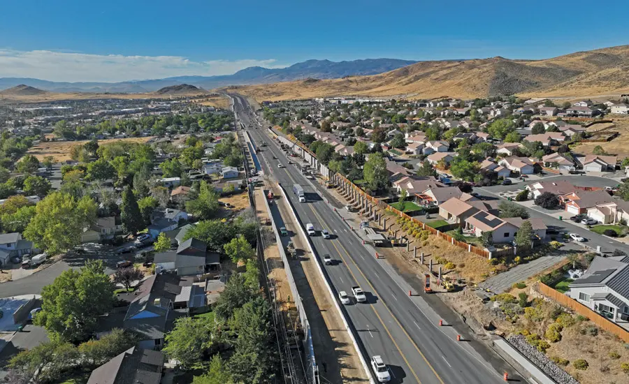
A $66-million road project near Reno, Nevada hit a major speedbump when it was discovered that a high-pressure water line ran right through the project area.
Watsonville, California-based Granite Construction is the general contractor on the first phase of the six-phase Pyramid Highway Project, which is rebuilding and widening about 2.5 miles of the arterial road that serves 50,000 vehicles daily.
Expected to be completed this summer, this project will see much of the road expand from four to six lanes, along with the addition of bike lanes, sidewalks curbs, gutters, a 10-ft shared-use path on one side of the road, smart traffic signals, sound walls, enhanced lighting, landscaping, and improved drainage infrastructure.
“These upgrades are designed to improve traffic flow, safety and accessibility for all users,” Nanette Maxwell, senior project manager for NDOT, the lead agency on the project, told Engineering News-Record. “This project will not only reduce traffic congestion and travel times, but it will also generate significant crash-cost savings for vehicles, bicyclists and pedestrians” because the improvements are expected to reduce accidents.
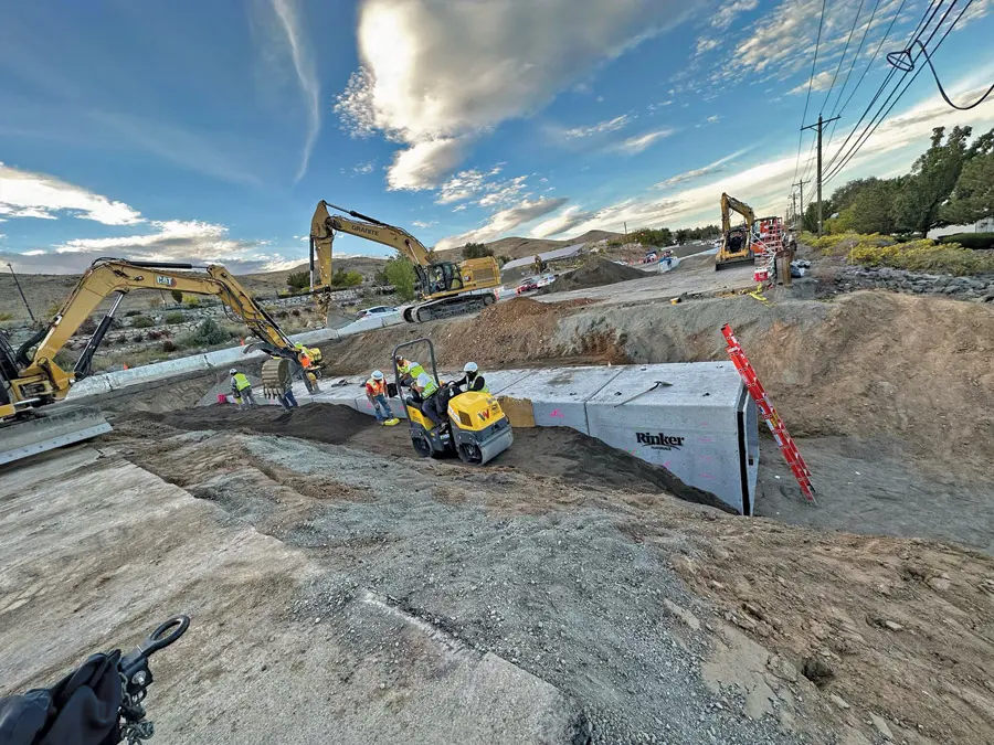
According to ENR, the local water utility notified the construction team about the previously unidentified water line running through the project area. The line serves the nearby community of Spanish Springs, and the water utility told the construction team that it needed to be at least 2 ft below ground.
A subsequent review of subsurface utility exploration data revealed a small section of the pipe would have less than 2 ft of cover.
Revealing too much of the high-pressure line risked compromising its integrity, and shutting off the water was not feasible. To mitigate the risk, crews advanced in 50-foot sections, excavating and clearing surface material down to the subgrade. The exposed area was then graded and compacted. A temporary gravel layer was placed over the pipe for protection, which will later be replaced with an aggregate base during final roadway construction.
“Meetings were held between NDOT, Granite and the local water authority to develop a work plan allowing the contractor to continue working,” Aaron Lobato, roadway design project coordinator at NDOT, told ENR.
Amanda Callegari, commission engineering manager, told the publication that the collaborative elements of the project – including the real-time multiagency cooperation necessary to overcome the water line problem – show how important Pyramid Highway is to Reno’s present and future. The highway – designated State Route 445 – is an important commuter route for the area’s growing population, with more than 90% of the 40,000 people who live within two miles of the project working outside the area.
“This project holds regional significance and will provide meaningful benefits to the growing community,” Callegari said. “To ensure its successful delivery, the [commission] and NDOT have joined forces to implement these vital improvements.”
How Accurate Utility Locating Protects Your Infrastructure Projects
Whether it’s a high-pressure water line, an electrical conduit, or a gas main, striking a buried utility while excavating can have costly consequences.
Subsurface damage endangers the lives of your workers and residents of the surrounding community. And the downtime and cost of repairing the damage can decimate your schedule and budget.
Calling your local 811 center should be your first step whenever you’re planning an excavation. Federal law requires you contact 811 to receive the approximate location of all registered utilities within your project area prior to breaking ground. Registered utilities can consist of both private and public lines, but it’s important to remember that not all utilities are registered with 811.
GPRS’ professional utility locating services compliment your 811 locate by providing you with accurate and complete data about the buried infrastructure on your job site. Utilizing ground penetrating radar (GPR), electromagnetic (EM) locating, and other non-destructive subsurface investigation technologies, we identify where you can and can’t safely dig.
All this data is at your fingertips 24/7 thanks to SiteMap® (patent pending), GPRS’ interactive utility mapping software application that provides accurate existing conditions documentation to protect your assets and people.
Securely accessible from any computer, tablet or smartphone, SiteMap enables seamless communication between you and your project team. You’ll be able to plan, design, manage, dig, and ultimately build better.
From skyscrapers to sewer lines, GPRS Intelligently Visualizes The Built World® to keep your projects on time, on budget, and safe.
What can we help you visualize?
Frequently Asked Questions
What do I get when I hire GPRS to conduct a utility locate?
Our Project Managers flag and paint our findings directly on the surface. This method of communication is the most accurate form of marking when excavation is expected to commence within a few days of service.
GPRS also uses a global positioning system (GPS) to collect data points of findings. We use this data to generate a plan, KMZ file, satellite overlay, or CAD file to permanently preserve results for future use. GPRS does not provide land surveying services. If you need land surveying services, please contact a professional land surveyor.
Please contact us to discuss the pricing and marking options your project may require.
What are the Benefits of Underground Utility Mapping?
Having an updated and accurate map of your subsurface infrastructure reduces accidents, budget overruns, change orders, and project downtime caused by dangerous and costly subsurface damage.
How does SiteMap® assist with Utility Mapping?
SiteMap®, powered by GPRS, is the industry-leading infrastructure management program. It is a single source of truth, housing the 99.8%+ accurate utility locating, concrete scanning, video pipe inspection, leak detection, and 3D laser scanning data our Project Managers collect on your job site. And the best part is you get a complimentary SiteMap Personal Subscription when GPRS performs a utility locate for you.
Does SiteMap Work with my Existing GIS Platform?
SiteMap allows for exporting of data to SHP, GeoJSON, GeoPackage, and DXF directly from any user’s account that either owns or has a job shared to their account. All these file formats can be imported and utilized by other GIS packages if manually imported by the user.