

.svg)
GPRS 2D CAD Drawing Services
Before project planning begins, many clients desire a set of construction drawings, drawn to scale, that document a building’s existing architecture, mechanical systems, and layout. 2D CAD drawings are an important tool for architects, engineers, and contractors, as they provide accurate and detailed technical information about a building or project site.
GPRS delivers accurate and customized 2D CAD drawings for your architecture, construction, and engineering projects. First, GPRS 3D laser scans your site using LiDAR technology to capture exact building dimensions, locations, and layout with 2-4mm accuracy. That data is initially captured in the form of a point cloud. The GPRS Mapping and Modeling Team imports point clouds into CAD software to create customized 2D CAD drawings with great precision. They can also create a 3D model in BIM software and take a “slice” of the 3D model to create a 2D CAD drawing.
Site plans, floor plans, elevations, sections, details, isometric drawings, reflected ceiling plans, and more can be created and are used for construction planning and building modifications. Drawings can be annotated with text, dimensions, leaders, and tables for the client’s needs. 2D engineering drawings provide an easy reference of the tolerances that need to be met on critical dimensions.

What are 2D CAD Drawings?
CAD is defined as computer-aided design or computer-aided drafting. Prior to CAD software, CAD drawings would have been created by experienced CAD drafters and required tools such as stencils and T-squares. CAD software has replaced these manual, hand-drafted drawings with a digital method, significantly increasing the efficiency and accuracy of the drafting process. 2D CAD drawings are characterized by their two-dimensional lines, polylines, and arcs, as well as text and annotations.
2D CAD drawings can also be referred to as construction drawings, plan views, architectural drawings, as-built drawings, construction plans, 2D drawings, CAD drawings, blueprints, technical drawings, structural drawings, and finishing drawings. 2D drawings can provide a clear, detailed representation of the project layout, dimensions, and specifications. This can help architects, engineers, and contractors understand the design requirements.

GPRS 2D CAD Drawing Services
Before project planning begins, many clients desire a set of construction drawings, drawn to scale, that document a building’s existing architecture, mechanical systems, and layout. 2D CAD drawings are an important tool for architects, engineers, and contractors, as they provide accurate and detailed technical information about a building or project site.
GPRS delivers accurate and customized 2D CAD drawings for your architecture, construction, and engineering projects. First, GPRS 3D laser scans your site using LiDAR technology to capture exact building dimensions, locations, and layout with 2-4mm accuracy. That data is initially captured in the form of a point cloud. The GPRS Mapping and Modeling Team imports point clouds into CAD software to create customized 2D CAD drawings with great precision. They can also create a 3D model in BIM software and take a “slice” of the 3D model to create a 2D CAD drawing.
Site plans, floor plans, elevations, sections, details, isometric drawings, reflected ceiling plans, and more can be created and are used for construction planning and building modifications. Drawings can be annotated with text, dimensions, leaders, and tables for the client’s needs. 2D engineering drawings provide an easy reference of the tolerances that need to be met on critical dimensions.
What are 2D CAD Drawings?
CAD is defined as computer-aided design or computer-aided drafting. Prior to CAD software, CAD drawings would have been created by experienced CAD drafters and required tools such as stencils and T-squares. CAD software has replaced these manual, hand-drafted drawings with a digital method, significantly increasing the efficiency and accuracy of the drafting process. 2D CAD drawings are characterized by their two-dimensional lines, polylines, and arcs, as well as text and annotations.
2D CAD drawings can also be referred to as construction drawings, plan views, architectural drawings, as-built drawings, construction plans, 2D drawings, CAD drawings, blueprints, technical drawings, structural drawings, and finishing drawings. 2D drawings can provide a clear, detailed representation of the project layout, dimensions, and specifications. This can help architects, engineers, and contractors understand the design requirements.
What Types of 2D CAD Drawings Does GPRS Create?
Site Plans
A site plan, sometimes referred to as a plot plan, is the graphic representation of all existing site conditions. The site plan maps the entire layout of the project site, including the location of buildings, paving, utilities, and terrain features in a single depiction.
Floor Plans
Floor plans show the layout and spatial relationship between rooms, spaces, and elements such as walls, doors, windows, and furniture. Architects, engineers, and builders use floor plans for design and retrofit projects.
Interior Elevations
Interior elevation drawings are 2D drawings that show the interior of a building from various angles. They are used to show the size and shape of a building, as well as the placement of windows, doors, and other features.
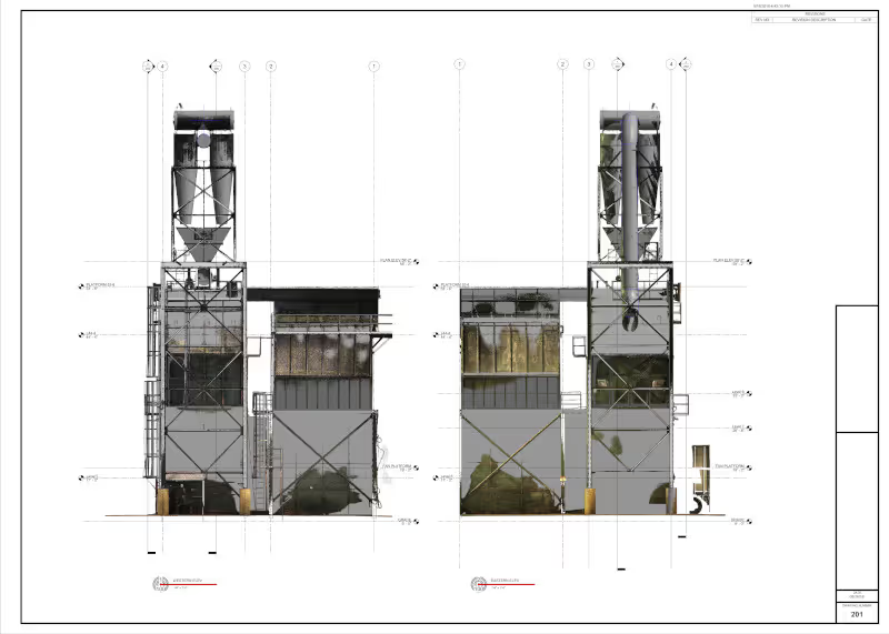
Exterior Elevations
Exterior elevation drawings are used to show how a building looks from the outside. They precisely document the outline of a building, and the placement of windows and doors. Design professionals would request as-built exterior elevations to understand how the different levels of a building stack, and how the windows and doors align and are placed.
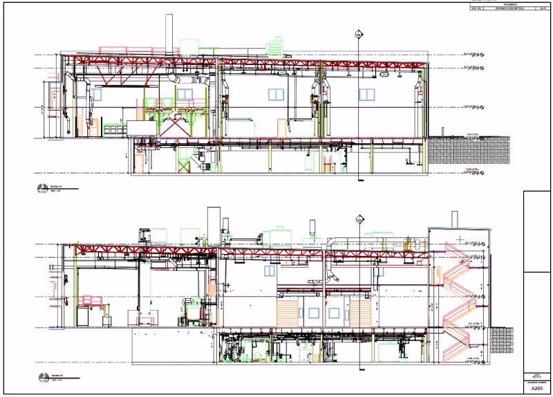
Sections or Cross Sections
Sections are 2D drawings that show the cutaway view of a building, structure, or object, disclosing details of the internal structure.
Details
Details are 2D drawings that show a specific element of a building, structure, or object enlarged in more detail. The element is scaled for dimensioning and clarification purposes.
Isometric Drawings
An isometric drawing is a representation of a 3D object drawn on a flat plane that mainly contains 2D coordinates – the x and y axes. Although it uses a 2D coordinate system, it gives the illusion that a 3D system is being used. Isometric drawings are made by tilting the viewing angle to 30 degrees for all sides in the 2D plane.
Mechanical and Electrical Drawings
These drawings provide detailed information about the plumbing, HVAC, electrical, and other mechanical systems (MEP) used in a building.
Reflected Ceiling Plan
A reflected ceiling plan shows the outline of the ceilings, the varied ceiling levels, vent locations, and the different types of lighting fixtures.


.avif)


What are the Benefits of CAD Drawings in Construction?
Documentation
CAD drawings provide valuable as-built documentation during construction. They can be used for record-keeping, construction and renovation planning, and maintenance.
Visualization
CAD drawings allow architects, engineers, and contractors to visualize the project before construction begins. This helps to make informed decisions about the design.
Accuracy
CAD drawings can be mined for accurate measurements, reducing errors in construction. This precision is essential for ensuring that different components fit together correctly.
Efficiency
CAD drawings streamline the design process, allowing for faster iterations and modifications. This efficiency can lead to cost savings and shorter project timelines.
Communication
CAD drawings serve as a common language among architects, engineers, contractors, and other stakeholders. They help in communicating design intent and specifications clearly.
Coordination
CAD drawings enable different teams and trades to coordinate their work effectively. For example, architectural drawings can be integrated with structural and MEP (mechanical, electrical, plumbing) drawings to ensure compatibility.

Why GPRS? The GPRS Difference.
With GPRS, clients can rest assured that our elite Project Managers use state-of-the-art 3D laser scanning technology to document accurate existing conditions information. Every GPRS Project Manager completes an extensive training program to ensure their competence in laser scanning equipment and field knowledge to provide the best possible results for every project.
We use industry-leading Leica survey-grade laser scanners to capture comprehensive point cloud data. In most cases, a 3D laser scan captures 2 million data points per second. The data produced is complete, clean, accurate, and well-filtered with low range noise. Point clouds provide powerful and dynamic information for a project. By representing spatial data as a collection of x, y, and z coordinates, point clouds deliver large datasets that can be mined for information.
Our Mapping & Modeling Team transforms point clouds into 2D CAD drawings, 3D BIM models, 3D meshes, TruViews, and virtual tours of the highest quality standards.
Partnering with GPRS means you receive accurate as-built data, 2D drawings, and 3D models to expedite project planning and reduce change orders, delays, and costs.
GPRS, an industry leading 3D laser scanning company, delivers outstanding service with cutting-edge technology – to keep your projects on time, on budget, and reduce risk.
What can we help you visualize?
///INDUSTRIES We serve

Power Transmission & Distribution

Telecom

Renewable Energy

Oil & Gas

Power Generation

Facilities

One Call

Environmental Due Diligence

Civil, Road & Bridge

Design Builds & Remodels

Education

Retail & Restaurant Construction

Water & Sewer
Electric Vehicle Charging

Engineering & Surveying
Other
Samples of 2D CAD Drawings


Articles

Scan-to-BIM technology helps you take any project from inception to completion with accurate and easy to understand data integration to ensure smooth communication and avoid cost overruns and delays. What project can GPRS help you visualize?
Laser scanning is an unmatched facility documentation and management tool with benefits that span the life of any facility. Our Project Managers, model designers, and CAD designers work together to help you Visualize The Built World® to help you reduce downtime and costs so that your projects come in on time and on budget.
USIBD is an organization dedicated to creating standards for building documentation. GPRS 3D Laser Scanning strongly believes in the importance of creating specifications and guidelines for the US construction industry. These established criteria drive quality excellence, improve efficiencies, establish expectations and build credibility. For these reasons, GPRS is proud to be a member of US Institute of Building Documentation.
GPRS 3D Laser Scanning is an unmatched facility documentation and management tool with benefits that span the life of any facility. Our Project Managers, model designers, and CAD designers work together to help you Intelligently Visualize The Built World™ to help you reduce downtime and costs so that your projects come in on time and on budget.