GPRS 3D Laser Scanning Process
GPRS is a leading provider of 3D laser scanning services, helping clients to successfully complete their most complex architecture, engineering, and construction projects with accurate as-built documentation and custom 2D CAD and 3D BIM deliverables. The 3D laser scanning process involves several key steps to ensure the accurate capture, processing, and delivery of high-quality 3D laser scan data. Project Managers need extensive knowledge and experience to understand the 3D laser scanning process and use it successfully. Those steps are detailed below.

Plan
Our dedicated and experienced team collaborates closely with each client to thoroughly understand their unique project scope. We take time to dive deep into their needs and goals, ensuring tailored, innovative solutions that not only meet, but exceed expectations.
Proper planning before 3D laser scanning is essential to outline the timeline, understand the site conditions, select the right equipment, and specify technical requirements such as software, deliverables, and level of detail. Our commitment to excellence and attention to detail enable us to deliver optimal 3D laser scanning solutions that drive success for every project.

Scan
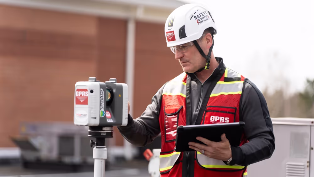
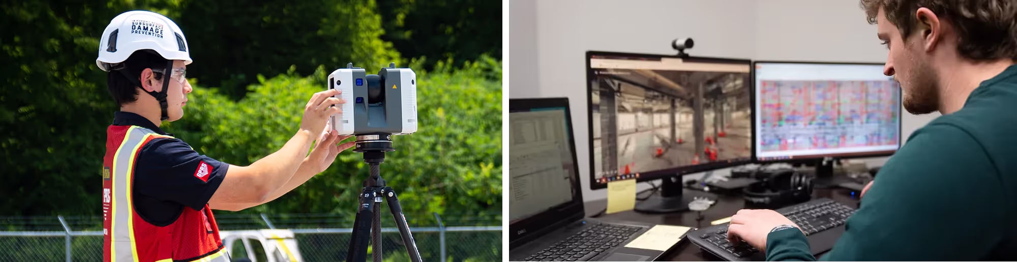
Our elite Project Managers utilize a range of Leica laser scanners to capture highly detailed and accurate representations of the project site in 3D, often referred to as a point cloud. The point cloud documents every visible detail of the site, including the exact size, shape, and spatial relationship of every architectural, structural, and MEP detail, making it invaluable for as-built documentation, construction planning, or design.
The Project Manager will choose the appropriate laser scanner (terrestrial or Matterport scanner) based on the size, detail, and accuracy needed for the project. A laser scanner captures millions of X, Y, Z coordinates, delivering clients 2–4 mm accurate dimensions, and layout of the scanned environment.
The Project Manager will familiarize themselves with the scope and create a plan for complete data capture. This will ensure coverage of the scan area from all angles while working around obstructions and trades on site. This process includes determining the scanner set-up locations, planning the workflow, documenting obstacles and intricate MEP, and estimating the time needed on site.
Each member of GPRS’ nationwide team of 3D Laser Scanning Project Managers has completed the industry-leading Subsurface Investigation Methodology (SIM) certification process. This program defines protocols for 3D laser scanning that far exceed the industry norm. The SIM certification process consists of 80 hours of hands-on classroom training and 320 hours of mentorship in the field, plus another 40 hours of LiDAR training to ensure Project Managers’ competence in 3D laser scanning equipment and field knowledge.

Registration
The registration of a laser scan point cloud is a crucial process in 3D laser scanning because it ensures that the multiple laser scans captured on site are accurately aligned and merged into a single, cohesive dataset. The GPRS Mapping & Modeling Team processes the point cloud, removing any noise, duplicate points, or unnecessary objects, and aligns the scan data with the real-world coordinate system to deliver a clean and precise dataset for further processing. This unified dataset is used to generate accurate 3D models, 3D meshes, and 2D CAD drawings (e.g., floor plans, elevations, reflected ceiling plans, etc.).
Accurate registration ensures that all scans are correctly aligned, maintaining the true spatial relationships between objects in the real world, providing the foundation for accurate measurements, whether it's distances, angles, areas, or volumes. If scans are not properly registered, the resulting point cloud will have misalignments, errors, or distorted geometry, leading to inaccurate measurements or misrepresentations of the site.

Data Processing
Our team’s experience and attention to detail ensures that we gather and process comprehensive and precise information, enabling us to create highly reliable 2D CAD drawings, 3D BIM models, 3D mesh models, TruViews, 3D virtual tours and more for every project. Deliverables can be provided at any level of detail in a variety of software formats including Revit, AutoCAD, ReCap, Navisworks, Civil 3D, BIM 360, A360, JetStream Viewer, and more.
We take pride in creating all our point cloud, 2D, and 3D deliverables in house, ensuring a seamless and integrated approach to project development. GPRS can deliver custom data analysis and calculations, for example prefabrication of components, floor flatness and levelness analysis, deviation analysis, deformation analysis, new construction verification, volume calculations, wall plumb analysis, staircase dimensional analysis, tank calibration analysis, elevator shaft analysis, accident scene reconstruction, and so much more.
By delivering high-quality, accurate data, we help facilitate informed decision-making during every stage of construction, including design planning, preconstruction, and field execution. Our Mapping & Modeling Team helps clients transform their visions into reality while optimizing resources and enhancing collaboration throughout the entire project lifecycle.

Quality Assurance
The GPRS Mapping & Modeling Team employs a rigorous quality control process that thoroughly inspects every point cloud and deliverable, ensuring the highest standards of accuracy and reliability for our clients. The GPRS team prioritizes quality at every stage, allowing us to improve the overall effectiveness of our services and ensure long-lasting client relationships built on trust and dependability. We review the deliverables with the client and make any necessary adjustments.

Delivery
We take the extra steps during data transfer to ensure that the data is both usable and easily accessible. We work closely with each client to select the right format, optimize and compress the data, and use the most suitable method to transfer the data securely.
We help clients to learn the pros and cons of different data transfer options and identify the best ones to receive their project. There are specialized cloud-based platforms that are designed for managing and sharing large point cloud datasets and 3D BIM models that include tools for visualizing the data without needing specialized software.
GPRS quickly delivers data, drawings, maps, and models using a variety of file types customized to the clients' needs, such as cloud platforms, and our new infrastructure data platform, SiteMap® (patent pending). We can offer technical support to assist the client in working with the scan data, especially if it’s their first time handling point clouds or 3D models.
We are committed to Intelligently Visualizing The Built World®, and that means exceeding client expectations to deliver the highest quality point cloud data, 2D CAD drawings, and 3D BIM models, on time, and within budget. Our unwavering dedication to client satisfaction drives us to ensure that every project is completed to the highest standards, fostering lasting partnerships with every client for their architecture, engineering and construction project.
What can we help you visualize?
What is 3D Laser Scanning?
3D laser scanning utilizes LiDAR technology to precisely capture the three-dimensional data of a structure or site. LiDAR, which stands for Light Detection and Ranging, operates by emitting light as a pulsed laser to measure distances to a target. When these laser pulses bounce back to the scanner, the distances are recorded, mapping the spatial geometry of the area. This process collects millions of measurement points, each with x, y, and z coordinates, forming what is known as a point cloud.
The intricacy of these data points allows for exact measurements between any two points within the point cloud. This data can then be converted into 2D CAD drawings or 3D BIM models, which are invaluable for construction and engineering projects. To explore more about 3D laser scanning, click here.
What Scanners are Used for Data Collection?
Terrestrial laser scanners are used for data collection, as they can easily document vertical structures, such as buildings and facilities. These scanners sit on a tripod and can take 1-3 minutes to complete each scan, depending on the project requirements. Terrestrial laser scanners are known to produce the most accurate point clouds because they are stationary. Note that a laser scanner can only capture what is in its field of view. Scanners are positioned around a site and take individual scans from varying viewpoints to capture complete site data. The captured points record everything from surface detail and texture, to color, creating a direct representation of the scanned project site. Click here to read more about the equipment used for data collection.


.avif)


What are the Steps of the 3D Laser Scanning Process?
3D laser scanning captures as-built documentation of buildings and sites with 2-4mm precision in most cases. Project Managers need extensive knowledge and experience to understand the 3D laser scanning process and use it successfully. GPRS’ SIM-Certified Project Managers follow these steps when conducting 3D laser scans:
- Define Project Scope: The Project Manager meets with each client to understand their project scope and provide optimal solutions based on the project requirements.
- Conduct Site Walk: The Project Manager walks the project site to familiarize themselves with the scope and create a plan for complete data capture. The Project Manager will ensure coverage of the scan area from all angles and work around obstructions. This process includes determining the scanner set-up locations, planning the workflow, documenting obstacles and intricate MEP, and estimating the time needed on site.
- Capture Data: The Project Manager positions the scanner around the site, taking individual scans from varying viewpoints to capture complete site data.
- Registration: The individual scans are aligned and fitted together. GPRS’ in-house Mapping and Modeling Team registers and processes the point cloud, removing noise and setting the coordinate system to provide the most precise measurements.
- Quality Checks: A registration QA/QC check is performed to ensure all the scans fit together, so the point cloud and models have tight lines and accurate measurements.
- CAD/BIM Development: Point cloud, 2D CAD drawings, and 3D BIM models are created in-house, and QA/QC checked to ensure precision. Construction drawings and models can be provided at any level of detail in a variety of formats, including Revit, AutoCAD, ReCap, Navisworks, Civil 3D, BIM 360, A360, and JetStream Viewer.
- Transfer Data: Data is efficiently transferred to clients via SiteMap®, GPRS’ digital storage software and app, Sharefile, Cloud platforms, or mailed on a hard drive.
For More Information on 3D Laser Scan Technology
GPRS 3D Laser Scanning Services offer an accurate solution to obtaining on-site measurement data for construction, engineering, and design projects. Terrestrial laser scanners are known to produce the most accurate point clouds. Our Project Managers ensure successful data capture, registration, and CAD/BIM deliverable creation.
For questions on 3D laser scanning, terrestrial laser scanners, and the steps of the laser scanning process, contact GPRS today at 419-843-7226 or email Laser@gprsinc.com.
From office buildings and manufacturing facilities, to stadiums and schools and more, GPRS Intelligently Visualizes The Built World® to keep your projects on time, on budget, and safe.
Case Studies

.avif)


"[The Technician] did a good job of getting up to speed and working with little or no direction, which helped us concentrate on our other needs on site."
Steve H.
Project Manager
"The scan helped tremendously and has saved us quite a bit of time and trouble."
Gene A.
Mechanical Integrity Engineer
"Thanks for jumping into this assignment so quickly. What a great and productive trip. You guys work tirelessly, non-stop with all aspects of the set-up and execution. Your ability to master the technology is a game changer for us."
Don A.
Executive Vice President, Director of Architecture, Engineering & Technology
"We have been very pleased with the results of the scanning process. The product has been very useful. And has certainly helped in the development of the project. I would certainly use GPRS again on future projects."
John G.
President & Principal Architect
"Our disciplines have been utilizing the Point Cloud and TruView information and it has been of value. We have discovered a few clashes with our structural steel, which may not have ever been caught, so I feel the service has already paid for itself."
Joseph G.
P.E., Project Manager

Scan-to-BIM technology helps you take any project from inception to completion with accurate and easy to understand data integration to ensure smooth communication and avoid cost overruns and delays. What project can GPRS help you visualize?
Laser scanning is an unmatched facility documentation and management tool with benefits that span the life of any facility. Our Project Managers, model designers, and CAD designers work together to help you Intelligently Visualize The Built World™ to help you reduce downtime and costs so that your projects come in on time and on budget.
USIBD is an organization dedicated to creating standards for building documentation. GPRS 3D Laser Scanning strongly believes in the importance of creating specifications and guidelines for the US construction industry. These established criteria drive quality excellence, improve efficiencies, establish expectations and build credibility. For these reasons, GPRS is proud to be a member of US Institute of Building Documentation.
GPRS 3D Laser Scanning is an unmatched facility documentation and management tool with benefits that span the life of any facility. Our Project Managers, model designers, and CAD designers work together to help you Intelligently Visualize The Built World™ to help you reduce downtime and costs so that your projects come in on time and on budget.