

.svg)

Highlights
THE BOTTOM LINE
The level of detail provided to the client in both the 3D laser scan data and 3D BIM model exceeded expectations and helped the client to expedite fabrication drawings.
Industry
Oil & Gas
Service
3D Laser Scanning, Mapping & Modeling
Location
Cleveland, Ohio
GPRS Project Manager Insight
Deliverables
The client received Recap files for use in Autodesk MEP as well as 2D CAD drawings in .dwg format. These drawings identified bolt hole patterns, centerline locations, elevation of features, connection points, and pitch of inlets and outlet flanges.
PROJECT APPLICATION
A midstream energy company was preparing for the turn-key installation of multiple meter stations along a dual 42” pipeline running from Pennsylvania, through West Virginia and Ohio, up through Michigan.
ASK
Task
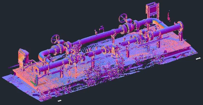
An electrical, mechanical, and fabrication construction services company requested 3D laser scanning and BIM modeling services to capture point cloud data and generate a 3D model of the inlet and outlet flange information for 27 natural gas separator units and 64 meter/regulation skids. A GPRS Project Manager captured detailed flange information, including bolt hole orientation, elevation information, and pitch of flanges with a 3D laser scanner. Then, using the point cloud data collected, the GPRS Mapping & Modeling Team generated a 3D model of each skid’s flange information. This information will be used by the client for prefabrication, with the goal of minimizing field changes during installation.
PROBLEM
These were the challenges for our client:
- The client had a limited window to capture detailed flange information while the skids were in a staging area.
- The skids were not sitting in their final resting place, it was imperative that the measurements were all relative to the skid and not survey coordinates.
- Prefabrication information needed to be collected quickly so the skids could be moved.
- The client needed to ensure that when all the flange connections between skids were connected that everything fit perfectly with little to no room for adjustment.
Solution
This 3D laser scanning solution for a midstream energy company involved using a LiDAR laser scanner to capture detailed 3D point cloud data of the natural gas separator units, meter/regulation skids, and surrounding infrastructure:
- GPRS worked closely with the client to coordinate site access and capture detailed flange information.
- The Project Manager was meticulous in the identification of each skid during data collection and relayed the information to the GPRS Mapping & Modeling team.
- All of the 3D laser scan data for each skid was captured separately; therefore, the coordinates for the input flange and output flange could be precisely determined within the scan data.
- Additionally, the client could integrate the point cloud data captured for each skid with their model for prefabrication.
Benefits
- GPRS’ experience with complex point cloud data aided in the speed, accuracy, and analysis of the information captured.
- The level of detail provided to the client in both the scanning and deliverables helped expedite the client’s processing and generation of fabrication drawings.
- During installation, when the skids were all connected together there was no need for field adjusting the prefabricated pipes and flanges, saving this client both time and money.
CASE STUDY GALLERY


.avif)


.avif)
