

.svg)
Agricultural
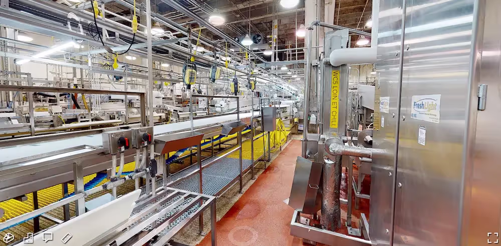
GPRS provides utility locating, concrete scanning, 3D laser scanning, video pipe inspection, and leak detection services for the Agricultural industry. The professionals at GPRS have extensive experience working with agricultural facilities, including grain handling, storage, feed, milling, and processing plants. We have provided services for grain facilities, ethanol facilities, production agriculture, grain processing operations, and suppliers to the food corn industry.
From the initial planning and design of a grain silo, to engineering grain intake and distribution towers, to construction of a grain loading dock, to replacing ducts and piping for a grain chute, to analyzing tank farm slab elevation contours, to mapping existing underground infrastructure – and everything in between – GPRS has the resources to create a solution for your business needs.
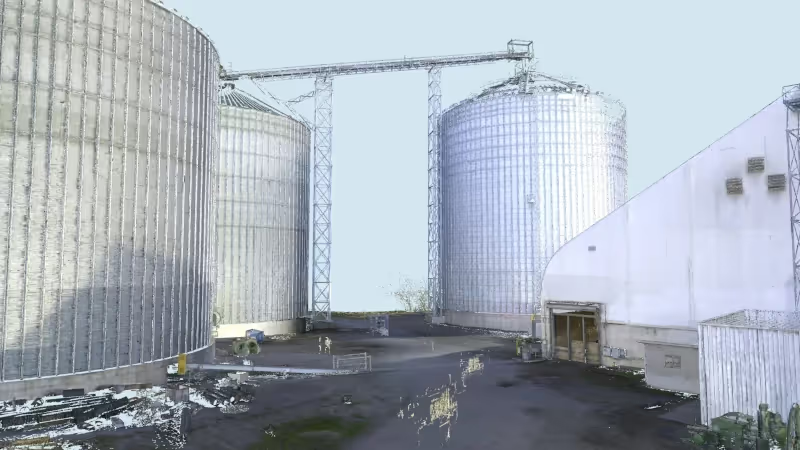
We have completed scanning projects ranging from small rooms to entire facilities. We have captured precise data of grain intake and distribution towers, tanks, silos, hoppers, conveyors, support cables, structural members, machinery, equipment, utilities, rail spurs, catwalks, cleaning houses, grain elevators, drive throughs, and so much more.

GPRS Delivers Complete Infrastructure Visualization
GPRS is the only company in the U.S. that can capture your entire site or facility, above and below-ground, to provide you with accurate as-builts, private and public utility maps, 2D CAD drawings, 3D BIM models, virtual tours, WinCan reports, and more documenting architectural, structural, MEP, and subsurface utility existing conditions, and instantly deliver data via SiteMap®, GPRS’ cloud-based digital storage software and app.
Utility Locating Services
GPRS utility locating services utilize ground penetrating radar (GPR) and electromagnetic (EM) locating technology to locate, mark, and map existing underground infrastructure such as power lines, gas lines, pipelines, water lines, sewer lines, potential voids, and additional buried facilities and utility lines. This information is critical for projects where construction or excavation activities are planned to mitigate accidental utility strikes, plus keep your team and facility safe. GPRS delivers complimentary CAD utility site maps in PDF, KMZ, and SHP file formats, and can export your utility data into a wide variety of drawings, maps, and models to advance communication and collaboration on your project. All clients receive instant access to complete and aggregated site records in Sitemap® GPRS’ digital storage software and app, where data is geolocated, layered, and securely shareable.
Concrete Scanning Services
Concrete scanning is a non-destructive method to assess concrete using GPR to locate, identify, and mark utilities and objects such as rebar, post tension cables, beams, conduits, and piping embedded within concrete slabs and structures prior to anchoring, cutting, coring, and drilling. Concrete scanning ensures the safety of workers and prevents accidents by identifying potential hazards before any work occurs. Concrete markings can be 3D laser scanned to create a permanent record of the site, data can be delivered in 2D CAD drawings, 3D BIM models, and virtual site tours.
3D Laser Scanning Services
GPRS 3D laser scanning services document the exact architectural, structural, and MEP system layout and dimensions of existing buildings, facilities, and sites. GPRS Project Managers use industry-leading Leica survey-grade laser scanners to capture 2-4 millimeter accurate existing site conditions in the form of a point cloud. Our in-house Mapping & Modeling Team can transform those point clouds into customized 2D CAD drawings, 3D BIM models, 3D mesh models, TruViews, and 3D virtual tours at any level of detail for visualization, analysis, design, construction, renovation, prefabrication, and facility modifications.
Video Pipe Inspection Services
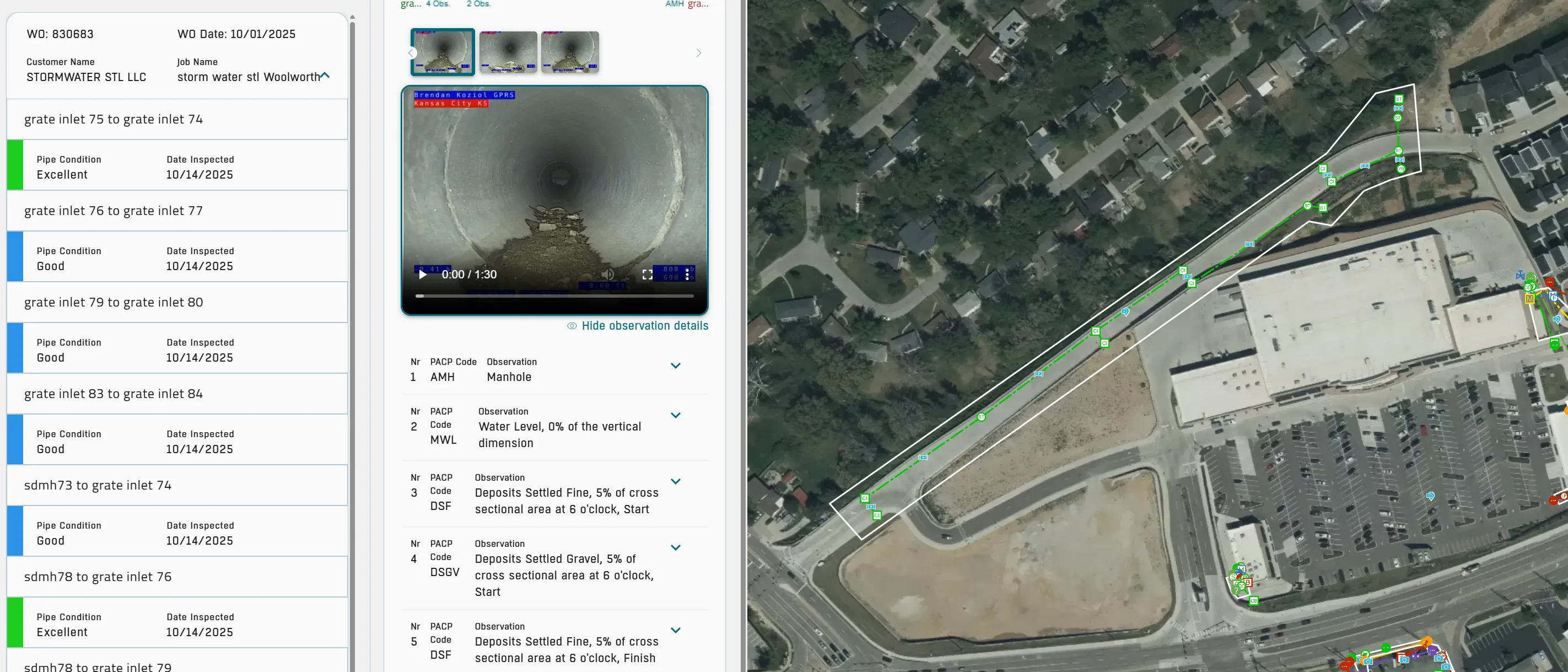
GPRS video pipe inspection services deploy robotic crawler CCTV cameras, lateral launch cameras, and push cameras to inspect and document water, sewer lines, and lateral pipelines to locate clogs, investigate cross bores, find structural faults and damage, and conduct lateral sewer line inspections. GPRS Project Managers deliver NASSCO-certified WinCan reports with the exact location, video, and photo of each defect, ranked by severity so you can plan for maintenance and repairs.
Leak Detection Services
GPRS specializes in all types of leak detection services, including municipal, industrial, and residential. Our Project Managers are leak detection specialists who utilize multiple technologies to locate your leak and have the expertise to map and provide many other insights into your water distribution and/or fire suppression systems. GPRS does this by utilizing a variety of equipment paired with our industry-leading SIM (Subsurface Investigation Methodology) processes. The equipment and methods used include acoustic leak detectors, leak noise correlators, video pipe inspection (CCTV) cameras & sondes, ground penetrating radar, and electromagnetic locating, among others.


CUSTOM SERVICE PLANS

Scheduling

Pricing

Approach

mapping & Modeling
GPRS delivers the most up-to-date, accurate and comprehensive site data possible in the format required for your project. We provide complimentary KMZ and PDF maps with every utility locate we perform. Our Mapping & Modeling Team can create a wide variety of customizable maps and models, from a simple GPS-enabled map of your utility locate, to highly-detailed 2D CAD drawings and 3D BIM models, depending on your needs.
AS BUILT DRAWINGS
2D MAPS & 3D MODELS
SITEMAP® MOBILE APP

One Call Program

Public Property
Private Property

Embedment
GPRS 3D Laser Scanning Services for the Agricultural Industry
GPRS utilizes Leica Geosystems 3D laser scanners to provide a safe and accurate means of collecting site and overhead data from the ground, providing vital detail for design planning and analysis. An experienced technician or small team can scan facilities and sites with very little interruption to site staff and production.
Utilizing a 3D laser scanner, GPRS Project Managers can safely and accurately gather massive amounts of measurement data. 3D laser scanners emit millions of laser light pulses and by timing their return, can precisely calculate their spatial locations. They work by digitally capturing the dimensions and spatial relationships of objects using the reflection of the laser light. A 360-degree scan is taken of a location with the option of capturing panoramic photos. Laser scanners are high-speed, they quickly capture large-scale sites and facilities.
When the existing conditions of sites are scanned, millions of data points from the surfaces of the objects are captured and the result is an accurate point cloud of the scanned areas.

What Can a Point Cloud Be Used For?
Aging, deformation, and movement are inevitable in the agricultural industry. 3D laser scanning is the most cost-effective tool to monitor large structures. Engineers use the point cloud data as a tool to create as-built drawings instead of taking hand measurements. Point clouds provide a single and accurate set of measurements that improve design as well as communication among facility managers, designers and contractors. They offer value by providing a single set of information that can easily be shared with the entire team.
A point cloud can be used to:
- Perform site arrangement
- Create a 3D model of overhead conveying systems
- Monitor defects in a structure and create a plan to stabilize the structure
- Check interferences with existing structures before construction
- Develop preventive maintenance plans
- Conduct floor flatness analysis/contour mapping
- Conduct volume calculations of storage bins
- Analyze a space to make sure that a piece of equipment will fit into that space
- Create digital walkthroughs of facilities
- Create a rapid prototype and visualization of changes in space with little modeling effort
- Create analysis reports
- Direct overlay into many 3D modeling software platforms
- Expedite design planning for site upgrades
Existing site data can be complimented by geo-referencing laser scan data with the help of local survey professionals. Geo-referenced point clouds provide millions of points detailing features and systems directly related to existing site coordinate systems. This option may be utilized by design professionals to expand existing site-specific data with the rich 3D accuracy of laser scan data. The redundant nature of a point cloud offers troubleshooting and alternate solution modeling beyond that of traditional hand sketches and field measurements.
3D laser scan data can be utilized in both 2D and 3D design software. Our team of in-house engineers can create a 3D BIM model or 2D CAD drawing of any scan data.
GPRS can provide the following deliverables:
- Intensity Map Point Cloud
- Colorized Point Cloud (requires adequate site lighting)
- TruView Files
- Volume Calculations
- Floor Flatness / Floor Levelness Analysis
- Clearance Calculations
- 2D Drawings (in .pdf format)
- 2D CAD Drawings (in .dwg format)
- 3D Model (non-intelligent solids only model)
- 3D BIM Model (intelligent model)
Proud Member of GEAPS
GPRS is a proud member of GEAPS, the Grain Elevator Processing Society. GEAPS advances grain industry knowledge and information sharing through a network of agricultural professionals.
3D Laser Scanning Pricing
The cost of 3D laser scanning can vary widely depending on your project scope. GPRS customizes every quote specific to your project’s needs. GPRS Project Managers use 3D laser scanners to capture every detail of your site, delivering building dimensions, locations, and layout with millimeter accuracy. This can include the aboveground structural, architectural, and MEP features, plus underground utility and concrete markings. Our Mapping & Modeling Team can deliver point clouds, 2D CAD drawings, 3D BIM models, 3D Mesh models, TruViews, and Virtual Tours at any level of detail.
GPRS Intelligently Visualizes The Built World® for agricultural processing and storage facilities to keep your projects on time, on budget, and safe.
Case Studies


Related Articles


.avif)

