Architectural

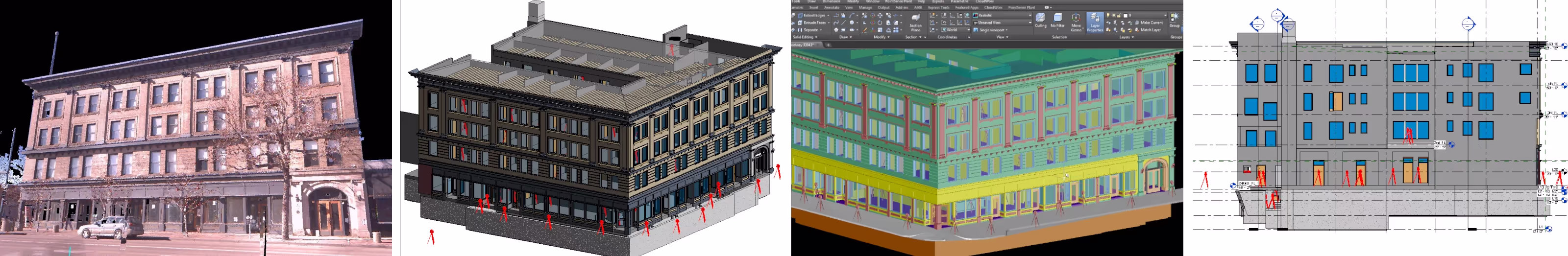
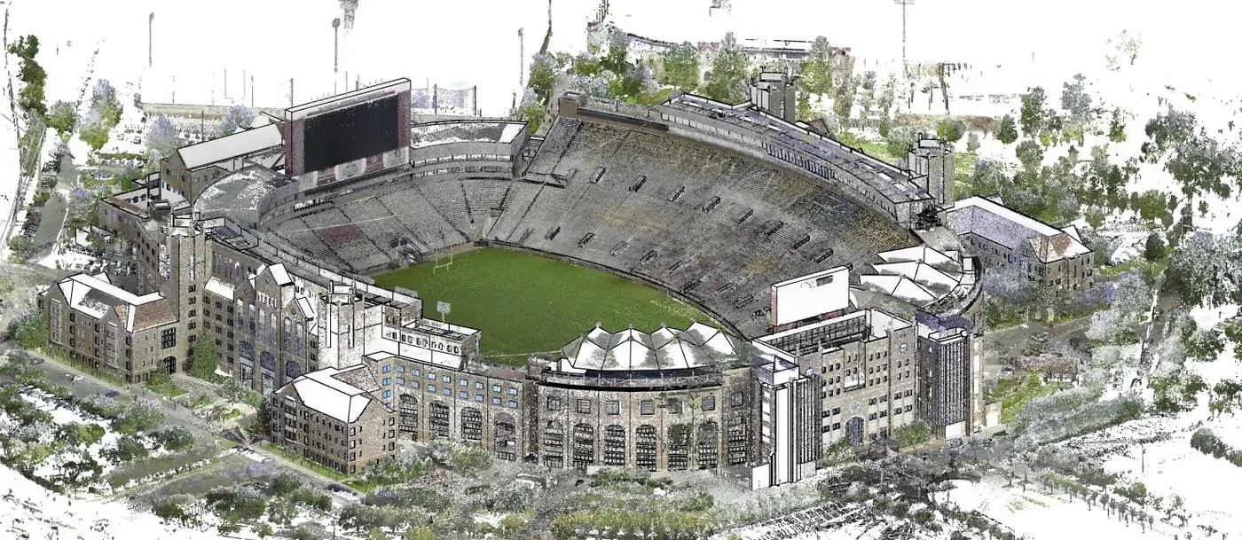
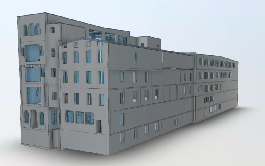
With architectural projects, an immense level of detail is needed to make sure no inaccuracies or unseen issues arise. GPRS captures full documentation of existing architectural conditions, aiding the process of architectural design from site survey, to monitoring construction progress, creating design models, and verifying as-built accuracy. GPRS provides utility locating, concrete scanning, 3D laser scanning, video pipe inspection, and leak detection services for the Architectural industry. GPRS quickly and accurately provides comprehensive as-built documentation of a building or site, from walls and windows to HVAC, mechanical, electrical, plumbing, subsurface utilities, concrete reinforcements, and more.

GPRS is highly experienced in architectural scanning, modeling, and data management. The precise data collected eliminates site revisits that eat up time and resources and lets your team focus on design rather than modeling existing conditions.

GPRS Architectural As-Built Services
GPRS captures full documentation of existing architectural conditions, aiding the process of architectural design from site survey, to monitoring construction progress, creating design models, and verifying as-built accuracy.

GPRS Delivers Complete Infrastructure Visualization

GPRS is the only company in the U.S. that can capture your entire site or facility, above and below-ground, to provide you with accurate as-builts, private and public utility maps, 2D CAD drawings, 3D BIM models, virtual tours, WinCan reports, and more documenting architectural, structural, MEP, and subsurface utility existing conditions, and instantly deliver data via SiteMap®, GPRS’ cloud-based digital storage software and app.

Utility Locating Services

GPRS utility locating services utilize ground penetrating radar (GPR) and electromagnetic (EM) locating technology to locate, mark, and map existing underground infrastructure such as power lines, gas lines, pipelines, water lines, sewer lines, potential voids, and additional buried facilities and utility lines. This information is critical for projects where construction or excavation activities are planned to mitigate accidental utility strikes, plus keep your team and facility safe. GPRS delivers complimentary CAD utility site maps in PDF, KMZ, and SHP file formats, and can export your utility data into a wide variety of drawings, maps, and models to advance communication and collaboration on your project. All clients receive instant access to complete and aggregated site records in Sitemap®, GPRS’ digital storage software and app, where data is geolocated, layered, and securely shareable.

Concrete Scanning Services

Concrete scanning is a non-destructive method to assess concrete using GPR to locate, identify, and mark utilities and objects such as rebar, post tension cables, beams, conduits, and piping embedded within concrete slabs and structures prior to anchoring, cutting, coring, and drilling. Concrete scanning ensures the safety of workers and prevents accidents by identifying potential hazards before any work occurs. Concrete markings can be 3D laser scanned to create a permanent record of the site, data can be delivered in 2D CAD drawings, 3D BIM models, and virtual site tours.

3D Laser Scanning Services

GPRS 3D laser scanning services document the exact architectural, structural, and MEP system layout and dimensions of existing buildings and sites. GPRS Project Managers use industry-leading Leica survey-grade laser scanners to capture 2-4 millimeter accurate existing site conditions in the form of a point cloud. Our in-house Mapping & Modeling Team can transform those point clouds into customized 2D CAD drawings, 3D BIM models, 3D mesh models, TruViews, and 3D virtual tours at any level of detail for visualization, analysis, design, construction, renovation, prefabrication, and facility modifications.

Video Pipe Inspection Services

GPRS video pipe inspection services deploy robotic crawler CCTV cameras, lateral launch cameras, and push cameras to inspect and document water, sewer lines, and lateral pipelines to locate clogs, investigate cross bores, find structural faults and damage, and conduct lateral sewer line inspections. GPRS Project Managers deliver NASSCO-certified WinCan reports with the exact location, video, and photo of each defect, ranked by severity so you can plan for maintenance and repairs.

Leak Detection Services

GPRS specializes in all types of leak detection services, including municipal, industrial, and residential. Our Project Managers are leak detection specialists who utilize multiple technologies to locate your leak and have the expertise to map and provide many other insights into your water distribution and/or fire suppression systems. GPRS does this by utilizing a variety of equipment paired with our industry-leading SIM (Subsurface Investigation Methodology) processes. The equipment and methods used include acoustic leak detectors, leak noise correlators, video pipe inspection (CCTV) cameras & sondes, ground penetrating radar, and electromagnetic locating, among others.

Let's Get To Work
Schedule A Project

No items found.
Settings Slider icon

CUSTOM SERVICE PLANS

Rather than send a rigid rate sheet to prospective clients, GPRS can create a customized service plan. We take into account our industry experience, national footprint, and operational/scheduling capacity to craft a customized plan just for you.
Schedule Icon

Scheduling

With one single point of contact for your company, GPRS can schedule underground utility locating, 3D laser scanning, concrete scanning, video pipe inspection, and void detection services for your site with a simple phone call. There is no need to call multiple service providers across a region or nationally. GPRS has Project Managers in every major market in the US and our single point of contact will simplify your scheduling process.
Pricing

Pricing

GPRS understands that clear, understandable, and consistent pricing is a big deal. Our nationwide footprint allows us to streamline our costs on a nationwide basis. We are sure to craft a cost structure that makes sense for the scope of work. Rather than send a blanket rate sheet, we consultatively compose pricing plans for each project.
approach icon

Approach

Every campus, site, and facility pose different challenges. Since our inception, GPRS has completed hundreds of thousands of projects and relies on that experience when crafting a site-specific plan for safety, scanning, and reporting. With the SIM Specification as our guide, we will craft an individualized approach to each and every project. We Intelligently Visualize The Built World™ from facility mapping to utility locating prior to excavation, and will perform the right service for your scope of work.
Mapping and modeling  - GPRS -  Ground Penetrating Radar

mapping & Modeling

GPRS improves project planning and communication by providing clear and understandable maps and models to help you Visualize The Built World™ and share your vision with subcontractors, designers, engineers, and others, easily.

GPRS delivers the most up-to-date, accurate and comprehensive site data possible in the format required for your project. We provide complimentary KMZ and PDF maps with every utility locate we perform. Our Mapping & Modeling Team can create a wide variety of customizable maps and models, from a simple GPS-enabled map of your utility locate, to highly-detailed 2D CAD drawings and 3D BIM models, depending on your needs.

AS BUILT DRAWINGS

Existing drawings don't always show the current conditions of a site. Drawings that are produced in the design phase of a project don't always reflect the exact location of the underground utilities and current as built site conditions. Renovations, repairs, and additions can all render as built drawings out of date. The GPRS Mapping & Modeling Team can deliver up-to-date as built drawings that reflect the actual vertical and horizontal position of underground facilities & features, and structural, architectural, and MEP site details.

2D MAPS & 3D MODELS

Utility locates, concrete scanning, and 3D laser scan data can be processed into up-to-date 2D maps and 3D models to ensure that your team has all the information you need to get the job done right. These maps and models provide an accurate record of utility locations and as-builts for project planning.
The GPRS Mapping & Modeling Team will deliver point cloud data, 2D CAD drawings, 3D BIM models, 3D meshes, TruViews, and virtual tours produced with the highest quality standards. We provide high-precision custom analysis and calculations such as dimensional callouts, tank calibration analysis, floor flatness and levelness analysis, deviation analysis, deformation analysis, volume calculations, wall plumb analysis, and more.
Maps, models, and analyses are produced and hosted for your use at any level of detail in a variety of formats such as Revit, AutoCAD, ReCap, Navisworks, Civil 3D, BIM360, A360, Bentley, Leica Cyclone, Cintoo, NavVis Ivion, and more. The GPRS Mapping & Modeling Team has optimized workflows for importing data, registration, creating maps and models, quality checks, and transferring data to clients. We deliver the data you need in the format you need to access up-to-date and accurate facility and infrastructure information.

SITEMAP® MOBILE APP

When we conduct an underground utility locate, GPRS stores all subsurface infrastructure data in SiteMap®, a secure digital platform that houses all your utility locate PDF and KMZ files. You can access your data from any laptop or mobile device and securely share it with your team. Within your files, you will find interactive subsurface maps, annotations, and more, where you can toggle layers and lines on or off to streamline information and communicate only the data you need. You can even measure site features and segment maps geographically to drill down to specific project points for prefabrication or excavation needs.
GPRS Project Managers can complete multiple mobilizations to a jobsite – before, during and after construction – to record subsurface and as built data in real-time. The data captured can be tied together into living maps and models and saved into a database for reference.
How can GPRS can help you streamline your next project to Intelligently Visualize Your Built World™?
One Call Program

One Call Program

GPRS exceed industry performance when it comes to the accuracy of our utility locating. Our team of Project Managers can continue the support of your project by crafting a one-call program from when your project transitions to the O&M phase.
Public Property

Public Property

Damage prevention is critical when excavating in a public right-of-way. Using the 811, call before you dig system, is an essential step to take when trying to avoid underground utility strikes. It's the law! GPRS is able to contract and perform one-call type utility locating for your underground assets.
Public Property

Private Property

A utility locate on private property is not complete until a private utility locator like GPRS has been called to comprehensively locate the entire campus. GPRS can create a one-call type program for your facility or campus in the case that you have utilities that lie within public property.
Embedment

Embedment

Our highly trained Project Managers have extensive experience locating conduits, rebar, cables, pipes, ducts, sleeves, and other hazards embedded in concrete slabs and other structures with ground penetrating radar technology. Cutting, coring, or drilling into these objects can cause damage to utilities and jeopardize the health and safety of workers on site.

What are the Benefits of GPRS Architectural As-Built Services?

  • Complete documentation of as-built conditions
  • Precise, high speed data collection
  • Dimensionally accurate, measurable, and shareable data sets
  • Fast turnaround of project data
  • Decreased disruption of project environment
  • Reduced need for site revisits
  • Safe solution for inaccessible locations
  • Reduction in change orders, delays, and cost overruns

What Customizable Maps & Models Can GPRS Deliver?

  • Point Cloud Data
  • 2D CAD Drawings
  • 3D BIM Models | Building Information Models
  • 3D Mesh Models
  • 3D Photogrammetry
  • TruView
  • Virtual Tours via WalkThru 3D
  • 2D Floor Plans via FLRPLN
  • 3D CAD Floor Plans via FLRPLN
  • Template Modeling
  • Reconciliation of Clients 2D Drawings
  • Reconciliation of Clients 3D Design Model
  • Comparative Analysis
  • Deformation Analysis
  • Floor Flatness Analysis | Floor Contour Mapping
  • Volume Calculations
  • Structural Steel Shape Probability Analysis
  • Wall Plumb Analysis
  • New Construction Accuracy Analysis
  • New Construction Comparative Analysis
  • 2D CAD of GPR Markings
  • Reflected Ceiling Plans
  • Emergency Floor Plans
  • 2D CAD Plan Views, Elevations, Sections, Details, Isometric Drawings

GPRS Pricing

The cost of GPRS services can vary widely depending on your project scope. GPRS customizes every quote specific to your project’s needs. GPRS Project Managers use the latest technology to capture every detail of your site, delivering building dimensions, locations, and layout with millimeter accuracy. This can include the aboveground structural, architectural, and MEP features, plus underground utility and concrete markings. Our Mapping & Modeling Team can deliver point clouds, 2D CAD drawings, 3D BIM models, 3D Mesh models, TruViews, and Virtual Tours at any level of detail.

What can we help you visualize?

FREQUENTLY ASKED QUESTIONS

right arrow  - GPRS -  Ground Penetrating Radar

Will you be able to work with my schedule to avoid disrupting business operations?

Yes! GPRS tailors our services to meet your needs, and that includes working nights and weekends to help limit disruptions to normal business operations. The equipment that GPRS uses is battery operated, emits less radiation than a cell phone, and less noise than a household vacuum cleaner, allowing us to work discreetly.

right arrow  - GPRS -  Ground Penetrating Radar

Can you provide services quickly?

Yes! Our nationwide presence means that a GPRS ProjectManager will be on your jobsite as quickly as 24 hours after initial contact.

right arrow  - GPRS -  Ground Penetrating Radar

Do you have enough manpower to cover multiple stores/sites at one time?

Yes! With over 500 Project Managers strategically stationed across every major market in the U.S., we can respond rapidly to as many sites as needed.

right arrow  - GPRS -  Ground Penetrating Radar

What do I get when you conduct a service for me?

GPRS provides a Job Summary report with basic project information for very project we complete. We also provide complimentary KMZ and PDF maps with every utility locate we perform. And, when we perform a utility locate for you, you receive a complimentary Personal subscription to SiteMap®, our industry-leading, cloud-based infrastructure management platform where you can access, view, and securely share your digitized, layered utility maps 24/7. Beyond that, our Mapping & Modeling Team can create anything from a simple, GPS-enabled locating map of your utility locate, to highly detailed, 2D CAD drawings and 3D BIM models, depending on your needs.

right arrow  - GPRS -  Ground Penetrating Radar

Can you complete your work without my team on site?

Yes, GPRS Project Managers have the capability to complete work with, or without your team present on site, as long as access is granted to the work area. Details of our findings will be communicated to your team immediately upon completion of each project.

GPRS Employees at work | GPRS Image